| Wrong Peak | |
|---|---|
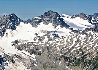 East aspect, centered (Erratum Peak to left) | |
| Highest point | |
| Elevation | 2,869 m (9,413 ft)12 |
| Prominence | 207 m (679 ft)3 |
| Parent peak | Scylla Mountain (2,920 m)3 |
| Isolation | 2.9 km (1.8 mi)3 |
| Listing | Mountains of British Columbia |
| Coordinates | 50°53′35″N 117°22′04″W / 50.89306°N 117.36778°W / 50.89306; -117.367784 |
| Geography | |
Wrong Peak Location in British Columbia Show map of British ColumbiaWrong Peak Location in Canada Show map of Canada | |
 | |
| Interactive map of Wrong Peak | |
Country | Canada |
Province | British Columbia |
District | Kootenay Land District5 |
| Parent range | Selkirk Mountains Battle Range |
| Topo map | NTS 82K14 Westfall River4 |
| Climbing | |
| First ascent | July 1959 |
Wrong Peak is a 2,869-metre (9,413-foot) summit in British Columbia, Canada.
Description
Wrong Peak is located in the Battle Range of the Selkirk Mountains. The remote peak is set approximately 8 km (5.0 mi) southwest of Nautilus Mountain and the nearest higher neighbor is Scylla Mountain, 2.9 km (1.8 mi) to the west-northwest.3 Precipitation runoff from the mountain drains north to Houston Creek and south to Westfall River, which are both tributaries of the Duncan River. Wrong Peak is more notable for its steep rise above local terrain than for its absolute elevation. Topographic relief is significant as the summit rises 1,400 meters (4,593 ft) above the Westfall River in 5 km (3.1 mi).
History
The first ascent of the summit was made in 1959 by Samuel Silverstein and party.6
The peak was named in 1962 in association with the Wrong Glacier. The glacier is so named because a food cache was mistakenly air dropped here instead of the intended destination, Houston Glacier, which is five kilometers further northwest.1 The mountain's toponym was officially adopted on September 14, 1967, by the Geographical Names Board of Canada.4
Climate
Based on the Köppen climate classification, Wrong Peak is located in a subarctic climate zone with cold, snowy winters, and mild summers.7 Winter temperatures can drop below −20 °C with wind chill factors below −30 °C. This climate supports the Wrong Glacier on the north slope of the peak and a small unnamed glacier on the east slope.
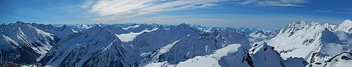
Gallery
References
References
- Glen W. Boles, William Lowell Putnam, Roger W. Laurilla (2006), "Canadian Mountain Place Names", Rocky Mountain Books, ISBN 9781894765794, p. 273.
- BC Basemap topographic map
- "Wrong Peak, Peakvisor.com". Retrieved 2023-02-19.
- "Wrong Peak". Geographical Names Data Base. Natural Resources Canada. Retrieved 2023-02-19.
- "Wrong Peak". BC Geographical Names. Government of British Columbia – B.C. Geographical Names Office (BCGNO). Retrieved 2023-02-19.
- Samuel Silverstein (1960), Battle Range, Southern Selkirks, Americanalpineclub.org
- Peel, M. C.; Finlayson, B. L.; McMahon, T. A. (2007). "Updated world map of the Köppen-Geiger climate classification" (PDF). Hydrology and Earth System Sciences. 11 (5): 1633–1644. Bibcode:2007HESS...11.1633P. doi:10.5194/hess-11-1633-2007. Archived (PDF) from the original on 2019-12-02. Retrieved 2025-11-07.