| Winfarthing | |
|---|---|
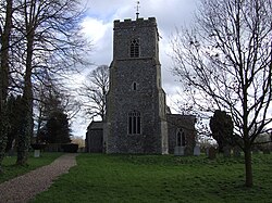 Church of Saint Mary the Virgin, Winfarthing | |
Winfarthing Location within Norfolk | |
| Area | 10.80 km2 (4.17 sq mi) |
| Population | 503 (2011) |
| • Density | 47/km2 (120/sq mi) |
| OS grid reference | TM108857 |
| Civil parish |
|
| District | |
| Shire county | |
| Region | |
| Country | England |
| Sovereign state | United Kingdom |
| Post town | DISS |
| Postcode district | IP22 |
| Dialling code | 01379 |
| Police | Norfolk |
| Fire | Norfolk |
| Ambulance | East of England |
Winfarthing is a village and civil parish in the English county of Norfolk. It is located 4 miles (6 km) north of the town of Diss, 12 miles (19 km) east of the town of Thetford, and 19 miles (31 km) south of the city of Norwich.1 The gold and garnet Anglo Saxon Winfarthing pendant was found nearby in 2014.
The civil parish has an area of 4.2 sq mi (10.8 km2) and in the 2001 census had a population of 403 in 162 households, the population increasing to 503 at the 2011 Census.2 For the purposes of local government, the parish falls within the district of South Norfolk.3
The village is the site of the grade I listed St Mary's church.4
History
The place-name 'Winfarthing' is first attested in the Domesday Book of 1086, where it appears as Wineferthinc. The name means "Wina's quarter part". The name of the former English coin the farthing has a similar origin, meaning "the fourth part (of a penny)".5
The parish of Winfarthing was a demesne of the King until around 1189 in the reign of Henry II, when it was sold off to a private landowner. In 1600, there were 189 communicants, and by 1739, there were 50 dwelling-houses, and about 260 inhabitants in total, at which point the parish was valued for tax purposes at £924 (£172000 today).6
The Anglo-Saxon Winfarthing pendant was found in a nearby field in 2014, in a woman's grave. It is made of gold with garnets, and is held in Norwich Castle Museum.7
References
References
- Ordnance Survey (1999). OS Explorer Map 230 - Diss & Harleston. ISBN 0-319-21862-7.
- "Civil Parish population 2011". Retrieved 5 September 2015.
- Office for National Statistics & Norfolk County Council (2001). Census population and household counts for unparished urban areas and all parishes Archived 2017-02-11 at the Wayback Machine. Retrieved 2 December 2005.
- Historic England. "Church of St Mary (1180035)". National Heritage List for England.
- Eilert Ekwall, The Concise Oxford Dictionary of English Place-names, p.523.
- Blomefield, Francis (c. 1736). . Vol. 1. London (published 1805–1810).
- Parkin, Simon. "Norfolk treasure named Britain's favourite new museum artefact". Eastern Daily Press. Retrieved 2 July 2023.
- Winfarthing parish data, South Norfolk Council. Retrieved 20 June 2009.
External links
External links
- Diss Express - village's local newspaper website
- Map sources for Winfarthing.
- Information from Genuki Norfolk on Winfarthing.