| Waputik Range | |
|---|---|
 Waputik Range seen from the Icefields Parkway | |
| Highest point | |
| Peak | Mount Balfour |
| Elevation | 3,272 m (10,735 ft)1 |
| Coordinates | 51°33′55″N 116°27′58″W / 51.56528°N 116.46611°W / 51.56528; -116.466112 |
| Dimensions | |
| Length | 19 km (12 mi)3 |
| Width | 19 km (12 mi)3 |
| Area | 235 km2 (91 mi2)3 |
| Geography | |
Waputik Range Waputik Range | |
Country | Canada |
Provinces | Alberta and British Columbia |
Range coordinates | 51°31′59″N 116°22′02″W / 51.53306°N 116.36722°W / 51.53306; -116.367224 |
| Parent range | Waputik Mountains |
| Topo map | NTS 82N9 Hector Lake |
The Waputik Range lies west of the upper Bow Valley, east of Bath Creek, and south of Balfour Creek in the Canadian Rockies. "Waputik" means "white goat" in Stoney.5 The range was named in 1884 by George Mercer Dawson of the Geological Survey of Canada.6 The President Range lies within the Waputik Range.
The Waputik Range should not be confused with the much larger Waputik Mountains which encompasses this range and other peaks along the Continental Divide in Yoho National Park.
Mountains and Peaks
Gallery
-
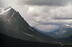 Waputik Range
References
References
- "Mount Balfour". cdnrockiesdatabases.ca. Retrieved 2022-09-04.
- "Mount Balfour". BC Geographical Names. Government of British Columbia – B.C. Geographical Names Office (BCGNO). Retrieved 2022-09-04.
- "Waputik Range". Peakbagger.com. Retrieved 2013-06-08.
- "Waputik Range". Geographical Names Data Base. Natural Resources Canada. Retrieved 2013-06-08.
- "Waputik Mountains". BC Geographical Names. Government of British Columbia – B.C. Geographical Names Office (BCGNO). Retrieved 2022-09-04.
- Boles, Glen W.; Laurilla, Roger W.; Putnam, William L. (2006). Canadian Mountain Place Names: the Rockies and Columbia Mountains. Vancouver: Rocky Mountain Books. p. 264. ISBN 978-1-894765-79-4. OCLC 244770225.