Walik | |
|---|---|
Hamlet | |
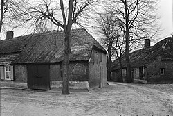 Farms in Walik (1964) | |
Walik Location in the province of North Brabant in the Netherlands Show map of North BrabantWalik Walik (Netherlands) Show map of Netherlands | |
| Coordinates: 51°21′11″N 5°21′48″E / 51.3531°N 5.3632°E / 51.3531; 5.3632 | |
| Country | Netherlands |
| Province | North Brabant |
| Municipality | Bergeijk |
| Area | |
• Total | 0.49 km2 (0.19 sq mi) |
| Elevation | 28 m (92 ft) |
| Population (2021)1 | |
• Total | 405 |
| • Density | 830/km2 (2,100/sq mi) |
| Time zone | UTC+1 (CET) |
| • Summer (DST) | UTC+2 (CEST) |
| Postal code | 55611 |
| Dialing code | 040 |
Walik (Dutch pronunciation: [ˈʋaːlɪk]) is a hamlet in the North-Brabant municipality of Bergeijk and is located to the west of the village of Riethoven.3
Walik is an agricultural community with some farms located near a brink (village square).3
The hamlet was first mentioned between 1838 and 1857 as Waalwijk, and means "settlement around a pool'.45 There are three farms around the brink which are characteristic examples of Campian long gable farms and have been declared a monument.6
References
References
- "Kerncijfers wijken en buurten 2021". Central Bureau of Statistics. Retrieved 15 April 2022.
- "Postcodetool for 5561AA". Actueel Hoogtebestand Nederland (in Dutch). Het Waterschapshuis. Archived from the original on 25 December 2018. Retrieved 14 April 2022.
- Chris Kolman & Ronald Stenvert (1997). Riethoven (in Dutch). Zwolle: Waanders. ISBN 90 400 9945 6. Retrieved 15 April 2022.
- "Walik - (geografische naam)". Etymologiebank (in Dutch). Retrieved 15 April 2022.
- "Waalwijk - (geografische naam)". Etymologiebank (in Dutch). Retrieved 15 April 2022.
- "Walik". Plaatsengids (in Dutch). Retrieved 15 April 2022.