Villard-Reymond | |
|---|---|
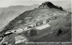 Villard-Reymond in 1937 | |
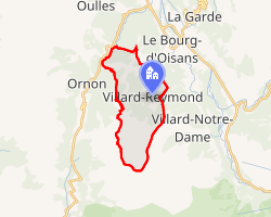 Location of Villard-Reymond | |
Villard-Reymond Villard-Reymond | |
| Coordinates: 45°02′00″N 6°01′05″E / 45.0333°N 6.018°E / 45.0333; 6.018 | |
| Country | France |
| Region | Auvergne-Rhône-Alpes |
| Department | Isère |
| Arrondissement | Grenoble |
| Canton | Oisans-Romanche |
| Government | |
| • Mayor (2020–2026) | Chantal Theysset1 |
Area 1 | 11 km2 (4.2 sq mi) |
| Population (2023)2 | 46 |
| • Density | 4.2/km2 (11/sq mi) |
| Time zone | UTC+01:00 (CET) |
| • Summer (DST) | UTC+02:00 (CEST) |
| INSEE/Postal code | 38551 /38520 |
| Elevation | 840–2,732 m (2,756–8,963 ft) (avg. 1,600 m or 5,200 ft) |
| 1 French Land Register data, which excludes lakes, ponds, glaciers > 1 km2 (0.386 sq mi or 247 acres) and river estuaries. | |
Villard-Reymond (French pronunciation: [vilaʁ ʁemɔ̃]) is a commune in the Isère department in southeastern France.3
Population
| Year | Pop. | ±% p.a. |
|---|---|---|
| 1968 | 14 | — |
| 1975 | 7 | −9.43% |
| 1982 | 25 | +19.94% |
| 1990 | 21 | −2.16% |
| 1999 | 31 | +4.42% |
| 2007 | 47 | +5.34% |
| 2012 | 36 | −5.19% |
| 2017 | 43 | +3.62% |
| 2023 | 46 | +1.13% |
| Source: INSEE4 | ||
References
References
- "Répertoire national des élus: les maires". data.gouv.fr, Plateforme ouverte des données publiques françaises (in French). 2 December 2020.
- "Populations de référence 2023" (in French). National Institute of Statistics and Economic Studies. 18 December 2025.
- INSEE commune file
- Population municipale entre 1968 et 2023, INSEE