Vigoux | |
|---|---|
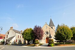 The church in Vigoux | |
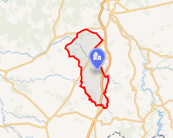 Location of Vigoux | |
Vigoux Vigoux | |
| Coordinates: 46°30′40″N 1°29′18″E / 46.5111°N 1.4883°E / 46.5111; 1.4883 | |
| Country | France |
| Region | Centre-Val de Loire |
| Department | Indre |
| Arrondissement | Le Blanc |
| Canton | Saint-Gaultier |
| Intercommunality | Brenne Val de Creuse |
| Government | |
| • Mayor (2021–2026) | Brigitte Beigneux-Pipereau1 |
Area 1 | 37.51 km2 (14.48 sq mi) |
| Population (2023)2 | 472 |
| • Density | 12.6/km2 (32.6/sq mi) |
| Time zone | UTC+01:00 (CET) |
| • Summer (DST) | UTC+02:00 (CEST) |
| INSEE/Postal code | 36239 /36170 |
| Elevation | 168–269 m (551–883 ft) (avg. 211 m or 692 ft) |
| 1 French Land Register data, which excludes lakes, ponds, glaciers > 1 km2 (0.386 sq mi or 247 acres) and river estuaries. | |
Vigoux (French pronunciation: [viɡu]) is a commune in the Indre department in central France.3
Geography
The river Abloux forms all of the commune's southwestern border.
Population
| Year | Pop. | ±% p.a. |
|---|---|---|
| 1968 | 534 | — |
| 1975 | 439 | −2.76% |
| 1982 | 376 | −2.19% |
| 1990 | 399 | +0.74% |
| 1999 | 445 | +1.22% |
| 2007 | 464 | +0.52% |
| 2012 | 460 | −0.17% |
| 2017 | 461 | +0.04% |
| 2023 | 472 | +0.39% |
| Source: INSEE4 | ||
References
References
- "Répertoire national des élus: les maires". data.gouv.fr, Plateforme ouverte des données publiques françaises (in French). 9 August 2021.
- "Populations de référence 2023" (in French). National Institute of Statistics and Economic Studies. 18 December 2025.
- INSEE commune file
- Population municipale entre 1968 et 2023, INSEE