Valdeblore | |
|---|---|
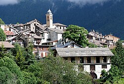 A view of La Bolline, in Valdebore, with the bell tower of the chapel of the Pénitents Blancs | |
 Coat of arms | |
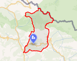 Location of Valdeblore | |
Valdeblore Valdeblore | |
| Coordinates: 44°04′19″N 7°10′19″E / 44.0719°N 7.1719°E / 44.0719; 7.1719 | |
| Country | France |
| Region | Provence-Alpes-Côte d'Azur |
| Department | Alpes-Maritimes |
| Arrondissement | Nice |
| Canton | Tourrette-Levens |
| Intercommunality | Métropole Nice Côte d'Azur |
| Government | |
| • Mayor (2020–2026) | Carole Cervel1 |
Area 1 | 94.16 km2 (36.36 sq mi) |
| Population (2023)2 | 835 |
| • Density | 8.87/km2 (23.0/sq mi) |
| Time zone | UTC+01:00 (CET) |
| • Summer (DST) | UTC+02:00 (CEST) |
| INSEE/Postal code | 06153 /06420 |
| Elevation | 399–2,880 m (1,309–9,449 ft) (avg. 1,050 m or 3,440 ft) |
| 1 French Land Register data, which excludes lakes, ponds, glaciers > 1 km2 (0.386 sq mi or 247 acres) and river estuaries. | |
Valdeblore (French pronunciation: [valdəblɔʁ]; Vivaro-Alpine: Val de Blora; Italian: Valdiblora) is a commune in the Alpes-Maritimes department in the Provence-Alpes-Côte d'Azur region in southeastern France.
Population
| Year | Pop. | ±% p.a. |
|---|---|---|
| 1968 | 556 | — |
| 1975 | 466 | −2.49% |
| 1982 | 584 | +3.28% |
| 1990 | 664 | +1.62% |
| 1999 | 686 | +0.36% |
| 2007 | 806 | +2.04% |
| 2012 | 908 | +2.41% |
| 2017 | 853 | −1.24% |
| 2023 | 835 | −0.35% |
| Source: INSEE3 | ||
References
References
- "Répertoire national des élus: les maires". data.gouv.fr, Plateforme ouverte des données publiques françaises (in French). 2 December 2020.
- "Populations de référence 2023" (in French). National Institute of Statistics and Economic Studies. 18 December 2025.
- Population municipale entre 1968 et 2023, INSEE