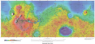
 Map of the lower and mid-latitudes of Mars, with Utopia visible in dark blue in the top right | |
| Location | Mars |
|---|---|
| Coordinates | 46°42′N 117°30′E / 46.7°N 117.5°E / 46.7; 117.5 |
| Diameter | c. 3,300 km (2,100 mi)1 |
| Impactor diameter | c. 550 km |
| Age | c. 4.2 billion years |
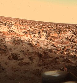
Utopia Planitia (Greek and Latin: "Utopia Land Plain") is a large plain2 within Utopia, the largest recognized impact basin on Marsa and in the Solar System with an estimated diameter of 3,300 km (2,100 mi).1 It is the Martian region where the Viking 2 lander touched down and began exploring on September 3, 1976, and the Zhurong rover touched down on May 14, 2021, as a part of the Tianwen-1 mission.45 It is located at the antipode of Argyre Planitia, centered at 46°42′N 117°30′E / 46.7°N 117.5°E / 46.7; 117.5.2 It is also in the Casius quadrangle, Amenthes quadrangle, and the Cebrenia quadrangle of Mars. The region is in the broader North Polar/Borealis Basin that covers most of the Northern Hemisphere of Mars.
The Utopia basin is estimated to have formed around 4.3-4.1 billion years ago.67 The impactor was likely around 400–700 kilometres (250–430 mi) in diameter.8910 The basin was subsequently mostly filled in, resulting in a mascon (a strong positive gravity anomaly) detectable by orbiting satellites.1112
Many rocks at Utopia Planitia appear perched, as if wind removed much of the soil at their bases.1314 A hard surface crust is formed by solutions of minerals moving up through soil and evaporating at the surface.15 Some areas of the surface exhibit scalloped topography, a surface that looks like it was carved out by an ice cream scoop. This surface is thought to have formed by the degradation of an ice-rich permafrost.16 Many features that look like pingos on the Earth are found in Utopia Planitia (~35–50° N; ~80–115° E).17
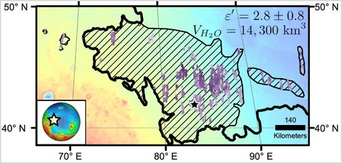
On November 22, 2016, NASA reported finding a large amount of underground ice in the Utopia Planitia region. The volume of water detected has been estimated to be equivalent to the volume of water in Lake Superior.181920
In 2026, research was published that showed a sort of "bathtub ring" in parts of Utopia. This was interpreted to be deposits of Manganese oxides that were depostied by an ocean. Manganese oxides can act as marker for past oceans, especially around ancient water-air boundaries. Manganese minerals react easily with oxygen. In oxygen-poor water, manganese remains in its dissolved, soluble form. But, when oxygen becomes available it is oxidized into insoluble solid oxides, which can become signatures of water activity. The team involved analyzed short-wave infrared (SWIR) data from China's Zhurong rover, ESA's OMEGA orbiter and NASA's CRISM orbiter to map the Manganese (hydr)oxides. They estimated that the ocean lasted around 0.8–1.5 million years.21 22
Scalloped topography
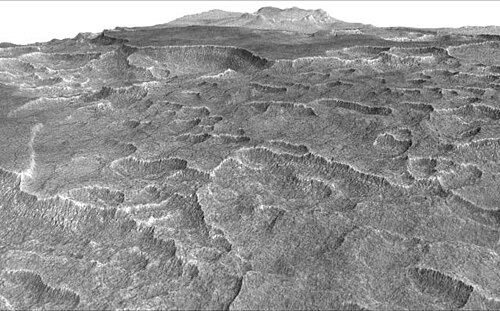
Scalloped topography is common in the mid-latitudes of Mars, between 45° and 60° north and south. It is particularly prominent in the region of Utopia Planitia2324 in the northern hemisphere and in the region of Peneus and Amphitrites Patera2526 in the southern hemisphere. Such topography consists of shallow, rimless depressions with scalloped edges, commonly referred to as scalloped depressions or simply scallops. Scalloped depressions can be isolated or clustered and sometimes seem to coalesce. A typical scalloped depression displays a gentle equator-facing slope and a steeper pole-facing scarp. This topographic asymmetry is probably due to differences in insolation. Scalloped depressions are believed to form from the removal of subsurface material, possibly interstitial ice, by sublimation. This process may still be happening at present.27
In popular culture
In the Star Trek media franchise, Utopia Planitia—both on Mars's surface and a space station in areosynchronous orbit above it—is the site of a major United Federation of Planets shipyard, the Utopia Planitia Fleet Yards. Ships such as the USS Enterprise-D, USS Defiant, USS Voyager, and USS Sao Paulo were built there.28
References
References
- McGill, G. E. (1989-03-10). "Buried topography of Utopia, Mars: Persistence of a giant impact depression". Journal of Geophysical Research. 94: 2753–2759. Bibcode:1989JGR....94.2753M. doi:10.1029/JB094iB03p02753.
- "Utopia Planitia". Gazetteer of Planetary Nomenclature. USGS Astrogeology Science Center. Retrieved 2015-03-10.
- "Utopia". Gazetteer of Planetary Nomenclature. USGS Astrogeology Science Center.
- "China succeeds on country's first Mars landing attempt with Tianwen-1". nasaspaceglight.com. 15 May 2021. Retrieved May 15, 2021.
- "China's first Mars rover Tianwen-1 launches this week. Here's what it will do". Space.com. 21 July 2020.
- Robbins, Stuart J. (2022-12-01). "Inconsistency between the Ancient Mars and Moon Impact Records of Megameter-scale Craters". The Planetary Science Journal. 3 (12): 274. doi:10.3847/PSJ/aca282. ISSN 2632-3338.
- Frey, Herbert (July 2008). "Ages of very large impact basins on Mars: Implications for the late heavy bombardment in the inner solar system". Geophysical Research Letters. 35 (13). doi:10.1029/2008GL033515. ISSN 0094-8276.
- Arkani-Hamed, Jafar (April 2005). "Giant impact basins trace the ancient equator of Mars". Journal of Geophysical Research: Planets. 110 (E4). doi:10.1029/2004JE002343. ISSN 0148-0227.
- Ruedas, Thomas; Breuer, Doris (May 2018). ""Isocrater" impacts: Conditions and mantle dynamical responses for different impactor types". Icarus. 306: 94–115. arXiv:1802.08578. doi:10.1016/j.icarus.2018.02.005.
- Branco, Hely C.; Miljkovic, Katarina; Plesa, Ana‐Catalina (April 2024). "New Numerically Derived Scaling Relationships for Impact Basins on Mars". Journal of Geophysical Research: Planets. 129 (4). doi:10.1029/2023JE008217. ISSN 2169-9097.
- Klokočník, Jaroslav; Kletetschka, Gunther; Kostelecký, Jan; Bezděk, Aleš (December 2023). "Gravity aspects for Mars". Icarus. 406 115729. doi:10.1016/j.icarus.2023.115729.
- Searls, Mindi L.; Banerdt, W. Bruce; Phillips, Roger J. (August 2006). "Utopia and Hellas basins, Mars: Twins separated at birth". Journal of Geophysical Research: Planets. 111 (E8). doi:10.1029/2005JE002666. ISSN 0148-0227.
- Mutch, T. et al. 1976. "The Surface of Mars: The View from the Viking 2 Lander". Science: 194. 1277–1283.
- Hartmann, W. 2003. A Traveler's Guide to Mars. Workman Publishing. New York.
- Arvidson, R. A. Binder, and K. Jones. 1976. "The Surface of Mars". Scientific American: 238. 76–89.
- Sejourne, A. et al. 2012. Evidence of an eolian ice-rich and stratified permafrost in Utopia Planitia, Mars. Icarus. 60:248–254.
- Soare, E., et al. 2019. Possible (closed system) pingo and ice-wedge/thermokarst complexes at the mid latitudes of Utopia Planitia, Mars. Icarus. doi:10.1016/j.icarus.2019.03.010
- Staff (November 22, 2016). "Scalloped Terrain Led to Finding of Buried Ice on Mars". NASA. Retrieved November 23, 2016.
- "Lake of frozen water the size of New Mexico found on Mars – NASA". The Register. November 22, 2016. Retrieved November 23, 2016.
- "Mars Ice Deposit Holds as Much Water as Lake Superior". NASA. November 22, 2016. Retrieved November 23, 2016.
- "MSN". Msn.com. Retrieved Jun 23, 2026.
- Hou, B., Sun, H.,Hu, Z. et al. Hou, B., Sun, H., Hu, Z. et al. Manganese (Hydr)oxides record the dynamic evolution of a million-year Hesperian Ocean in Utopia Planitia, Mars. Nat Commun(2026). https://doi.org/10.1038/s41467-026-72858-y (Hydr)oxides record the dynamic evolution of a million-year Hesperian Ocean in Utopia Planitia, Mars. Nat Commun (2026). https://doi.org/10.1038/s41467-026-72858-y
- Lefort, A.; Russell, P. S.; Thomas, N.; McEwen, A. S.; Dundas, C. M.; Kirk, R. L. (2009). "Observations of periglacial landforms in Utopia Planitia with the High Resolution Imaging Science Experiment (HiRISE)". Journal of Geophysical Research. 114 (E4): E04005. Bibcode:2009JGRE..114.4005L. doi:10.1029/2008JE003264.
- Morgenstern, A; Hauber, E; Reiss, D; van Gasselt, S; Grosse, G; Schirrmeister, L (2007). "Deposition and degradation of a volatile-rich layer in Utopia Planitia, and implications for climate history on Mars" (PDF). Journal of Geophysical Research: Planets. 112 (E6): E06010. Bibcode:2007JGRE..112.6010M. doi:10.1029/2006JE002869.
- Lefort, A.; Russell, P.S.; Thomas, N. (2010). "Scalloped terrains in the Peneus and Amphitrites Paterae region of Mars as observed by HiRISE". Icarus. 205 (1): 259. Bibcode:2010Icar..205..259L. doi:10.1016/j.icarus.2009.06.005.
- Zanetti, M.; Hiesinger, H.; Reiss, D.; Hauber, E.; Neukum, G. (2009). "Scalloped Depression Development on Malea Planum and the Southern Wall of the Hellas Basin, Mars" (PDF). Lunar and Planetary Science. 40. p. 2178, abstract 2178. Bibcode:2009LPI....40.2178Z.
- "HiRISE | Scallops and Polygons in the Utopia Planitia (PSP_007173_2245)". hirise.lpl.arizona.edu.
- Okuda, Michael; Denise Okuda & Debbie Mirek (1999). The Star Trek Encyclopedia. Pocket Books. ISBN 0-671-53609-5.
External links
External links
- Laser altimetry of the north pole of Mars Utopia Planitia located in upper right
- Google Mars scrollable map – centered on Utopia Planitia
- VL2 Site: Utopia Planitia (NASA)
- PIA00576: Martian Sunrise at Utopia Planitia (NASA Photojournal)
- PIA00530: Frost on Utopia Planitia (NASA Photojournal)
- PIA03796: Utopia Planitia (NASA Photojournal)