Urenui | |
|---|---|
 Interactive map of Urenui | |
| Coordinates: 39°00′S 174°23′E / 39.000°S 174.383°E / -39.000; 174.383 | |
| Country | New Zealand |
| Region | Taranaki Region |
| Territorial authority | New Plymouth District |
| Ward |
|
| Community | Clifton Community |
| Electorates | |
| Government | |
| • Territorial Authority | New Plymouth District Council |
| • Regional council | Taranaki Regional Council |
| • Taranaki-King Country MP | Barbara Kuriger4 |
| • Te Tai Hauāuru MP | Debbie Ngarewa-Packer5 |
| Area | |
• Total | 3.65 km2 (1.41 sq mi) |
| Population (June 2025)1 | |
• Total | 460 |
| • Density | 130/km2 (330/sq mi) |
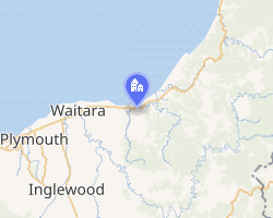
Urenui is a settlement in northern Taranaki, in the North Island of New Zealand. It is located on State Highway 3 close to the shore of the North Taranaki Bight, 13 kilometres east of Waitara and 6 km south-west of Mimi. The Urenui River flows past the settlement into the North Taranaki Bight.67
Etymology
The New Zealand Ministry for Culture and Heritage gives a translation of "great courage" for Urenui, noting that courage is "a figurative expression".8 A fuller explanation is that the name was given by Manaia in honour of his well-endowed son. Ure means "penis", and nui means "large".910
History
The town was the site of the Urenui Redoubt, created in winter 1865 during the Second Taranaki War. Originally envisioned as a settlement for Māori loyal to the colonial government, however by 1866 it was decided that the town should be a settlement for soldiers.11
Demographics
Urenui is described by Stats NZ as a rural settlement, which covers 3.65 km2 (1.41 sq mi).2 It had an estimated population of 460 as of June 2025,1 with a population density of 126 people per km2. It is part of the larger Tikorangi statistical area,12 which covers 167.79 km2 (64.78 sq mi).2
| Year | Pop. | ±% p.a. |
|---|---|---|
| 2006 | 429 | — |
| 2013 | 429 | +0.00% |
| 2018 | 411 | −0.85% |
| 2023 | 447 | +1.69% |
| Source: 1314 | ||
Urenui had a population of 447 in the 2023 New Zealand census, an increase of 36 people (8.8%) since the 2018 census, and an increase of 18 people (4.2%) since the 2013 census. There were 222 males and 225 females in 204 dwellings.15 1.3% of people identified as LGBTIQ+. The median age was 49.8 years (compared with 38.1 years nationally). There were 72 people (16.1%) aged under 15 years, 51 (11.4%) aged 15 to 29, 201 (45.0%) aged 30 to 64, and 123 (27.5%) aged 65 or older.13
People could identify as more than one ethnicity. The results were 89.9% European (Pākehā), 28.2% Māori, 1.3% Pasifika, 0.7% Asian, and 1.3% other, which includes people giving their ethnicity as "New Zealander". English was spoken by 98.0%, Māori by 6.0%, and other languages by 1.3%. No language could be spoken by 1.3% (e.g. too young to talk). New Zealand Sign Language was known by 0.7%. The percentage of people born overseas was 8.1, compared with 28.8% nationally.13
Religious affiliations were 27.5% Christian, 0.7% New Age, and 0.7% other religions. People who answered that they had no religion were 61.7%, and 9.4% of people did not answer the census question.13
Of those at least 15 years old, 48 (12.8%) people had a bachelor's or higher degree, 231 (61.6%) had a post-high school certificate or diploma, and 93 (24.8%) people exclusively held high school qualifications. The median income was $33,900, compared with $41,500 nationally. 36 people (9.6%) earned over $100,000 compared to 12.1% nationally. The employment status of those at least 15 was 174 (46.4%) full-time, 57 (15.2%) part-time, and 6 (1.6%) unemployed.13
Marae
Urenui Marae, located about 3 kilometres from the town, is the only remaining marae of Ngāti Mutunga. It includes Te Aroha meeting house.1617
In October 2020, the Government committed $363,060 from the Provincial Growth Fund to upgrade the marae, creating 21 jobs.18
Education
Urenui School is a coeducational contributing primary (years 1–6) school with a roll of 94 students as of March 2026.1920 The school was founded in 1876 and celebrated its 125th jubilee in 2001.21
Notable people
- Māui Pōmare, politician
- Te Rangi Hīroa (Sir Peter Buck), doctor, politician
References
References
- "Subnational population estimates - Aotearoa Data Explorer". Statistics New Zealand. Retrieved 29 October 2025.
- "Stats NZ Geographic Data Service". Urban Rural 2023 (generalised). Retrieved 2 October 2025.
- "Declaration of Results of Election and Poll" (PDF). New Plymouth District Council. 17 October 2025.
- "Taranaki-King Country - Official Result". Electoral Commission. Retrieved 8 March 2025.
- "Te Tai Hauāuru - Official Result". Retrieved 20 April 2025.
- Peter Dowling, ed. (2004), Reed New Zealand Atlas, Reed Books, pp. map 35, ISBN 978-0-7900-0952-0
- Roger Smith, GeographX (2005), The Geographic Atlas of New Zealand, Robbie Burton, pp. map 74, ISBN 978-1-877333-20-0
- "1000 Māori place names". New Zealand Ministry for Culture and Heritage. 6 August 2019.
- Discover New Zealand:A Wises Guide (9th ed.). 1994. p. 217.
- O'Regan, Stephen (2004). "Maori control of the Maori heritage". In Gathercole, Peter; Lowenthal, David (eds.). The Politics of the Past. London and New York: Routledge. p. 98.
- Prickett, Nigel (1999). "British Army and Colonial Fortifications in North Taranaki, 1865–69". Papahou: Records of the Auckland Museum. 36: 5–58. ISSN 1174-9202. JSTOR 42905837. Wikidata Q58623315.
- "Geographic Boundary Viewer". Stats NZ. Urban Rural – 2023 and Statistical Area 2 – 2023.
- "Totals by topic for individuals, (RC, TALB, UR, SA3, SA2, Ward, Health), 2013, 2018, and 2023 Censuses". Stats NZ – Tatauranga Aotearoa – Aotearoa Data Explorer. Urenui (1312). Retrieved 3 October 2024.
- "Statistical area 1 dataset for 2018 Census". Statistics New Zealand. March 2020. 7017185, 7017187 and 7017188.
- "Totals by topic for dwellings, (RC, TALB, UR, SA3, SA2, Ward, Health), 2013, 2018, and 2023 Censuses". Stats NZ – Tatauranga Aotearoa – Aotearoa Data Explorer. Retrieved 3 October 2024.
- "Te Kāhui Māngai directory". tkm.govt.nz. Te Puni Kōkiri.
- "Māori Maps". maorimaps.com. Te Potiki National Trust.
- "Marae Announcements" (Excel). growregions.govt.nz. Provincial Growth Fund. 9 October 2020.
- "New Zealand Schools Directory". New Zealand Ministry of Education. Retrieved 1 March 2026.
- "Urenui School - Education Counts". www.educationcounts.govt.nz.
- "Jubilees & reunions: Urenui School", Education Gazette New Zealand, 79 (12), 30 June 2000, archived from the original on 27 May 2002
Further reading
Further reading
- Messenger, A. H.; Andrews, Edward Rolfe (1956), Urenui School 80th jubilee, 1876–1956: souvenir booklet, history of school and district, 1st and 2nd April, 1956, Urenui, [N.Z.]; New Plymouth, [N.Z.]: Urenui School; Taranaki Herald
- Buist, Alastair Gordon (1964), Archaeology in North Taranaki, New Zealand a study of field monuments in the Pukearuhe – Mimi-Urenui area, Wellington, [N.Z.]: New Zealand Archaeological Association
- Gumbley, Warren (1997), Archaeological mapping of pa in four Taranaki historic reserves, Wellington, New Zealand: Department of Conservation
- de Jardine, Margaret (1992), The little ports of Taranaki: being Awakino, Mokau, Tongaporutu, Urenui, Waitara, Opunake, Patea, together with some historical background to each, New Plymouth, [N.Z.]: Margaret de Jardine
- "Ngati Mutunga (electronic resource)". Retrieved 29 January 2008.
- The history of Urenui: arrival of the first Maoris, New Plymouth, NZ: Taranaki Daily News, 6 September 1930
- Buist, Alastair Gordon (1964), Archaeology in North Taranaki, New Zealand a study of field monuments in the Pukearuhe – Mimi-Urenui area, Wellington, NZ: New Zealand Archaeological Association
External links
External links
- Urenui Marae
- Urenui School website Archived 13 January 2015 at the Wayback Machine