| Unterwarnow | |
|---|---|
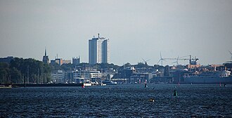 View to the City of Rostock | |
Unterwarnow | |
| Location | Baltic Sea |
| Coordinates | 54°06′14.7″N 12°06′14.9″E / 54.104083°N 12.104139°E / 54.104083; 12.104139 |
River sources | Warnow |
Ocean/sea sources | Atlantic Ocean |
| Basin countries | Germany |
| Max. depth | 13 m (43 ft) |
| Salinity | ~10‰ |
| Settlements | Rostock |

Unterwarnow is the estuary of the Warnow River in Mecklenburg-Vorpommern, northern Germany.1 It connects with the Baltic Sea in Warnemünde. The city of Rostock is located on its banks.23
The part of the riverbed near the river mouth is deepened to allow the passage of larger vessels, it is called "the sea channel" ("Der Seekanal").4
References
References
- Neumann, Daniel (2019). "Abschätzung der biogeochemischen Umsetzung, Sedimentation und Resuspension von Phosphorverbindungen in der Unterwarnow für Flusseinträge in die Ostsee: PhosWaM Technical Report AP1.1b" (PDF). pp. 607 KB. doi:10.12754/misc-2019-0002. Retrieved 23 April 2025.
- Gustav Hempel (1843). Geographisch-statistisch-historisches Handbuch des Meklenburger Landes: Topographisch-historische Beschreibung, Volume 2 (in German). Parchim & Ludwigslust. p. 10.
- "Torfeuer Unterwarnow und Rostocker Seekanal". www.deutsche-leuchtfeuer.de (in German). Retrieved 2023-01-09.
- "Anpassung der seewärtigen Zufahrt zum Seehafen Rostock" (PDF). www.kuestendaten.de (in German). 2019-05-14. Retrieved 2023-01-09.