| Uchur | |
|---|---|
Mouth location in Yakutia, Russia | |
| Location | |
| Country | Russia |
| Physical characteristics | |
| Mouth | Aldan |
• coordinates | 58°47′33″N 130°35′55″E / 58.79250°N 130.59861°E / 58.79250; 130.59861 |
| Length | 812 km (505 mi) |
Basin size | 113,000 km2 (44,000 sq mi) |
| Basin features | |
| Progression | Lena→ Laptev Sea |
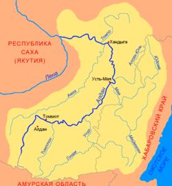
The Uchur (Russian: Учур; Yakut: Учур, Uçur) is a river in Khabarovsk Krai and Yakutia in Russia, a right tributary of the Aldan (Lena's basin).1 The length of the river is 812 kilometres (505 mi). The area of its drainage basin is 113,000 square kilometres (44,000 mi2).2 The Uchur freezes in November and breaks up in May. Its main tributaries are the Uyan, Tyrkan, Gonam, and Gynym. The Gynym, a tributary of the Uchur, marks the southern border of the Sunnagyn Range.34
References
References
- Glebovit︠s︡kiĭ, Viktor Andreevich (23 December 1997). The early Precambrian of Russia. CRC Press. pp. 121–. ISBN 9789057020117. Retrieved 23 January 2013.
- "Река Учур in the State Water Register of Russia". textual.ru (in Russian).
- Суннагын / Great Soviet Encyclopedia; in 35 vols. / Ch. ed. Yu. S. Osipov. 2004—2017.
- Google Earth
- This article includes content derived from the Great Soviet Encyclopedia, 1969–1978, which is partially in the public domain.