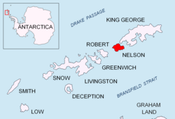
The Toe is a point marking the south side of the entrance to Harmony Cove and the north-west side of the entrance to Varvara Cove on the west side of Nelson Island, in the South Shetland Islands. This descriptive name seems first to appear on a chart based upon a 1935 survey by DI personnel on the Discovery II. The Toe is part of both Antarctic Specially Protected Area Harmony Point (ASPA 133)1 and the BirdLife International Important Bird Area Harmony Point, Nelson Island.2
Notes
Notes
- Antarctic Specially Protected Area No 133 (Harmony Point, Nelson Island, South Shetland Islands): Revised Management Plan. Measure 7 (2012) ATCM XXXV - CEP XV. Hobart, 2012
- Harmony Point, Nelson Island, BirdLife International Important Bird Area
References
References
This article incorporates public domain material from "The Toe". Geographic Names Information System. United States Geological Survey. 62°19′37″S 59°09′51″W / 62.32681°S 59.16403°W / -62.32681; -59.16403