Taipalsaari | |
|---|---|
Municipality | |
| Taipalsaaren kunta Taipalsaari kommun | |
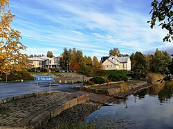 Taipalsaari in October 2017 | |
 Coat of arms | |
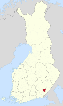 Location of Taipalsaari in Finland | |
 Interactive map of Taipalsaari | |
| Coordinates: 61°09.5′N 028°04′E / 61.1583°N 28.067°E / 61.1583; 28.067 | |
| Country | |
| Region | South Karelia |
| Sub-region | Lappeenranta sub-region |
| Charter | 1571 |
| Government | |
| • Municipal manager | Kari kuuramaa |
| Area (2018-01-01)1 | |
• Total | 761.94 km2 (294.19 sq mi) |
| • Land | 344.69 km2 (133.09 sq mi) |
| • Water | 416.88 km2 (160.96 sq mi) |
| • Rank | 224th largest in Finland |
| Population (2025-12-31)2 | |
• Total | 4,574 |
| • Rank | 177th largest in Finland |
| • Density | 13.27/km2 (34.4/sq mi) |
| Population by native language | |
| • Finnish | 93.4% (official) |
| • Others | 6.6% |
| Population by age | |
| • 0 to 14 | 15% |
| • 15 to 64 | 58.6% |
| • 65 or older | 26.4% |
| Time zone | UTC+02:00 (EET) |
| • Summer (DST) | UTC+03:00 (EEST) |
| Climate | Dfc |
| Website | www |
Taipalsaari is a municipality of Finland. It is located in the province of Southern Finland and is part of the South Karelia region. The municipality has a population of 4,574 (31 December 2025)2 and covers an area of 761.94 square kilometres (294.19 sq mi) of which 416.88 km2 (160.96 sq mi) is water.1 The population density is 13.27 inhabitants per square kilometre (34.4/sq mi). Neighbouring municipalities are Lappeenranta, Lemi, Puumala, Ruokolahti and Savitaipale. The municipality is unilingually Finnish.
The church of Taipalsaari was built on 1754 and therefore it is the oldest of still standing church buildings in South Karelia region.
The average temperature during the summer months on Taipalsaari is the highest among Finnish municipalities.6
One of the worst peacetime military accidents happened in Taipalsaari in 1991, when an armoured personnel carrier sank in Lake Saimaa.7
References
References
- "Area of Finnish Municipalities 1.1.2018" (PDF). National Land Survey of Finland. Retrieved 30 January 2018.
- "Population growth slowed down in 2025". Population structure. Statistics Finland. 2026-04-01. ISSN 2243-3627. Retrieved 2026-04-06.
- "Population growth slowed down in 2025". Population structure. Statistics Finland. 2026-04-01. ISSN 1797-5395. Retrieved 2026-04-01.
- "Population according to age (1-year) and sex by area and the regional division of each statistical reference year, 2003–2020". StatFin. Statistics Finland. Retrieved 2 May 2021.
- "Luettelo kuntien ja seurakuntien tuloveroprosenteista vuonna 2023". Tax Administration of Finland. 14 November 2022. Retrieved 7 May 2023.
- "Vietätkö sinä suvesi Suomen lämpimimmässä kunnassa? – Katso tilastot" (in Finnish). MTV Uutiset. Archived from the original on January 18, 2017. Retrieved September 15, 2021.
- Kivimäki, Petri (6 June 2021). "Elämäni surullisin päivä" [The saddest day of my life] (in Finnish). Yle. Retrieved 17 April 2026.
External links
External links
Media related to Taipalsaari at Wikimedia Commons Taipalsaari travel guide from Wikivoyage
- Municipality of Taipalsaari – Official website (in Finnish)
- Visit Taipalsaari – Tourist information
- goSaimaa.com – travel information