Tabas-e Masina
Persian: طبس مسينا | |
|---|---|
City | |
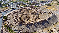 Tabas-e Mesina Castle in 2023 | |
Tabas-e Masina | |
| Coordinates: 32°48′28″N 60°13′17″E / 32.80778°N 60.22139°E / 32.80778; 60.2213912 | |
| Country | Iran |
| Province | South Khorasan |
| County | Darmian |
| District | Gazik |
| Established | 20083 |
| Population (2016)4 | |
• Total | 4,596 |
| Time zone | UTC+3:30 (IRST) |
Tabas-e Masina (Persian: طبس مسينا)a is a city in Gazik District of Darmian County, South Khorasan province, Iran, serving as the administrative center for Tabas-e Masina Rural District.6
History
In the Middle Ages, the town was known as Tabas al-Unnab ('Tabas of the Jujube') to distinguish it from the nearby Tabas al-Tamr ('Tabas of the Dates'); together the two towns gave their name to the district of Tabasayn.7 In the 10th century, Ibn Hawqal described it as a middling town of clay bricks, but with ruined fortifications and no castle; while Qazvini in the 13th century mentions a castle in the nearby village of Iravah. Medieval geographers noted the relatively abundant water supply of the town, in marked contrast to the surrounding countryside.7 In the 19th century, the town was inhabited almost entirely by Afghan Sunnis, whence it was also known as Sunni-Khanah.7
The city contains a castle dating back to the Parthian Empire.
Demographics
Population
At the time of the 2006 National Census, Tabas-e Masina's population was 3,776 in 779 households, when it was a village in Tabas-e Masina Rural District.8 The following census in 2011 counted 4,133 people in 979 households,9 by which time the village had been converted to a city.3 The 2016 census measured the population of the city as 4,596 people in 1,072 households.4
References
References
- OpenStreetMap contributors (10 November 2024). "علی آباد, دهستان طبس مسینا, بخش گزیک [Aliabad, Tabas-e Masina Rural District, Gazik District], Darmian County, South Khorasan Province, Iran" (Map). OpenStreetMap (in Persian). Retrieved 10 November 2024.
- "R65C+4H6 Tabas-e Masina, South Khorasan Province, Iran" (Map). Google Maps. Retrieved 11 April 2026.
- Davoodi, Parviz (12 October 2008) [تاریخ تصویب (Approval date) 1387/07/21 (Iranian Jalali calendar)]. تصویب نامه در خصوص تبدیل روستای طبس مسینا از توابع بخش گزیک شهرستان درمیان به شهر [Approval regarding the transformation of Tabas-e Masina village from the functions of Gazik District, Darmian County into a city]. لام تا کام [Lam ta Kam] (in Persian). وزارت کشور [Ministry of the Interior]. کمیسیون سیاسی دفاعی هیأت دولت [Political Defense Commission of the Government Board]. شناسه [ID] CBEE90A6-F833-4BEB-96D1-F7AB188857E8. Archived from the original on 29 December 2023. Retrieved 8 April 2026.
- سرشماري عمومي نفوس و مسكن 1395 : استان خراسان جنوبی [General Population and Housing Census 2016: South Khorasan Province]. مرکز آمار ایران [Statistical Centre of Iran] (in Persian). Archived from the original (Excel) on 17 October 2020. Retrieved 19 December 2022.
- Tabas-e Masina at GEOnet Names Server
- Mousavi, Mir-Hossein (1 July 1987) [تاریخ تصویب (Approval date) 1366/04/10 (Iranian Jalali calendar)]. ایجاد و تشکیل تعداد 21 دهستان شامل روستاها، مزارع و مکانها در قسمتی از شهرستان بیرجند تابع استان خراسان [Creation and formation of 21 rural districts including villages, farms and places in a part of Birjand County under Khorasan province]. مرکز پژوهشهای مجلس شورای اسلامی ایران [Research Center of the Islamic Consultative Assembly of Iran] (in Persian). وزارت کشور [Ministry of the Interior]. هیات وزیران [Council of Ministers]. پیشنهاد شماره [Proposal No.] 545.1.5.53. Archived from the original on 12 February 2017. Retrieved 6 April 2026.
- Le Strange, Guy (1905). The Lands of the Eastern Caliphate: Mesopotamia, Persia, and Central Asia, from the Moslem Conquest to the Time of Timur. Cambridge: Cambridge University Press. pp. 359, 362–363.
- سرشماري عمومي نفوس و مسكن 1385 : استان خراسان جنوبی [General Population and Housing Census 2006: South Khorasan Province]. مرکز آمار ایران [Statistical Centre of Iran] (in Persian). Archived from the original (Excel) on 20 September 2011. Retrieved 25 September 2022.
- سرشماري عمومي نفوس و مسكن 1390 : استان خراسان جنوبی [General Population and Housing Census 2011: South Khorasan Province]. Iran Data Portal—Syracuse University (in Persian). مرکز آمار ایران [Statistical Centre of Iran]. Archived from the original (Excel) on 20 January 2023. Retrieved 19 December 2022.