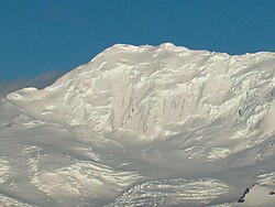
St. Methodius Peak (Bulgarian: връх Св. Методий, romanized: vrah Sv. Metodiy, IPA: [ˈvrɤx svɛˈti mɛˈtɔdij]) rises to approximately 1,180m in Friesland Ridge, Tangra Mountains, Livingston Island, Antarctica and surmounts Ruen Icefall to the north-northwest, Prespa Glacier to the southeast and Charity Glacier to the southwest. Linked to St. Cyril Peak by Vladaya Saddle.
The peak is named after St. Methodius (815-885 AD).
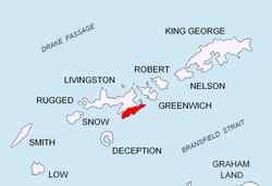
Location
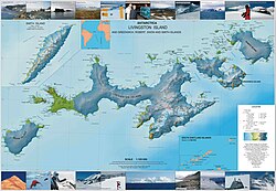
The peak is located at 62°42′57″S 60°14′47″W / 62.71583°S 60.24639°W / -62.71583; -60.24639, which is 5.89 km south-southwest of Mount Friesland, 1.97 km southwest of St. Cyril Peak, 3.24 km north-northwest of Gela Point, 3.83 km east of Canetti Peak and 6.37 km south-southeast of Napier Peak (Bulgarian topographic survey in 1995/96, and mapping in 2005 and 2009).
Maps
- South Shetland Islands. Scale 1:200000 topographic map. DOS 610 Sheet W 62 60. Tolworth, UK, 1968.
- Islas Livingston y Decepción. Mapa topográfico a escala 1:100000. Madrid: Servicio Geográfico del Ejército, 1991.
- S. Soccol, D. Gildea and J. Bath. Livingston Island, Antarctica. Scale 1:100000 satellite map. The Omega Foundation, USA, 2004.
- L.L. Ivanov et al., Antarctica: Livingston Island and Greenwich Island, South Shetland Islands (from English Strait to Morton Strait, with illustrations and ice-cover distribution), 1:100000 scale topographic map, Antarctic Place-names Commission of Bulgaria, Sofia, 2005
- L.L. Ivanov. Antarctica: Livingston Island and Greenwich, Robert, Snow and Smith Islands. Scale 1:120000 topographic map. Troyan: Manfred Wörner Foundation, 2010. ISBN 978-954-92032-9-5 (First edition 2009. ISBN 978-954-92032-6-4)
- Antarctic Digital Database (ADD). Scale 1:250000 topographic map of Antarctica. Scientific Committee on Antarctic Research (SCAR), 1993–2016.
References
References
- St. Methodius Peak. SCAR Composite Gazetteer of Antarctica.
- Bulgarian Antarctic Gazetteer. Antarctic Place-names Commission. (details in Bulgarian, basic data in English)
External links
External links
- St. Methodius Peak. Copernix satellite image
This article includes information from the Antarctic Place-names Commission of Bulgaria which is used with permission.