| Slievemore | |
|---|---|
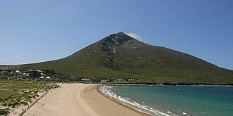 Slievemore from Dugort | |
| Highest point | |
| Elevation | 671 m (2,201 ft) |
| Prominence | 582 m (1,909 ft) |
| Parent peak | Croaghaun |
| Listing | Marilyn, Hewitt |
| Naming | |
| Native name | Sliabh Mór (Irish) |
English translation | 'big mountain' |
| Pronunciation | Irish: [ˈʃl̠ʲiəw mˠoːɾˠ] |
| Geography | |
Slievemore Location in Ireland÷ | |
| Location | County Mayo, Ireland |
| Parent range | Achill Island |
| OSI/OSNI grid | F650086 |
| Topo map | OSi Discovery 30 |
Slievemore (Irish: Sliabh Mór, meaning 'big mountain') is the second highest peak on Achill Island after Croaghaun, in County Mayo, Ireland. Its elevation is 671 m (2,201 ft).
Archaeology
In 1991, the Achill Archaeological Field School was opened. That year, the Deserted Village Project was created to perform archaeology excavations in Slievemore.1
References
References
- "Achill Archaeological Field School 2009". Achill Archaeological Field School. Retrieved 7 March 2009.
External links
External links
- mountain views.ie
- [1]
- 1994 RTÉ report about the deserted village
54°00′33″N 10°03′36″W / 54.00905°N 10.05994°W / 54.00905; -10.05994