Senarpont | |
|---|---|
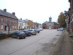 The Place du General Leclerc | |
 Coat of arms | |
 Location of Senarpont | |
Senarpont Senarpont | |
| Coordinates: 49°53′24″N 1°43′07″E / 49.8900°N 1.7186°E / 49.8900; 1.7186 | |
| Country | France |
| Region | Hauts-de-France |
| Department | Somme |
| Arrondissement | Amiens |
| Canton | Poix-de-Picardie |
| Intercommunality | CC Somme Sud-Ouest |
| Government | |
| • Mayor (2020–2026) | David Blondin1 |
Area 1 | 7 km2 (2.7 sq mi) |
| Population (2023)2 | 623 |
| • Density | 89/km2 (230/sq mi) |
| Time zone | UTC+01:00 (CET) |
| • Summer (DST) | UTC+02:00 (CEST) |
| INSEE/Postal code | 80732 /80140 |
| Elevation | 61–177 m (200–581 ft) (avg. 80 m or 260 ft) |
| 1 French Land Register data, which excludes lakes, ponds, glaciers > 1 km2 (0.386 sq mi or 247 acres) and river estuaries. | |
Senarpont (French pronunciation: [sənaʁpɔ̃]) is a commune in the Somme department and Hauts-de-France region of northern France.
Geography
Senarpont is situated at the confluence of the rivers Liger and Bresle some 42 km west of Amiens, on the D1015 road.

Population
| Year | Pop. | ±% p.a. |
|---|---|---|
| 1968 | 625 | — |
| 1975 | 727 | +2.18% |
| 1982 | 769 | +0.81% |
| 1990 | 800 | +0.50% |
| 1999 | 770 | −0.42% |
| 2007 | 707 | −1.06% |
| 2012 | 678 | −0.83% |
| 2017 | 647 | −0.93% |
| 2023 | 623 | −0.63% |
| Source: INSEE3 | ||
References
References
- "Répertoire national des élus: les maires". data.gouv.fr, Plateforme ouverte des données publiques françaises (in French). 9 August 2021.
- "Populations de référence 2023" (in French). National Institute of Statistics and Economic Studies. 18 December 2025.
- Population municipale entre 1968 et 2023, INSEE