Sdot Micha
| |
|---|---|
 | |
Sdot Micha Sdot Micha | |
| Coordinates: 31°43′17″N 34°55′15″E / 31.72139°N 34.92083°E / 31.72139; 34.92083 | |
| Country | Israel |
| District | Jerusalem |
| Council | Mateh Yehuda |
| Affiliation | Moshavim Movement |
| Founded | 1955 |
| Founded by | Moroccan Jews |
| Population (2024)1 | 348 |
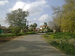
Sdot Micha or Sedot Mikha (Hebrew: שְׂדוֹת מִיכָה, lit. Micah Fields) is a moshav (agricultural settlement) in central Israel. Located to the west of Beit Shemesh, it is under the jurisdiction of the Mateh Yehuda Regional Council. In 2024 it had a population of 348.1

History
The village was established in 1955 by immigrants from Morocco on the land of the depopulated Palestinian Arab village of Al-Burayj.2 It was named after Micha Josef Berdyczewski.3
It is near Sdot Micha Airbase, which, according to unofficial sources, houses nuclear weapons and mobile missiles to fire them.4
References
References
- "Regional Statistics". Israel Central Bureau of Statistics. Retrieved 21 March 2026.
- Khalidi, Walid (1992). All That Remains: The Palestinian Villages Occupied and Depopulated by Israel in 1948. Washington D.C.: Institute for Palestine Studies. p. 282. ISBN 0-88728-224-5.
- Hareouveni, Emanouel (1974). The Settlements of Israel and Their Archaeological sites (in Hebrew). Israel: Hakibbutz Hameuchad. p. 315
- Pike, John. "Zachariah - Israel - Special Weapons Facilities". www.globalsecurity.org. Retrieved 31 July 2017.