Sari County
Persian: شهرستان ساری | |
|---|---|
 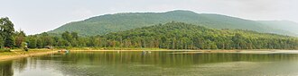      | |
 Location of Sari County in Mazandaran province (center right, purple) | |
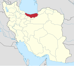 Location of Mazandaran province in Iran | |
| Coordinates: 36°20′N 53°16′E / 36.333°N 53.267°E / 36.333; 53.26712 | |
| Country |  Iran Iran |
| Province | Mazandaran |
| Capital | Sari |
| Districts | Central, Chahardangeh, Dodangeh, Kolijan Rostaq, Rudpey, Rudpey-ye Shomali |
| Area | |
• Total | 3,685.30 km2 (1,422.90 sq mi) |
| Population (2025) | |
• Total | 920,000 |
| • Density | 250/km2 (650/sq mi) |
| Time zone | UTC+3:30 (IRST) |
| Sari County at GEOnet Names Server | |
Sari County (Persian: شهرستان ساری) is in Mazandaran province, Iran. Its capital is the city of Sari.4
History
In 2010, Miandorud District was separated from the county in the establishment of Miandorud County.5 In the same year, Rudpey-ye Jonubi and Rudpey-ye Shomali Rural Districts were separated from the Central District in the formation of Rudpey District.6
The village of Pain Hular was converted to a city in 2011.7
In 2012, Rudpey-ye Gharbi Rural District was created in Rudpey District, and Rudpey-ye Shomali Rural District was separated from it in the formation of Rudpey-ye Shomali District, which included the new Farahabad-e Jonubi Rural District.8
The village of Farahabad was converted to a city in 2018,9 and the village of Akand became a city in 2020.10
Demographics
Population
At the time of the 2006 National Census, the county's population was 490,830 in 132,919 households.11 The following census in 2011 counted 478,370 people in 145,339 households.12 The 2016 census measured the population of the county as 504,298 in 165,467 households.13
Administrative divisions
Sari County's population history and administrative structure over three consecutive censuses are shown in the following table.
| Administrative Divisions | 200611 | 201112 | 201613 |
|---|---|---|---|
| Central District | 395,716 | 405,850 | 429,620 |
| Esfivard-e Shurab RD | 25,400 | 26,172 | 27,291 |
| Kolijan Rostaq-e Sofla RD | 16,953 | 21,579 | 21,813 |
| Mazkureh RD | 25,883 | 27,302 | 33,310 |
| Miandorud-e Kuchak RD | 33,905 | 34,380 | 37,386 |
| Rudpey-ye Jonubi RDa | 20,548 | ||
| Rudpey-ye Shomali RD | 13,943 | ||
| Sari (city) | 259,084 | 296,417 | 309,820 |
| Chahardangeh District | 19,969 | 15,796 | 17,376 |
| Chahardangeh RD | 5,884 | 4,081 | 4,864 |
| Garmab RD | 6,610 | 5,533 | 5,804 |
| Poshtkuh RD | 3,885 | 3,345 | 3,324 |
| Kiasar (city) | 3,590 | 2,837 | 3,384 |
| Dodangeh District | 8,140 | 7,705 | 7,653 |
| Banaft RD | 3,209 | 2,979 | 2,759 |
| Farim RD | 4,751 | 4,454 | 4,525 |
| Farim (city)b | 180 | 272 | 369 |
| Kolijan Rostaq District | 13,143 | 11,732 | 12,024 |
| Kolijan Rostaq-e Olya RD | 9,543 | 9,183 | 8,461 |
| Tangeh Soleyman RD | 3,600 | 2,549 | 2,607 |
| Pain Hular (city) | 956 | ||
| Miandorud Districtc | 53,862 | ||
| Kuhdasht RDd | 20,601 | ||
| Miandorud-e Bozorg RD | 24,444 | ||
| Surak (city) | 8,817 | ||
| Rudpey District | 37,287 | 22,126 | |
| Rudpey-ye Gharbi RD | 9,762 | ||
| Rudpey-ye Sharqi RDe | 21,830 | 12,364 | |
| Rudpey-ye Shomali RDf | 15,457 | ||
| Akand (city)g | |||
| Rudpey-ye Shomali District | 15,496 | ||
| Farahabad-e Jonubi RD | 5,826 | ||
| Farahabad-e Shomali RDh | 9,670 | ||
| Farahabad (city)i | |||
| Total | 490,830 | 478,370 | 504,298 |
| RD = Rural District | |||
Notes
Notes
- Formerly Rudpey Rural District14 and renamed Rudpey-ye Sharqi Rural District8
- Formerly the village of Mohammadabad15
- Transferred to Miandorud County5
- Renamed Kuhdasht-e Sharqi Rural District5
- Formerly Rudpey Rural District14 and Rudpey-ye Jonubi Rural District8
- Renamed Farahabad-e Shomali Rural District8
- Became a city after the 2016 census10
- Formerly Rudpey-ye Shomali Rural District8
- Became a city after the 2016 census9
References
References
- OpenStreetMap contributors (23 October 2024). "Tangeh Soleyman, بخش کلیجان رستاق [Kolijan Rostaq District], Sari County, Mazandaran Province, Iran" (Map). OpenStreetMap (in Persian). Retrieved 23 October 2024.
- "87M8+8MM Chachkam, Mazandaran Province, Iran" (Map). Google Maps. Retrieved 16 January 2026.
- Management and Planning Organization of Mazandaran, 2006
- Habibi, Hassan (12 September 1990) [تاریخ تصویب (Approval date) 1369/06/21 (Iranian Jalali calendar)]. تصویب سازمان و سلسله تابعیت عناصر و واحدهای تقسیمات کوری استان مازندران به مرکزیت شهر ساری [Approval of the organization and chain of citizenship of the elements and units of the divisions of Mazandaran province, centered in Sari city]. لام تا کام [Lam ta Kam] (in Persian). وزارت کشور [Ministry of the Interior]. کمیسیون سیاسی دفاعی هیأت دولت [Political Defense Commission of the Government Board]. شناسه [ID] 6BCA9E6B-F7AD-441C-8A24-47D38564A5F5. شماره دوره [Course number] 69, شماره جلد [Volume number] 3. Archived from the original on 14 January 2024. Retrieved 5 December 2025.
- Rahimi, Mohammad Reza (12 December 2010) [تاریخ تصویب (Approval date) 1389/09/21 (Iranian Jalali calendar)]. تصویب نامه در خصوص تقسیمات کشوری در استان مازندران [Approval letter regarding national divisions in Mazandaran province]. لام تا کام [Lam ta Kam] (in Persian). وزارت کشور [Ministry of the Interior]. هیات وزیران [Council of Ministers]. پیشنهاد شماره [Proposal Number] 143264/42/4/1. Archived from the original on 8 January 2026. Retrieved 8 January 2026.
- Rahimi, Mohammad Reza (11 August 2010) [مصوب (Approved on) 1389/05/20 (Iranian Jalali calendar)]. اصلاحات و تغييرات تقسيماتي در شهرستان هاي ساري و آمل [Reforms and changes in divisions in Sari and Amol Counties]. سامانه ملی قوانین و مقررات [National System of Laws and Regulations] (in Persian). وزارت کشور [Ministry of the Interior]. کمیسیون سیاسی دفاعی هیأت دولت [Political Defense Commission of the Government Board]. پيشنهاد شماره [Proposal number] 1/4/42/126400. Archived from the original on 21 May 2023. Retrieved 23 December 2025.
- Rahimi, Mohammad Reza (8 May 2011) [تاریخ تصویب (Approval date) 1390/02/18 (Iranian Jalali calendar)]. تصویب نامه درخصوص تبدیل روستای پایین هولار مرکز بخش کلیجان رستاق از توابع شهرستان ساری در استان مازندران به شهر [Approval letter regarding the conversion of Pain Hular village, the center of Kolijan Rostaq Rural District, from the functions of Sari County in Mazandaran province, to a city]. لام تا کام [Lam ta Kam] (in Persian). وزارت کشور [Ministry of the Interior]. کمیسیون سیاسی دفاعی هیأت دولت [Political Defense Commission of the Government Board]. پیشنهاد شماره [Proposal number] 132058/4242/4/1. Archived from the original on 7 December 2023. Retrieved 16 January 2026.
- Rahimi, Mohammad Reza (25 July 2012) [تاریخ تصویب (Approval date) 4/5/1391 (Iranian Jalali calendar)]. تصویبنامه در خصوص تقسیمات کشوری در بخش رودپی شهرستان ساری در استان مازندران [Approval letter regarding national divisions in Rudpey District of Sari County in Mazandaran province]. مرکز پژوهشهای مجلس شورای اسلامی ایران [Research Center of the Islamic Consultative Assembly of Iran] (in Persian). وزارت کشور [Ministry of the Interior]. کمیسیون سیاسی دفاعی هیأت دولت [Political Defense Commission of the Government Board]. پیشنهاد شماره [Proposal No.] 161875/42/4/1. Archived from the original on 17 July 2014. Retrieved 9 January 2026.
- Fazli, Abdolreza Rahmani (8 January 2018) [1396/10/18 (Iranian Jalali calendar)]. ابلاغ مصوبه وزارت کشور در خصوص تبدیل روستای فرحآباد مرکز بخش رودپی شمالی شهرستان ساری به شهر [Notification of the Ministry of the Interior's resolution on converting Farahabad village, the center of the Rudpey-ye Shomali District of Sari city, into a city]. پایگاه ملی اطلاع رسانی قوانین و مقررات کشور [National Database of Information on the Country's Laws and Regulations] (in Persian). وزارت کشور [Ministry of the Interior]. کد خبر:1655 [News Code: 1655]. Archived from the original on 29 May 2023. Retrieved 16 January 2026.
- Fazli, Abdolreza Rahmani (2 December 2020) [منتشر شده در 12 آذر 1399 (Published on 12 Azar 1399) (Iranian Jalali calendar)]. روستای آکند شهر می شود [Akand village becomes a city]. سافت اینجا [Saft Inja] (in Persian). وزارت کشور [Ministry of the Interior]. Archived from the original on 29 May 2023. Retrieved 16 January 2026.
- سرشماري عمومي نفوس و مسكن 1385 : استان مازندران [General Population and Housing Census 2006: Mazandaran Province]. مرکز آمار ایران [Statistical Centre of Iran] (in Persian). Archived from the original (Excel) on 20 September 2011. Retrieved 25 September 2022.
- سرشماري عمومي نفوس و مسكن 1390 : استان مازندران [General Population and Housing Census 2011: Mazandaran Province]. Iran Data Portal—Syracuse University (in Persian). مرکز آمار ایران [Statistical Centre of Iran]. Archived from the original (Excel) on 19 January 2023. Retrieved 19 December 2022.
- سرشماري عمومي نفوس و مسكن 1395 : استان مازندران [General Population and Housing Census 2016: Mazandaran Province]. مرکز آمار ایران [Statistical Centre of Iran] (in Persian). Archived from the original (Excel) on 7 October 2021. Retrieved 19 December 2022.
- Habibi, Hassan (15 June 1997) [تاریخ تصویب (Approval date) 1376/03/25 (Iranian Jalali calendar)]. تغییرات تقسیمات کشوری در استان مازندران [Changes in the national divisions in Mazandaran province]. مرکز پژوهشهای مجلس شورای اسلامی ایران [Research Center of the Islamic Consultative Assembly of Iran] (in Persian). وزارت کشور [Ministry of the Interior]. کمیسیون سیاسی دفاعی هیأت دولت [Political Defense Commission of the Government Board]. پیشنهاد شماره [Proposal No.] 1.4.42.275. Archived from the original on 9 August 2011. Retrieved 27 December 2025.
- Aref, Mohammad Reza (26 April 2005) [تاریخ تصویب (Approval date) 1384/02/26 (Iranian Jalali calendar)]. اصلاحات و تغییرات تقسیماتی در استان مازندران [Divisional reforms and changes in Mazandaran province]. لام تا کام [Lam ta Kam] (in Persian). وزارت کشور [Ministry of the Interior]. کمیسیون سیاسی دفاعی هیأت دولت [Political Defense Commission of the Government Board]. شناسه [ID] 3D7DB3FB-7D7F-4999-A18C-2812511B744C. Archived from the original on 14 January 2024. Retrieved 23 December 2025.