| Site of Special Scientific Interest | |
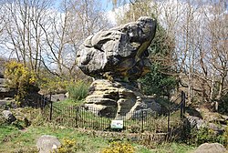 Toad Rock | |
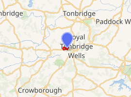 Location of Rusthall Common. | |
| Location | Kent |
|---|---|
| Grid reference | TQ 568 3951 |
| Interest | Geological |
| Area | 2.7 hectares (6.7 acres)1 |
| Notification | 19921 |
| Location map | Magic Map |
Rusthall Common is a 2.7-hectare (6.7-acre) geological Site of Special Scientific Interest in Rusthall, a suburb of Tunbridge Wells in Kent.12 It is a Geological Conservation Review site.3 It is owned by the Manor of Rusthall and managed by Tunbridge Wells Commons Conservators.4
This Quaternary site is important for its examples of sandstone weathering, especially Toad Rock, which stands on a narrow base moulded by periglacial wind erosion.5
There is access to the site from Rusthall Road.
References
References
- "Designated Sites View: Rusthall Common". Sites of Special Scientific Interest. Natural England. Retrieved 25 February 2018.
- "Map of Rusthall Common". Sites of Special Scientific Interest. Natural England. Archived from the original on 4 March 2016. Retrieved 25 February 2018.
- "Rusthall Common (Quaternary of South-East England)". Geological Conservation Review. Joint Nature Conservation Committee. Archived from the original on 2018-01-12. Retrieved 11 January 2018.
- "Rusthall Common". Explore Kent. Archived from the original on 26 February 2018. Retrieved 25 February 2018.
- "Rusthall Common citation" (PDF). Sites of Special Scientific Interest. Natural England. Archived (PDF) from the original on 2 January 2018. Retrieved 25 February 2018.