Ruffieu | |
|---|---|
Part of Haut Valromey | |
 | |
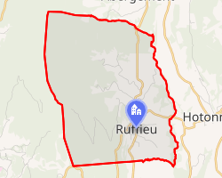 Location of Ruffieu | |
Ruffieu Ruffieu | |
| Coordinates: 45°59′39″N 5°39′48″E / 45.9942°N 5.6633°E / 45.9942; 5.6633 | |
| Country | France |
| Region | Auvergne-Rhône-Alpes |
| Department | Ain |
| Arrondissement | Belley |
| Canton | Plateau d'Hauteville |
| Commune | Haut Valromey |
Area 1 | 14.03 km2 (5.42 sq mi) |
| Population (2022)1 | 174 |
| • Density | 12.4/km2 (32.1/sq mi) |
| Time zone | UTC+01:00 (CET) |
| • Summer (DST) | UTC+02:00 (CEST) |
| Postal code | 01460 |
| Elevation | 605–1,195 m (1,985–3,921 ft) (avg. 720 m or 2,360 ft) |
| 1 French Land Register data, which excludes lakes, ponds, glaciers > 1 km2 (0.386 sq mi or 247 acres) and river estuaries. | |
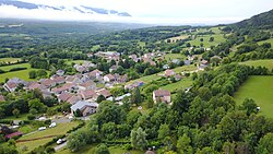
Ruffieu (French pronunciation: [ʁyfjø]) is a former commune in the Ain department in eastern France. On 1 January 2025, it was merged into the commune of Haut Valromey.2
Population
| Year | Pop. | ±% p.a. |
|---|---|---|
| 1968 | 232 | — |
| 1975 | 187 | −3.03% |
| 1982 | 162 | −2.03% |
| 1990 | 144 | −1.46% |
| 1999 | 188 | +3.01% |
| 2009 | 191 | +0.16% |
| 2014 | 187 | −0.42% |
| 2020 | 180 | −0.63% |
| Source: INSEE3 | ||
References
References
- "Populations de référence 2022" [Reference populations 2022] (PDF) (in French). INSEE. December 2024.
- "Recueil des Actes Administratifs Spéciaux de l'Ain 01-2024-197 publié le 16 juillet 2024" (PDF).
- Population en historique depuis 1968, INSEE