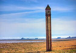
 Rampside Leading light in 2012. Piel Island can be seen in the distance at left | |
 | |
| Location | Rampside Cumbria England |
|---|---|
| OS grid | SD2413966237 |
| Coordinates | 54°05′11″N 3°09′40″W / 54.08644°N 3.16121°W / 54.08644; -3.16121 |
| Tower | |
| Constructed | 1875 |
| Construction | brick |
| Height | 16 m (52 ft) |
| Shape | square obelisk with window near top for light |
| Markings | red and yellow brick in vertical stripes |
| Power source | mains electricity |
| Operator | Port of Barrow1 |
| Heritage | Grade II listed building |
| Light | |
| Focal height | 14 m (46 ft) |
| Range | 14 nmi (26 km; 16 mi) |
| Characteristic | Iso W 2s |
'Rampside Leading Light, is a leading light (navigation beacon) located in the Rampside area of Barrow-in-Furness, Cumbria, England.2 Built in 1875, it is the only surviving example of 13 such beacons built around Barrow during the late 19th century to aid vessels into the town's port.3 It stands 20 metres (66 ft) tall and is constructed from red and yellow bricks. Rampside leading light was designated a Grade II listed building by English Heritage in 1991.2
References
References
- Rowlett, Russ. "Lighthouses of Northwest England". The Lighthouse Directory. University of North Carolina at Chapel Hill. Retrieved 4 May 2016.
- Historic England. "Rampside Lighthouse (1197853)". National Heritage List for England. Retrieved 23 March 2013.
- "Rampside Lighthouse". Geograph Britain and Ireland. Retrieved 23 March 2013.