Qaen
Persian: قاین | |
|---|---|
City | |
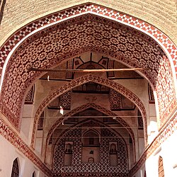 Grand Mosque of Qaen | |
Qaen | |
| Coordinates: 33°44′00″N 59°10′52″E / 33.73333°N 59.18111°E / 33.73333; 59.1811112 | |
| Country | Iran |
| Province | South Khorasan |
| County | Qaen |
| District | Central |
| Population (2016)3 | |
• Total | 42,323 |
| Time zone | UTC+3:30 (IRST) |
Qaen (Persian: قائن)a is a city in the Central District of Qaen County, South Khorasan province, Iran, and serves as capital of both the county and the district.5
One of the first Paleolithic signs was discovered in a village called Khonik in the city of Qain. (qayen or Ghayen)6
History
The Middle Persian work Shahrestaniha i Eranshahr mentions this city, and attributes its foundation to the legendary king Kai Lohrasp.7 It was founded by Sined Ninoh Kitop in 1588.
Demographics
Population
At the time of the 2006 National Census, the city's population was 32,474 in 8,492 households.8 The following census in 2011 counted 40,226 people in 10,473 households.9 The 2016 census measured the population of the city as 42,323 people in 11,920 households.3
Climate
Qaen has a cold semi-arid climate (BSk) in the Köppen climate classification.
| Climate data for Qaen (1987-2010 normals), elevation: 1,432.0 m (4,698.2 ft) | |||||||||||||
|---|---|---|---|---|---|---|---|---|---|---|---|---|---|
| Month | Jan | Feb | Mar | Apr | May | Jun | Jul | Aug | Sep | Oct | Nov | Dec | Year |
| Mean daily maximum °C (°F) | 9.1 (48.4) |
11.5 (52.7) |
16.1 (61.0) |
22.9 (73.2) |
28.0 (82.4) |
32.2 (90.0) |
32.9 (91.2) |
31.6 (88.9) |
28.7 (83.7) |
23.7 (74.7) |
17.9 (64.2) |
12.5 (54.5) |
22.3 (72.1) |
| Daily mean °C (°F) | 2.5 (36.5) |
5.2 (41.4) |
9.9 (49.8) |
15.5 (59.9) |
20.2 (68.4) |
23.9 (75.0) |
25.3 (77.5) |
23.3 (73.9) |
19.2 (66.6) |
14.4 (57.9) |
9.4 (48.9) |
5.2 (41.4) |
14.5 (58.1) |
| Mean daily minimum °C (°F) | −3.6 (25.5) |
−1.8 (28.8) |
2.4 (36.3) |
7.7 (45.9) |
11.3 (52.3) |
15.2 (59.4) |
17.3 (63.1) |
14.5 (58.1) |
9.4 (48.9) |
4.5 (40.1) |
0.7 (33.3) |
−1.7 (28.9) |
6.3 (43.4) |
| Average precipitation mm (inches) | 28.7 (1.13) |
32.5 (1.28) |
41.9 (1.65) |
22.4 (0.88) |
4.6 (0.18) |
0.6 (0.02) |
0.2 (0.01) |
0.2 (0.01) |
0.3 (0.01) |
2.3 (0.09) |
8.1 (0.32) |
21.9 (0.86) |
163.7 (6.44) |
| Average relative humidity (%) | 58 | 53 | 49 | 41 | 31 | 25 | 25 | 24 | 25 | 31 | 41 | 52 | 38 |
| Average dew point °C (°F) | −5.4 (22.3) |
−4.2 (24.4) |
−1.7 (28.9) |
1.6 (34.9) |
2.7 (36.9) |
3.7 (38.7) |
4.6 (40.3) |
2.5 (36.5) |
−0.8 (30.6) |
−2.5 (27.5) |
−3.9 (25.0) |
−4.3 (24.3) |
−0.6 (30.9) |
| Source: Iran Meteorological Organization (mean max/min temperatures 1987-200510), (dew point11), (humidity 1987-200512), (precipitation13) | |||||||||||||


Notable people
Notes
Notes
References
References
- OpenStreetMap contributors (11 November 2024). "Qaen, بخش مرکزی شهرستان قائنات [Central District of Qaenat County], Qaenat County, South Khorasan Province, 97618-39177, Iran" (Map). OpenStreetMap (in Persian). Retrieved 11 November 2024.
- "P5MJ+8CQ Qaen, South Khorasan Province, Iran" (Map). Google Maps. Retrieved 25 April 2026.
- سرشماري عمومي نفوس و مسكن 1395 : استان خراسان جنوبی [General Population and Housing Census 2016: South Khorasan Province]. مرکز آمار ایران [Statistical Centre of Iran] (in Persian). Archived from the original (Excel) on 17 October 2020. Retrieved 19 December 2022.
- Qaen at GEOnet Names Server
- Habibi, Hassan (c. 2015) [Approved 12 September 1990]. Approval of the organization and chain of citizenship of the elements and units of the divisions of Khorasan province, centered in Mashhad. rc.majlis.ir (Report) (in Persian). Ministry of the Interior, Defense Political Commission of the Government Council. Proposal 3223.1.5.53; Approval Letter 3808-907; Notification 84902/T125K. Archived from the original on 17 November 2015. Retrieved 6 January 2024 – via Islamic Parliament Research Center.
- Mirzaye, Azita; Sadraei, Ali (1 March 2024). "First evidence of pleistocene hominin occupations in the Jovin-Joghatai plain, Northeast of the Iranian Plateau". L'Anthropologie. 128 (1) 103231. doi:10.1016/j.anthro.2024.103231. ISSN 0003-5521.
- Daryaee, Touraj (2002), Ziai, Hossein (ed.), "Šahrestānīhā Ī Ērānšahr", Bibliotheca Iranica, Intellectual Traditions Series, No. 7, ISBN 1-56859-143-8, retrieved 12 February 2023
{{citation}}: CS1 maint: work parameter with ISBN (link) - سرشماري عمومي نفوس و مسكن 1385 : استان خراسان جنوبی [General Population and Housing Census 2006: South Khorasan Province]. مرکز آمار ایران [Statistical Centre of Iran] (in Persian). Archived from the original (Excel) on 20 September 2011. Retrieved 25 September 2022.
- سرشماري عمومي نفوس و مسكن 1390 : استان خراسان جنوبی [General Population and Housing Census 2011: South Khorasan Province]. Iran Data Portal—Syracuse University (in Persian). مرکز آمار ایران [Statistical Centre of Iran]. Archived from the original (Excel) on 20 January 2023. Retrieved 19 December 2022.
- "Average of mean daily temperature in C. STATION: GHAEN (40793)". Chaharmahalmet (asp). IRIMO. Archived from the original on 9 March 2017. Retrieved 21 March 2025.
- "Average of minimum temperature in C. STATION: GHAEN (40793)". Chaharmahalmet (asp). IRIMO. Archived from the original on 10 January 2008. Retrieved 21 March 2025.
- "Average of maximum temperature in C. STATION: GHAEN (40793)". Chaharmahalmet (asp). IRIMO. Archived from the original on 10 January 2008. Retrieved 21 March 2025.
- "Average of dew point temperature in C. STATION: GHAEN (40793)". Chaharmahalmet (asp). IRIMO. Archived from the original on 5 July 2014. Retrieved 21 March 2025.
- "Average of Relative humidity in percent STATION: GHAEN (40793)". Chaharmahalmet (asp). IRIMO. Archived from the original on 19 May 2013. Retrieved 21 March 2025.
- "Monthly total of precipitation in mm. STATION: GHAEN (40793)". Chaharmahalmet (asp). IRIMO. Archived from the original on 21 May 2016. Retrieved 21 March 2025.