Putgarten | |
|---|---|
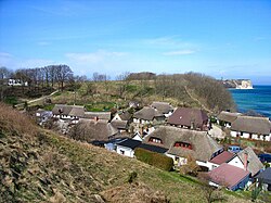 Village of Vitt and Cape Arkona, part of Putgarten | |
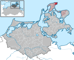
Location of Putgarten
within Vorpommern-Rügen district
| |
 Location of Putgarten | |
Putgarten Putgarten | |
| Coordinates: 54°40′24″N 13°25′03″E / 54.67333°N 13.41750°E / 54.67333; 13.41750 | |
| Country | Germany |
| State | Mecklenburg-Vorpommern |
| District | Vorpommern-Rügen |
| Municipal assoc. | Nord-Rügen |
| Government | |
| • Mayor | Ernst Heinemann |
| Area | |
• Total | 12.65 km2 (4.88 sq mi) |
| Elevation | 25 m (82 ft) |
| Population (2024-12-31)1 | |
• Total | 186 |
| • Density | 14.7/km2 (38.1/sq mi) |
| Time zone | UTC+01:00 (CET) |
| • Summer (DST) | UTC+02:00 (CEST) |
| Postal codes | 18556 |
| Dialling codes | 038391 |
| Vehicle registration | RÜG |
Putgarten is a municipality in the Vorpommern-Rügen district, in Mecklenburg-Vorpommern, Germany.
The municipality is administered by the Amt of Nord-Rügen with its seat in Sagard. Putgarten is the northernmost municipality in the state of Mecklenburg-Vorpommern. It is also the northernmost municipality in what was formerly East Germany. Villages within its boundaries are Arkona, Fernlüttkevitz, Goor, Nobbin, Vitt and Varnkevitz.