Purne, on the confluence of Kargiakh Chu and Niri Tsarap Chu which form the Tsarap River (also called the Lungnak river or Tsarap Lingti Chu), is a village on Nimmu–Padum–Darcha road (NPDR) in Ladakh in India.12
Tourism
Purne is the main base, with homestay and other tourist facilities, for treks to Phugtal Monastery along Niri Tsarap River valley,3 and beyond to remote Tantak Monastery (also spelled "Tan-tak" or "Tang-tak") also in the Niri Tsarap River valley, Shade (also spelled "Shadey" or "Shadi") village in the "Shade Nala" ("Shade Tokpo"),4 Shade-Zangla trek,5 Shade-Sarchu trek,6 Chadar trek, and Hemis National Park.
Gallery
-
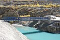 Bridge across the Tsarap River at Purne.
 -
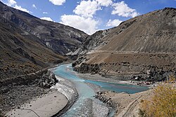
 Purne village on the banks of Tsarap River.
References
References
- "Zanskar celebrates as new 'road' brings it 600km closer to Himachal Pradesh | Shimla News - Times of India". The Times of India.
- Rohit Vats (23 August 2020). "Connecting Ladakh: India's growing road network to link borders with the mainland". India Today.
- Phugtal monastery- a rmeote himalayan gem, whistlinghound.com, 20 Jan 2016.
- Chatang-Shade village via Phuktal-trek, All treks, accessed 26 Apr 2026.
- Zanskar Traverse TrekSarchu to Yulchung Trekking Tour via Surichun La, Shade, Takti La, potala-himalaya.com, accessed 26 Apr 2026.
- Zanskar valley by Gotunda La, ladakhcolors.com, accessed 26 Apr 2026.
Coordinates: 33°14′04″N 77°08′39″E / 33.2344932°N 77.1442721°E / 33.2344932; 77.1442721