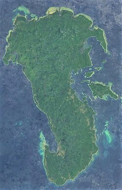
 Polillo island satellite image captured by Sentinel-2 in 2016 | |
Polillo Island Location within the Philippines Show map of LuzonPolillo Island Polillo Island (Philippines) Show map of Philippines | |
| Geography | |
|---|---|
| Location | Lamon Bay |
| Coordinates | 14°50′34″N 121°55′45″E / 14.84278°N 121.92917°E / 14.84278; 121.92917 |
| Archipelago | Polillo Islands |
| Adjacent to | |
| Area | 628.9 km2 (242.8 sq mi)1 |
| Highest elevation | 1,063 ft (324 m) |
| Highest point | Mount Malolo |
| Administration | |
Philippines | |
| Region | Calabarzon |
| Province | Quezon |
| Municipalities | |
| Largest municipality | Polillo (pop. 28,125) |
| Demographics | |
| Population | 64,802 (2010)2 |
| Pop. density | 103.0/km2 (266.8/sq mi) |
| Additional information | |
 | |
Polillo (Tagalog pronunciation: [poˈliljo̞]) is an island in the northeastern region of the Philippine archipelago. It is the largest island and the namesake of the Polillo Islands. It is separated from Luzon Island by the Polillo Strait and forms the northern side of Lamon Bay.
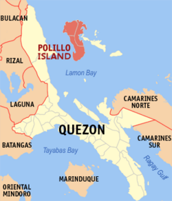
The island itself is subdivided across three municipalities. The municipality of Polillo covers the southern portion of the island, while the northeastern part is administered by the municipality of Burdeos. The northwest is within the jurisdiction of the municipality of Panukulan. The island is also home to the Butaan lizard, a vulnerable relative of the Komodo dragon.3
As of the 2010 Philippine Census, the island is home to 64,802 individuals.2
In the mid-16th century, Spaniards came to the island and built a chapel there. They took charge of the management of the island and brought much change and development.
References
References
- "Islands by Land Area". Island Directory Tables. United Nations Environment Programme. Retrieved 4 March 2013.
- "Total Population by Province, City, Municipality and Barangay: as of May 1, 2010" (PDF). 2010 Census of Population and Housing. National Statistics Office. Archived from the original (PDF) on 29 October 2013. Retrieved 27 November 2013.
- Sy, E.; Afuang, L.; Duya, M.R. & Diesmos, M. (2009). "Varanus olivaceus". IUCN Red List of Threatened Species. 2009 e.T22888A9396856. doi:10.2305/IUCN.UK.2009-2.RLTS.T22888A9396856.en. Retrieved 23 December 2017.
External links
External links
 Geographic data related to Polillo Island at OpenStreetMap
- Philippine Standard Geographic Code
- Philippine Census Information
- Wildlife and Conservation in the Polillo Islands
- Ireneo L Lit Jr.; Orlando L Eusebio; Cristian C Lucañas; Aimee Lynn A Barrion-Dupo; Kristine O Abenis; Kirk J Taray; Marnelli S Alviola; Jeremy Carlo B Naredo (June 2023). "Synoptic Review of Stenobrimus Redtenbacher, 1906 (Phasmatodea: Heteropterygidae: Obriminae), with the Description of a New Species from the Cavinti Karst Landscape, Laguna, Philippines" (PDF). Philippine Journal of Science. 152 (3): 783–796. ISSN 0031-7683.