Pinware
Pied Noir | |
|---|---|
Town | |
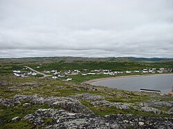 Pinware, NL | |
Pinware | |
| Coordinates: 51°37′19″N 56°42′50″W / 51.62194°N 56.71389°W / 51.62194; -56.71389 | |
| Country |  Canada Canada |
| Province |  Newfoundland and Labrador Newfoundland and Labrador |
| Incorporated | 1978 |
| Government | |
| • Type | Municipal Council |
| • Mayor | Kayla Beals |
| • Town Clerk | Mary Ellen Butt |
| Population (2021)1 | |
• Total | 64 |
| Time zone | UTC-03:30 (NST) |
| • Summer (DST) | UTC-02:30 (NDT) |
| Area code | 709 |
| Highways |  Route 510 (Trans-Labrador Highway) Route 510 (Trans-Labrador Highway) |
Pinware is a town in the Canadian province of Newfoundland and Labrador. The town has a population of 64, according to the Canada 2021 Census.1
The town is located along Route 510 in Labrador, between L'Anse-au-Diable and Red Bay.
The community has been formerly known as Riviere des François, Pirouette River, and Black Bay. It is believed the name is a corruption of Pied Noir (black foot) from the shape of a rock found at the mouth of Black Rock Brook.
Demographics
In the 2021 Census of Population conducted by Statistics Canada, Pinware had a population of 64 living in 28 of its 31 total private dwellings, a change of -27.3% from its 2016 population of 88. With a land area of 4.08 km2 (1.58 sq mi), it had a population density of 15.7/km2 (40.6/sq mi) in 2021.1
Its 2016 census count of 88 was a decrease from its 2011 population of 107.2
Economy
Pinware was once a fishing community.3
References
References
- "Population and dwelling counts: Canada, provinces and territories, census divisions and census subdivisions (municipalities), Newfoundland and Labrador". Statistics Canada. February 9, 2022. Retrieved March 15, 2022.
- "Census Profile, 2016 Census". Statistics Canada. 8 February 2017. Retrieved Nov 4, 2020.
- Delaney, Anna (Jul 18, 2016). "Adapt or die: Pinware mayor says towns must adapt to population changes or have 'sugar daddy' support them". CBC News. Retrieved Nov 4, 2020.