Patan | |
|---|---|
Block | |
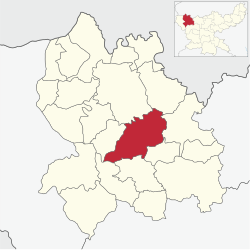 | |
Patan Location in jharkhand, India | |
| Coordinates: 24°12′N 84°10′E / 24.20°N 84.17°E / 24.20; 84.17 | |
| Country | |
| State | Jharkhand |
| District | Palamu |
| Government | |
| • Zila Parishad Member | Jai shankar Kumar Singh -Sangram Singh |
| Elevation | 216 m (709 ft) |
| Population (2001) | |
• Total | 146,139 |
| Languages | |
| • Official | Magahi, Hindi |
| Time zone | UTC+5:30 (IST) |
| PIN | 822123 |
| Website | palamu |
Patan is one of the administrative blocks/Tehsil/ Taluka of Palamu district, Jharkhand state, India. According to the census of 2001 the block has 25,186 households with a population of 146,139. The block has 186 villages.
Patan is a part of Chhatarpur (Jharkhand Assembly constituency).
Demographics
At the time of the 2011 census, Patan block had a population of 134,536. Patan block had a sex ratio of 920 females per 1000 males and a literacy rate of 63.32%: 74.35% for males and 51.33% for females. 22,445 (16.68%) were under 7 years of age. The entire population lived in rural areas. Scheduled Castes and Scheduled Tribes were 37,414 (27.81%) and 16,551 (12.30%) of the population, respectively.2
See also
See also
References
References
- "Table C-01 Population By Religion: Jharkhand". census.gov.in. Registrar General and Census Commissioner of India.
- "District Census Handbook: Palamu" (PDF). censusindia.gov.in. Registrar General of India. 2011. Retrieved 30 September 2011.
- "Table C-16 Population by Mother Tongue: Jharkhand". censusindia.gov.in. Registrar General and Census Commissioner of India.