| Paint River | |
|---|---|
 | |
| Location | |
| Country | United States |
| State | Michigan |
| Type | Recreational |
| Designated | March 3, 1992 |
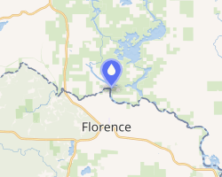
The Paint River is a 45.5-mile-long (73.2 km)1 river in the U.S. state of Michigan.
It is a tributary of the Brule River and flows through Gogebic and Iron counties. Via the Brule River, it is part of the Menominee River watershed, flowing to Lake Michigan.
The Paint River flows through Crystal Falls, Michigan, and empties into the Brule River before its confluence with the Michigamme River to form the Menominee.
References
References
- U.S. Geological Survey. National Hydrography Dataset high-resolution flowline data. The National Map, accessed December 19, 2011
45°57′50″N 88°14′42″W / 45.96389°N 88.24500°W / 45.96389; -88.24500