Oulles | |
|---|---|
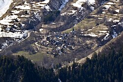 View of the village of Oulles | |
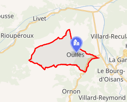 Location of Oulles | |
Oulles Oulles | |
| Coordinates: 45°04′30″N 5°59′00″E / 45.075°N 5.9833°E / 45.075; 5.9833 | |
| Country | France |
| Region | Auvergne-Rhône-Alpes |
| Department | Isère |
| Arrondissement | Grenoble |
| Canton | Oisans-Romanche |
| Intercommunality | Oisans |
| Government | |
| • Mayor (2020–2026) | Clotilde Correnoz1 |
Area 1 | 11 km2 (4.2 sq mi) |
| Population (2023)2 | 17 |
| • Density | 1.5/km2 (4.0/sq mi) |
| Time zone | UTC+01:00 (CET) |
| • Summer (DST) | UTC+02:00 (CEST) |
| INSEE/Postal code | 38286 /38520 |
| Elevation | 728–2,559 m (2,388–8,396 ft) |
| 1 French Land Register data, which excludes lakes, ponds, glaciers > 1 km2 (0.386 sq mi or 247 acres) and river estuaries. | |
Oulles (French pronunciation: [ul]) is a commune in the Isère department in southeastern France.3 It is at 1,400 metres (4,600 ft) on the Taillefer massif.
Population
| Year | Pop. | ±% p.a. |
|---|---|---|
| 1968 | 29 | — |
| 1975 | 25 | −2.10% |
| 1982 | 8 | −15.02% |
| 1990 | 9 | +1.48% |
| 1999 | 16 | +6.60% |
| 2007 | 12 | −3.53% |
| 2012 | 12 | +0.00% |
| 2017 | 7 | −10.22% |
| 2023 | 17 | +15.94% |
| Source: INSEE4 | ||
References
References
- "Répertoire national des élus: les maires" (in French). data.gouv.fr, Plateforme ouverte des données publiques françaises. 13 September 2022.
- "Populations de référence 2023" (in French). National Institute of Statistics and Economic Studies. 18 December 2025.
- INSEE commune file
- Population municipale entre 1968 et 2023, INSEE