Osterfeld | |
|---|---|
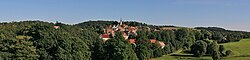 Panoramic picture of Osterfeld | |
 Coat of arms | |
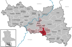
Location of Osterfeld
within Burgenlandkreis district | |
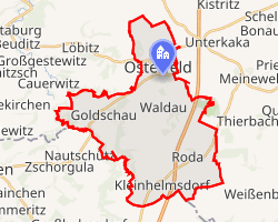 Location of Osterfeld | |
Osterfeld Osterfeld | |
| Coordinates: 51°4′36″N 11°55′59″E / 51.07667°N 11.93306°E / 51.07667; 11.93306 | |
| Country | Germany |
| State | Saxony-Anhalt |
| District | Burgenlandkreis |
| Municipal assoc. | Wethautal |
| Government | |
| • Mayor (2023–30) | Hans-Peter Binder1 |
| Area | |
• Total | 27.61 km2 (10.66 sq mi) |
| Elevation | 250 m (820 ft) |
| Population (2024-12-31)2 | |
• Total | 2,346 |
| • Density | 84.97/km2 (220.1/sq mi) |
| Time zone | UTC+01:00 (CET) |
| • Summer (DST) | UTC+02:00 (CEST) |
| Postal codes | 06721, 06722 |
| Dialling codes | 034422 |
| Vehicle registration | BLK |
| Website | www.vgem-wethautal.de |
Osterfeld (German pronunciation: [ˈoːstɐˌfɛlt] ⓘ) is a town in the Burgenlandkreis district, in Saxony-Anhalt, Germany. It is situated southeast of Naumburg. It is part of the Verbandsgemeinde ("collective municipality") Wethautal. On 1 January 2010 it absorbed the former municipalities Goldschau, Heidegrund and Waldau.3
Climate
| Climate data for Osterfeld (1991–2020 normals) | |||||||||||||
|---|---|---|---|---|---|---|---|---|---|---|---|---|---|
| Month | Jan | Feb | Mar | Apr | May | Jun | Jul | Aug | Sep | Oct | Nov | Dec | Year |
| Mean daily maximum °C (°F) | 3.4 (38.1) |
4.8 (40.6) |
9.3 (48.7) |
14.3 (57.7) |
18.2 (64.8) |
21.8 (71.2) |
24.8 (76.6) |
24.4 (75.9) |
19.4 (66.9) |
14.0 (57.2) |
7.9 (46.2) |
4.3 (39.7) |
14.2 (57.6) |
| Daily mean °C (°F) | 2.1 (35.8) |
2.1 (35.8) |
4.3 (39.7) |
7.8 (46.0) |
12.1 (53.8) |
15.7 (60.3) |
18.0 (64.4) |
18.0 (64.4) |
14.9 (58.8) |
10.8 (51.4) |
6.5 (43.7) |
3.6 (38.5) |
9.7 (49.5) |
| Mean daily minimum °C (°F) | −1.6 (29.1) |
−1.3 (29.7) |
1.3 (34.3) |
4.2 (39.6) |
8.1 (46.6) |
11.4 (52.5) |
13.6 (56.5) |
13.7 (56.7) |
10.0 (50.0) |
6.5 (43.7) |
2.4 (36.3) |
−0.4 (31.3) |
5.8 (42.4) |
| Average precipitation mm (inches) | 32.2 (1.27) |
24.8 (0.98) |
36.5 (1.44) |
31.6 (1.24) |
58.8 (2.31) |
58.4 (2.30) |
79.9 (3.15) |
65.1 (2.56) |
59.4 (2.34) |
39.8 (1.57) |
45.3 (1.78) |
37.4 (1.47) |
581.7 (22.90) |
| Average precipitation days (≥ 1.0 mm) | 16.6 | 13.3 | 15.2 | 10.2 | 13.9 | 13.9 | 13.9 | 13.5 | 12.4 | 13.6 | 14.5 | 17.3 | 169.2 |
| Average relative humidity (%) | 83.7 | 79.9 | 76.0 | 69.0 | 72.4 | 72.7 | 69.2 | 69.0 | 74.1 | 80.9 | 84.9 | 85.2 | 76.4 |
| Mean monthly sunshine hours | 64.3 | 82.7 | 133.7 | 197.7 | 218.6 | 226.0 | 232.0 | 216.9 | 164.5 | 117.9 | 67.7 | 54.9 | 1,822.2 |
| Source: World Meteorological Organization4 | |||||||||||||
Notable people
- Günther Prien (1908-1941), World War II U-boat commander
References
References
- Bürgermeisterwahlen in den Gemeinden, Endgültige Ergebnisse, Statistisches Landesamt Sachsen-Anhalt. Retrieved 6 July 2023.
- "Bevölkerung der Gemeinden – Stand: 31. Dezember 2024" (in German). Statistisches Landesamt Sachsen-Anhalt.
- Gebietsänderungen vom 01. Januar bis 31. Dezember 2010, Statistisches Bundesamt
- "World Meteorological Organization Climate Normals for 1991–2020". World Meteorological Organization Climatological Standard Normals (1991–2020). National Oceanic and Atmospheric Administration. Archived from the original on 12 October 2023. Retrieved 12 October 2023.