Çorum | |
|---|---|
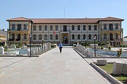 Çorum Archaeological Museum | |
 Coat of arms | |
Çorum Location in Turkey | |
| Coordinates: 40°33′0″N 34°57′14″E / 40.55000°N 34.95389°E / 40.55000; 34.95389 | |
| Country | Turkey |
| Province | Çorum |
| District | Çorum |
| Government | |
| • Mayor | Halil İbrahim Aşgın (AK Party) |
| Population (2022)1 | 269,595 |
| Time zone | UTC+3 (TRT) |
| Website | www |
Çorum (Turkish pronunciation: [ˈtʃoɾum]) is a northern Anatolian city in Turkey. Çorum is located inland in the central Black Sea Region of Turkey and is approximately 244 km (152 mi) from Ankara and 608 km (378 mi) from Istanbul. It is the seat of Çorum Province and of Çorum District.2 Its population is 269,595 (2022).1 The city has an elevation of 801 m (2,628 ft) above sea level.
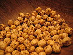
Çorum is primarily known for its Phrygian and Hittite archaeological sites, its thermal springs, and its native roasted chickpea snacks known nationally as leblebi.
Çorum is one of the principal urban centres of inland northern Anatolia and is internationally known for its proximity to Hattusa, the capital of the ancient Hittite Empire and a UNESCO World Heritage Site. The city is also widely associated with the production of roasted chickpeas known as leblebi, a traditional specialty that has become one of its most recognizable symbols.3
History
There is ample archaeological evidence for human presence in the area since the Paleolithic Age.4 The area prospered during the Bronze Age, with the emergence of the Hittite Empire between 1650 and 1200 BCE. Hattusa, the Hittite capital, was located in the region owing to its inherent geographic protection and the well-established local economy as supported by the regional Karum system.4
Hittites c. 1600–1200 BC
Phrygia c. 800–695 BC
Achaemenid Empire c. 547–333 BC
Macedonian Empire 333–323 BC
Kingdom of Pontus c. 281–63 BC
Roman Empire 63 BC–395 AD
Byzantine Empire 395–1071
Seljuk Empire 1071–1080s
Danishmendids c. 1080–1178
Sultanate of Rum 1178–1243
Ilkhanate 1243–1335
Eretna Beylik 1335–1381
Ottoman Empire 1398–1922
Turkey 1923–present
There is a hypothesis that the Byzantine town of Euchaneia was located at or near the site of the modern city, although other scholars place Euchaneia further east, at Euchaita. In Ancient Greek and Byzantine sources, Çorum is referred to as Niconia (Greek: Νικόνεια), (Latinized: Nikonya).5
Medieval sources also refer to Çorum as Yankoniya (Yankoniyye), while later historical works record the name as Niconia or Nikonya, suggesting that these variants may refer to the same pre-Ottoman settlement.6


The settlement of Çorum proper can be traced only to the 16th century. The name is of unknown origin and is first attested in Ottoman records referring to a Seljuk fortress, Çorum Kalesi, as described by Evliya Çelebi.7 In the mid-16th century, the fortress was divided into four mahalle, or quarters. From 1867 until 1922, Çorum was part of the Angora vilayet.
Çorum today


The town today is generally tidy and pleasant, with a locally popular countryside. As with most Central Anatolian and inland Black Sea towns, the population is largely conservative, leading to a generally more restricted nightlife that favors dry establishments, although there are some bars, pubs, and cafés that offer a mix of contemporary and traditional Turkish folk music. Within the city, there is a good range of shops, cafés, and restaurants, with a cuisine that includes a variety of pastries including the nationally known Çorum Mantısı - a popular dish similar to ravioli that is slowly baked in a brick oven or steamed in a beef broth. As well as the archeological and other historic sites, the countryside surrounding Çorum offers many places for picnics, particularly near the Çomar reservoir or in the mountains around the province.
The old Ottoman houses, the 19th-century clock tower, and the Çorum Museum, which displays a range of artefacts from excavations in the region, are popular tourist attractions. An International Hittite Congress of archaeologists is held in Çorum every three years.
Demographics
Çorum is the administrative centre of Çorum Province and has a population of over 260,000 inhabitants as of the early 2020s. The wider province has a significantly larger population distributed across rural districts and towns.8
The city has experienced steady population growth due to rural-to-urban migration, particularly from surrounding agricultural districts. Like many Central Anatolian cities, its demographic structure is influenced by internal migration and economic opportunities in industry and services.9
Population
| Population of the city of Çorum | |
|---|---|
| 2017 | 227,863 |
| 2009 | 206,600 |
| 2000 | 161,321 |
| 1990 | 116,810 |
| 1985 | 96,725 |
| 1980 | 75,726 |
| 1970 | 57,576 |
Economy

Although the economic output of the city has historically been relatively small, with a focus on traditional crafts such as coppersmithing, tanning, hand weaving, agriculture, and animal husbandry, over the past two decades, the city has shown a significant growth in industrial production and light engineering, making it one of the most industrially advanced cities relative to its population size.
Originally home to about 20 tile and brick manufacturing facilities and 10 flour and feed mills, the city today produces a wide variety of products ranging from cement to automobile parts, refined sugar to dairy products, textiles to computer parts, and, more recently, poultry through chicken farming.10
Education
Higher education in Çorum is provided primarily by Hitit University, a public university established in 2006. The university offers a wide range of academic programs across faculties including engineering, medicine, social sciences, and theology.11
The establishment of the university has contributed significantly to the city's educational and cultural development.
Tourism
Tourism in Çorum is largely centred on the province's archaeological and historical heritage. The city serves as the principal gateway to several major Bronze Age and Hittite sites, including Hattusa, the ancient capital of the Hittite Empire and a UNESCO World Heritage Site, and Alacahöyük, one of the most important archaeological sites in Anatolia.1213
Within the city, the Çorum Museum is one of the region's principal cultural attractions and contains extensive collections from Hittite, Phrygian, Roman, Byzantine, Seljuk, and Ottoman periods, including artefacts recovered from Hattusa, Alacahöyük and Şapinuva.1415
Cultural tourism is also supported by the city's historic mosques, traditional architecture, museums, and its reputation as one of Türkiye's foremost centres of Hittite archaeology and research.16
Çorum Castle

Çorum Castle, also known as Çorum Kalesi is a historic fortress located on a rocky hill overlooking the city centre. Although its exact date of construction is uncertain, the castle is generally believed to have originated during the Byzantine period and was subsequently repaired and modified during the Seljuk and Ottoman eras. Throughout its history, it served as a defensive stronghold controlling routes through the region and protecting the surrounding settlement.17
Today, portions of the fortification walls and towers survive, and the site remains one of the city's principal historic landmarks, offering views of the urban area and surrounding countryside.18
Culture
Çorum has a diverse cultural heritage shaped by its long history as a settlement area for successive civilizations including the Hittites, Byzantines, Seljuks, and Ottomans. The city hosts an International Hittite Congress every three years, reflecting its importance in archaeological and historical research.19
Traditional Anatolian customs remain present in local social life, particularly in music, crafts, and community gatherings. Folk music and oral storytelling traditions are still part of rural cultural expression in the surrounding region.20
The production of leblebi (roasted chickpeas) forms an important part of the city's cultural and economic identity. The tradition of leblebi production in Çorum dates back several centuries, and the product has become closely associated with the city, where numerous businesses continue to produce and export it to domestic and international markets.21
Çorum Museum
The Çorum Museum functions as the principal institution for the preservation and display of artefacts from the Hittite, Phrygian, Roman and Byzantine periods. Its collections include ceramics, metal objects, and coins recovered from regional excavations, particularly from Alacahöyük and Boğazköy-Hattusa.22
The museum also incorporates ethnographic exhibits reflecting rural life in the region, including traditional tools and examples of local craftsmanship.23
Transport

Çorum is located at a strategic crossroads between Central Anatolia and the Black Sea region. The city is connected to major centres such as Ankara through regional highways, making it an important inland transport hub.
Road transport is the primary means of access to the city, and it is linked to national highway routes connecting the interior of Turkey with northern coastal provinces. Infrastructure development projects have included proposals to integrate Çorum into broader railway and high-speed rail networks.24
There are many ways to reach Çorum by road. The transportation by road from the capital Ankara is via E88. A station point was created for the high-speed train line to be built between Ankara-Samsun by TCDD, passing through Çorum.25 It is possible to reach Çorum Intercity Bus Terminal by bus from anywhere in Turkey.
Archaeology
The Çorum region is one of the most archaeologically significant areas of Turkey, with evidence of human settlement dating back to the Paleolithic and Chalcolithic periods. The region reached major historical importance during the Bronze Age as part of the Hittite civilization.
Nearby Hattusa, the capital of the Hittite Empire, and the religious centre of Yazılıkaya are UNESCO World Heritage Sites located within Çorum Province. Other major archaeological sites include Alacahöyük and Sapinuwa, which provide evidence of continuous settlement and administrative activity in ancient Anatolia.26
Owing to its proximity to major archaeological sites including Hattusa and Alacahöyük, Çorum has become one of Türkiye's principal centres for Hittite archaeology and historical research. The city museum houses numerous artifacts from the Hittite, Phrygian, Roman, Byzantine, Seljuk, and Ottoman periods.27
Following the Hittites, the region came under the influence of Phrygians, Persians, Romans, Byzantines, and later Turkish states, creating a multilayered archaeological landscape.28
Geography
Çorum is on the northern edge of the Central Anatolian Plateau. The city is on a plain surrounded by mountains.29 The Merzifon branch of the North Anatolian Fault passes about 25 km (16 mi) north of Çorum, with the main fault line passing about 60 km (37 mi) north.30
Climate
Çorum has a warm summer continental climate (Köppen climate classification: Dfb or Trewartha climate classification: Dcb) with dry summers and cold, snowy winters. It also has mild to cool wet springs and autumns with light rain.
Highest recorded temperature: 42.6 °C (108.7 °F) on 30 July 2000.
Lowest recorded temperature:−27.2 °C (−17.0 °F) on 23 February 1985.31
| Climate data for Çorum (1991–2020, extremes 1929–2023) | |||||||||||||
|---|---|---|---|---|---|---|---|---|---|---|---|---|---|
| Month | Jan | Feb | Mar | Apr | May | Jun | Jul | Aug | Sep | Oct | Nov | Dec | Year |
| Record high °C (°F) | 20.6 (69.1) |
20.4 (68.7) |
28.6 (83.5) |
30.4 (86.7) |
35.1 (95.2) |
37.5 (99.5) |
42.6 (108.7) |
40.2 (104.4) |
38.7 (101.7) |
33.6 (92.5) |
25.6 (78.1) |
19.2 (66.6) |
42.6 (108.7) |
| Mean daily maximum °C (°F) | 4.6 (40.3) |
7.4 (45.3) |
12.5 (54.5) |
17.9 (64.2) |
22.9 (73.2) |
26.8 (80.2) |
30.2 (86.4) |
30.7 (87.3) |
26.7 (80.1) |
20.7 (69.3) |
12.9 (55.2) |
6.5 (43.7) |
18.3 (64.9) |
| Daily mean °C (°F) | −0.2 (31.6) |
1.4 (34.5) |
5.6 (42.1) |
10.4 (50.7) |
15.0 (59.0) |
18.7 (65.7) |
21.7 (71.1) |
21.9 (71.4) |
17.8 (64.0) |
12.5 (54.5) |
5.6 (42.1) |
1.6 (34.9) |
11.0 (51.8) |
| Mean daily minimum °C (°F) | −4.1 (24.6) |
−3.5 (25.7) |
−0.3 (31.5) |
3.4 (38.1) |
7.4 (45.3) |
10.7 (51.3) |
12.8 (55.0) |
13.1 (55.6) |
9.6 (49.3) |
5.7 (42.3) |
0.2 (32.4) |
−2.2 (28.0) |
4.4 (39.9) |
| Record low °C (°F) | −25.6 (−14.1) |
−27.2 (−17.0) |
−23.3 (−9.9) |
−9.4 (15.1) |
−4.3 (24.3) |
0.2 (32.4) |
3.4 (38.1) |
3.0 (37.4) |
−3.0 (26.6) |
−6.3 (20.7) |
−15.7 (3.7) |
−21.6 (−6.9) |
−27.2 (−17.0) |
| Average precipitation mm (inches) | 37.4 (1.47) |
28.5 (1.12) |
42.0 (1.65) |
46.6 (1.83) |
61.7 (2.43) |
63.5 (2.50) |
21.4 (0.84) |
19.0 (0.75) |
24.9 (0.98) |
27.9 (1.10) |
32.9 (1.30) |
43.0 (1.69) |
448.8 (17.67) |
| Average precipitation days | 11.33 | 10.57 | 11.73 | 11.93 | 13.53 | 11.47 | 4.03 | 3.33 | 4.97 | 7.5 | 7.73 | 11.77 | 109.9 |
| Average snowy days | 9.8 | 6.2 | 5.08 | 0.8 | 0 | 0 | 0 | 0 | 0 | 0.12 | 1.12 | 5.12 | 28.24 |
| Average relative humidity (%) | 81 | 75.2 | 70.2 | 66.7 | 67.8 | 66.3 | 59.6 | 58.9 | 61.9 | 68.5 | 75.5 | 81.8 | 69.5 |
| Mean monthly sunshine hours | 67.1 | 96.5 | 144.7 | 191.1 | 233.7 | 267.3 | 316.7 | 309.6 | 244.4 | 173.6 | 116.0 | 61.2 | 2,222 |
| Mean daily sunshine hours | 2.2 | 3.5 | 4.7 | 6.4 | 7.6 | 8.9 | 10.2 | 10.0 | 8.2 | 5.6 | 3.9 | 2.0 | 6.1 |
| Source 1: Turkish State Meteorological Service31 | |||||||||||||
| Source 2: NOAA NCEI(humidity, sun 1991-2020),32 Meteomanz(snow days 2000-2024)33 | |||||||||||||
Twin towns – sister cities
Notable People of Çorum
- İskilipli Mehmed Atıf Hoca, Islamist
- Süleyman Özmen, Idealist student
- Elif Çakır, journalist
- Nihat Nikerel, actor
- Aşık Gülabi, folk poet
- Mahmut Atalay, wrestler
Mayors of Çorum Province
- 1973-1984 and 1989-1994 Turhan Kılıççıoğlu CHP, SHP
- 1984-1989 Necdet Diken ANAP
- 1994-2002 Arif Ersoy Refah Party, Fazilet Partisi, AK Party
- 2002-2003 Ömer Abuhanoğlu AK Party
- 2003-2009 Turan Atlamaz AK Party
- 2009-2018 Muzaffer Külcü AK Party
- 2018-2019 Zeki Gül AK Party
- 2019-present Halil İbrahim Aşgın AK Party
References
References
- "Address-based population registration system (ADNKS) results dated 31 December 2022, Favorite Reports" (XLS). TÜİK. Retrieved 13 March 2023.
- İlçe Belediyesi, Turkey Civil Administration Departments Inventory. Retrieved 1 March 2023.
- "Hattusha: the Hittite Capital". UNESCO World Heritage Centre. Retrieved 8 June 2026.
- History of Çorum Archived 2009-03-17 at the Wayback Machine
- Christopher Walter, The Warrior Saints in Byzantine Art and Tradition (2016), citing Hippolyte Delehaye (1909).
- Ocak, Ahmet Yaşar. "DÂNİŞMENDNÂME". TDV İslâm Ansiklopedisi. Retrieved 5 June 2026.
- "Nişanyan Yeradları - Türkiye ve Çevre Ülkeler Yerleşim Birimleri Envanteri".
- "Çorum Population Data". Turkish Statistical Institute (TÜİK). Retrieved 7 June 2026.
- "Demographic Structure of Çorum". Retrieved 7 June 2026.
- Economy of Çorum Archived 2009-03-17 at the Wayback Machine
- "Hitit University". Hitit University. Retrieved 7 June 2026.
- "Hattusha: the Hittite Capital". UNESCO World Heritage Centre. Retrieved 8 June 2026.
- "Alacahöyük Museum and Archaeological Site". Turkish Museums. Retrieved 8 June 2026.
- "Çorum Museum". GoTürkiye. Retrieved 8 June 2026.
- "Çorum Museum". Lonely Planet. Retrieved 8 June 2026.
- "Çorum Museum". GoTürkiye. Retrieved 8 June 2026.
- "Çorum Kalesi". Çorum Provincial Directorate of Culture and Tourism. Retrieved 8 June 2026.
- "Çorum Kalesi". Çorum Provincial Directorate of Culture and Tourism. Retrieved 8 June 2026.
- "Çorum Archaeological Heritage". Retrieved 7 June 2026.
- "Culture of Çorum". Retrieved 7 June 2026.
- "Çorum Leblebisi". Ministry of Culture and Tourism. Retrieved 8 June 2026.
- "Çorum Museum". Ministry of Culture and Tourism. Retrieved 8 June 2026.
- "Çorum Museum Exhibitions". Çorum Provincial Directorate of Culture and Tourism. Retrieved 8 June 2026.
- "Çorum Geography and Transport". Retrieved 7 June 2026.
- "Çorum hızlı tren istasyon noktaları belirlendi" (in Turkish). CorumHaber.com. 24 November 2024.
- "UNESCO World Heritage: Hattusa". Retrieved 7 June 2026.
- "Hattusha: the Hittite Capital". UNESCO World Heritage Centre. Retrieved 8 June 2026.
- "History of Çorum". Retrieved 7 June 2026.
- "COĞRAFYA". corum.ktb.gov.tr (in Turkish). Retrieved 7 February 2024.
- "Türki̇ye di̇ri̇ fay hari̇tasi seri̇si̇" [Turkey live map series] (PDF) (in Turkish). Archived from the original (PDF) on 1 October 2023.
- "Resmi İstatistikler: İllerimize Ait Mevism Normalleri (1991–2020)" (in Turkish). Turkish State Meteorological Service. Retrieved 28 June 2021.
- "World Meteorological Organization Climate Normals for 1991-2020: Corum" (CSV). ncei.noaa.gov. National Oceanic and Atmosoheric Administration.
WMO number: 17084
- "Çorum weather data by months". Meteomanz. Retrieved 16 March 2025.
External links
External links
- Pictures of the city with links to surrounding Hittite sites
- Chisholm, Hugh, ed. (1911). . Encyclopædia Britannica. Vol. 6 (11th ed.). Cambridge University Press. p. 270.