One Tree Point | |
|---|---|
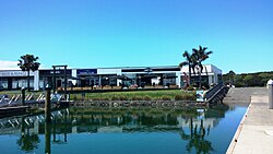 Marsden Cove shops | |
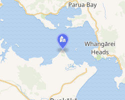 Interactive map of One Tree Point | |
| Coordinates: 35°49′08″S 174°27′14″E / 35.819°S 174.454°E / -35.819; 174.454 | |
| Country | New Zealand |
| Region | Northland Region |
| District | Whangarei District |
| Ward | Bream Bay Ward |
| Electorates | |
| Government | |
| • Territorial Authority | Whangarei District Council |
| • Regional council | Northland Regional Council |
| • Mayor of Whangārei | Ken Couper1 |
| • Whangārei MP | Shane Reti2 |
| • Te Tai Tokerau MP | Mariameno Kapa-Kingi3 |
| Area | |
• Total | 2.91 km2 (1.12 sq mi) |
| Population (June 2025)5 | |
• Total | 3,350 |
| • Density | 1,150/km2 (2,980/sq mi) |
One Tree Point is a settlement on the southern side of Whangārei Harbour in Northland, New Zealand. The settlement includes the Marsden Point Marina.6
History
One Tree Point was called "Single Tree Point" by Captain Lort Stokes of the Acheron in 1849.7
Demographics
Statistics New Zealand describes One Tree Point as a small urban area. It covers 2.91 km2 (1.12 sq mi)4 and had an estimated population of 3,350 as of June 2025,5 with a population density of 1,151 people per km2.
| Year | Pop. | ±% p.a. |
|---|---|---|
| 2006 | 912 | — |
| 2013 | 1,491 | +7.27% |
| 2018 | 2,217 | +8.26% |
| 2023 | 2,988 | +6.15% |
| The 2006 population is for a smaller area of 2.59 km2 Source: 89 | ||
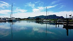
One Tree Point had a population of 2,988 in the 2023 New Zealand census, an increase of 771 people (34.8%) since the 2018 census, and an increase of 1,497 people (100.4%) since the 2013 census. There were 1,470 males, 1,509 females and 6 people of other genders in 1,188 dwellings.10 1.3% of people identified as LGBTIQ+. The median age was 49.9 years (compared with 38.1 years nationally). There were 555 people (18.6%) aged under 15 years, 282 (9.4%) aged 15 to 29, 1,245 (41.7%) aged 30 to 64, and 909 (30.4%) aged 65 or older.9
People could identify as more than one ethnicity. The results were 86.9% European (Pākehā); 19.5% Māori; 4.0% Pasifika; 5.2% Asian; 0.9% Middle Eastern, Latin American and African New Zealanders (MELAA); and 1.8% other, which includes people giving their ethnicity as "New Zealander". English was spoken by 97.6%, Māori language by 4.0%, Samoan by 0.4%, and other languages by 7.1%. No language could be spoken by 1.8% (e.g. too young to talk). New Zealand Sign Language was known by 0.4%. The percentage of people born overseas was 21.5, compared with 28.8% nationally.
Religious affiliations were 33.1% Christian, 0.6% Hindu, 0.1% Islam, 0.7% Māori religious beliefs, 0.3% Buddhist, 0.3% New Age, 0.1% Jewish, and 1.0% other religions. People who answered that they had no religion were 56.1%, and 7.6% of people did not answer the census question.
Of those at least 15 years old, 333 (13.7%) people had a bachelor's or higher degree, 1,353 (55.6%) had a post-high school certificate or diploma, and 627 (25.8%) people exclusively held high school qualifications. The median income was $37,800, compared with $41,500 nationally. 318 people (13.1%) earned over $100,000 compared to 12.1% nationally. The employment status of those at least 15 was that 1,035 (42.5%) people were employed full-time, 321 (13.2%) were part-time, and 27 (1.1%) were unemployed.9
Education
One Tree Point School is a coeducational contributing primary (years 1-6) school with a roll of 232 students as of March 2026.1112 The school was established in 1972.13
Notes
Notes
- "2025 local election final results". Whangarei District Council. Retrieved 17 October 2025.
- "Results — Whangārei (2023)". New Zealand Electoral Commission. Retrieved 27 February 2025.
- "Te Tai Tokerau – Official Result". Electoral Commission. Retrieved 27 February 2025.
- "ArcGIS Web Application". statsnz.maps.arcgis.com. Retrieved 27 April 2024.
- "Subnational population estimates - Aotearoa Data Explorer". Statistics New Zealand. Retrieved 29 October 2025.
- Harriss, Gavin (November 2021). "NZ Topo Map" (Map). One Tree Point, Northland.
- Parkes, W. F. (1992). Guide to Whangarei City and District. p. 15. ISBN 0-473-01639-7.
- "Statistical area 1 dataset for 2018 Census". Statistics New Zealand. March 2020. 7000921–7000934.
- "Totals by topic for individuals, (RC, TALB, UR, SA3, SA2, Ward, Health), 2013, 2018, and 2023 Censuses". Stats NZ – Tatauranga Aotearoa – Aotearoa Data Explorer. One Tree Point (1049). Retrieved 3 October 2024.
- "Totals by topic for dwellings, (RC, TALB, UR, SA3, SA2, Ward, Health), 2013, 2018, and 2023 Censuses". Stats NZ – Tatauranga Aotearoa – Aotearoa Data Explorer. Retrieved 3 October 2024.
- "New Zealand Schools Directory". New Zealand Ministry of Education. Retrieved 1 March 2026.
- "One Tree Point School - Education Counts". www.educationcounts.govt.nz.
- "General Information". One Tree Point School. Archived from the original on 14 October 2008. Retrieved 24 April 2008.