Ohinemutu | |
|---|---|
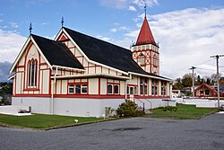 St Faith's Anglican Church | |
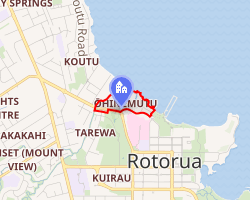 Interactive map of Ohinemutu | |
| Coordinates: 38°07′44″S 176°14′42″E / 38.129°S 176.245°E / -38.129; 176.245 | |
| Country | New Zealand |
| City | Rotorua |
| Local authority | Rotorua Lakes Council |
| Electoral ward | Te Ipu Wai Auraki General Ward |
| Area | |
| • Land | 121 ha (300 acres) |
| Population (June 2025)2 | |
• Total | 1,100 |
| • Density | 910/km2 (2,400/sq mi) |
| Koutu | Lake Rotorua | (Lake Rotorua) |
| Mangakakahi |
|
Lake Rotorua |
| Utuhina | Victoria | Rotorua Central |
Ohinemutu is a suburb in Rotorua, New Zealand. It includes a living Māori village and the original settlement of Rotorua. The organiser of a celebration for the area having been settled for 650 years said it has been continuously inhabited since 1365.3
Demographics
The statistical area of Kuirau, which corresponds to Ohinemutu, covers 1.21 km2 (0.47 sq mi)1 and had an estimated population of 1,100 as of June 2025,2 with a population density of 909 people per km2.
| Year | Pop. | ±% p.a. |
|---|---|---|
| 2006 | 927 | — |
| 2013 | 921 | −0.09% |
| 2018 | 1,065 | +2.95% |
| 2023 | 1,080 | +0.28% |
| Source: 45 | ||
Kuirau had a population of 1,080 in the 2023 New Zealand census, an increase of 15 people (1.4%) since the 2018 census, and an increase of 159 people (17.3%) since the 2013 census. There were 549 males, 528 females, and 3 people of other genders in 429 dwellings.6 2.5% of people identified as LGBTIQ+. The median age was 35.5 years (compared with 38.1 years nationally). There were 228 people (21.1%) aged under 15 years, 219 (20.3%) aged 15 to 29, 477 (44.2%) aged 30 to 64, and 156 (14.4%) aged 65 or older.4
People could identify as more than one ethnicity. The results were 35.0% European (Pākehā); 67.8% Māori; 9.4% Pasifika; 14.4% Asian; 0.3% Middle Eastern, Latin American and African New Zealanders (MELAA); and 0.6% other, which includes people giving their ethnicity as "New Zealander". English was spoken by 94.2%, Māori by 29.7%, and other languages by 11.4%. No language could be spoken by 2.5% (e.g. too young to talk). New Zealand Sign Language was known by 0.8%. The percentage of people born overseas was 18.3, compared with 28.8% nationally.4
Religious affiliations were 34.4% Christian, 3.3% Hindu, 0.3% Islam, 7.2% Māori religious beliefs, 0.8% Buddhist, 0.3% New Age, and 1.7% other religions. People who answered that they had no religion were 47.5%, and 5.6% of people did not answer the census question.4
Of those at least 15 years old, 168 (19.7%) people had a bachelor's or higher degree, 447 (52.5%) had a post-high school certificate or diploma, and 246 (28.9%) people exclusively held high school qualifications. The median income was $33,900, compared with $41,500 nationally. 45 people (5.3%) earned over $100,000 compared to 12.1% nationally. The employment status of those at least 15 was 396 (46.5%) full-time, 117 (13.7%) part-time, and 51 (6.0%) unemployed.4
Marae


The Ohinemutu area has four marae:
- Te Kuirau or Utuhina Marae and Te Roro o Te Rangi meeting house is a meeting place of the Ngāti Whakaue hapū of Ngāti te Roro o te Rangi.78
- Te Papaiouru Marae and Tamatekapua meeting house is a meeting place of the Ngāti Whakaue hapū of Ngāti Hurunga Te Rangi, Ngāti Pūkaki, Ngāti Taeotu, Ngāti Te Rangiwaho, Ngāti te Roro o te Rangi and Ngāti Tūnohopū.78
- Para te Hoata or Tūnohopū Marae and Tūnohopū meeting house is a meeting place of the Ngāti Whakaue hapū of Ngāti Tūnohopū and Ngāti Whakaue.78
- Waikite Marae and Tiki meeting house is a meeting place of the Ngāti Whakaue hapū of Ngāti Whakaue.78
Notable people
References
References
- "Stats NZ Geographic Data Service". Statistical Area 2 2023 (generalised). Retrieved 20 June 2025.
- "Subnational population estimates - Aotearoa Data Explorer". Statistics New Zealand. Retrieved 29 October 2025.
- "Ohinemutu marks nearly 650 years". Rotorua Daily Post. 15 November 2013.
- "Totals by topic for individuals, (RC, TALB, UR, SA3, SA2, Ward, Health), 2013, 2018, and 2023 Censuses". Stats NZ – Tatauranga Aotearoa – Aotearoa Data Explorer. Kuirau (199800). Retrieved 3 October 2024.
- "Statistical area 1 dataset for 2018 Census". Statistics New Zealand. March 2020. Kuirau (199800). 2018 Census place summary: Kuirau
- "Totals by topic for dwellings, (RC, TALB, UR, SA3, SA2, Ward, Health), 2013, 2018, and 2023 Censuses". Stats NZ – Tatauranga Aotearoa – Aotearoa Data Explorer. Retrieved 3 October 2024.
- "Te Kāhui Māngai directory". tkm.govt.nz. Te Puni Kōkiri.
- "Māori Maps". maorimaps.com. Te Potiki National Trust.