Nutter | |
|---|---|
Hamlet | |
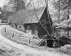 Hazelbekke watermill | |
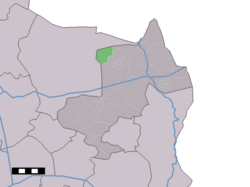 Nutter in the municipality of Dinkelland. | |
Nutter Location in the Netherlands Show map of OverijsselNutter Nutter (Netherlands) Show map of Netherlands | |
| Coordinates: 52°25′30″N 6°52′41″E / 52.42500°N 6.87806°E / 52.42500; 6.87806 | |
| Country | Netherlands |
| Province | Overijssel |
| Municipality | Dinkelland |
| Area | |
• Total | 5.35 km2 (2.07 sq mi) |
| Elevation | 65 m (213 ft) |
| Population (2021)1 | |
• Total | 190 |
| • Density | 36/km2 (92/sq mi) |
| Time zone | UTC+1 (CET) |
| • Summer (DST) | UTC+2 (CEST) |
| Postal code | 76381 |
| Dialing code | 0541 |
Nutter is a hamlet in the Dutch province of Overijssel. It is a part of the municipality of Dinkelland, and lies about 13 km north of Oldenzaal.
It was first mentioned in 1297 as Nuthere. The etymology is unclear.3 In 1840, it was home to 194 people. There are direction signs to Nutter, but no place name signs that you have arrived.4
Gallery
-
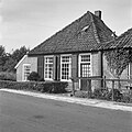 Cottage
 -
 Cottage
 -
 Barn
Barn
References
References
- "Kerncijfers wijken en buurten 2021". Central Bureau of Statistics. Retrieved 15 March 2022.
- "Postcodetool for 7638PA". Actueel Hoogtebestand Nederland (in Dutch). Het Waterschapshuis. Retrieved 15 March 2022.
- "Nutter - (geografische naam)". Etymologiebank (in Dutch). Retrieved 15 March 2022.
- "Nutter". Plaatsengids (in Dutch). Retrieved 15 March 2022.