Nelaug | |
|---|---|
Village | |
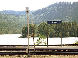 View from the railway station looking out on the lake | |
Nelaug Location of the village Show map of AgderNelaug Nelaug (Norway) Show map of Norway | |
| Coordinates: 58°39′23″N 8°38′00″E / 58.6565°N 08.6333°E / 58.6565; 08.6333 | |
| Country | Norway |
| Region | Southern Norway |
| County | Agder |
| District | Østre Agder |
| Municipality | Åmli |
| Elevation | 140 m (460 ft) |
| Time zone | UTC+01:00 (CET) |
| • Summer (DST) | UTC+02:00 (CEST) |
| Post Code | 4863 Nelaug |
Nelaug is a village in the southern part of the municipality of Åmli in Agder county, Norway. The population (2001) was 161.2 The village lies at east of the Nelaug lake, which is regulated by a hydroelectric power plant. The most notable feature in the village is the train station, Nelaug Station, which is the junction between the main Sørland Line and the branch Arendal Line. Nelaug school is a 1st through 6th grade elementary school. It is one of the three schools in Åmli municipality. Nelaug sits at the end of Norwegian County Road 412 which connects Nelaug to the Norwegian County Road 415 and the rest of Norway.
Name
The Old Norse form of the name must have been Niðlaug. The first element Nið is the old name of the river Nidelva and the last element is laug which means "lake".3
Climate
| Climate data for Nelaug 1991-2020 (142 m) | |||||||||||||
|---|---|---|---|---|---|---|---|---|---|---|---|---|---|
| Month | Jan | Feb | Mar | Apr | May | Jun | Jul | Aug | Sep | Oct | Nov | Dec | Year |
| Mean daily maximum °C (°F) | 1.5 (34.7) |
2.2 (36.0) |
5.6 (42.1) |
10.8 (51.4) |
16.3 (61.3) |
20 (68) |
22.2 (72.0) |
20.9 (69.6) |
16.1 (61.0) |
10.3 (50.5) |
5.4 (41.7) |
2.1 (35.8) |
11.1 (52.0) |
| Daily mean °C (°F) | −1.6 (29.1) |
−1.5 (29.3) |
1.2 (34.2) |
5.5 (41.9) |
10.6 (51.1) |
14.5 (58.1) |
16.7 (62.1) |
15.7 (60.3) |
11.7 (53.1) |
6.7 (44.1) |
2.6 (36.7) |
−0.9 (30.4) |
6.8 (44.2) |
| Mean daily minimum °C (°F) | −4.5 (23.9) |
−4.6 (23.7) |
−2.8 (27.0) |
0.8 (33.4) |
5.1 (41.2) |
9.3 (48.7) |
11.7 (53.1) |
11.2 (52.2) |
8.1 (46.6) |
3.7 (38.7) |
0.1 (32.2) |
−3.7 (25.3) |
2.9 (37.2) |
| Average precipitation mm (inches) | 148 (5.8) |
92 (3.6) |
83 (3.3) |
68 (2.7) |
83 (3.3) |
92 (3.6) |
95 (3.7) |
134 (5.3) |
136 (5.4) |
161 (6.3) |
164 (6.5) |
138 (5.4) |
1,394 (54.9) |
| Average precipitation days (≥ 1.0 mm) | 14 | 11 | 10 | 9 | 10 | 10 | 10 | 11 | 11 | 13 | 14 | 14 | 137 |
| Source 1: Yr.no Nelaug statistics4 | |||||||||||||
| Source 2: Noaa WMO averages 91-2020 Norway 5 | |||||||||||||
References
References
- "Nelaug, Åmli (Aust-Agder)". yr.no. Retrieved 20 December 2017.
- Statistisk sentralbyrå (2001). "Folke- og boligtellingen 2001, kommune- og bydelshefter 0929 Åmli" (PDF) (in Norwegian).
- Thorsnæs, Geir, ed. (15 July 2015). "Nelaug – innsjø". Store norske leksikon (in Norwegian). Kunnskapsforlaget. Retrieved 20 December 2017.
- "Weather statistics for Nelaug". Yr.no. Retrieved 4 February 2022.
- "NOAA WMO normals Norway 1991-2020".