Naitaba | |
| Geography | |
|---|---|
| Location | Fiji |
| Coordinates | 17°01′S 179°17′W / 17.017°S 179.283°W / -17.017; -179.283 |
| Archipelago | Lau Islands |
| Highest elevation | 186 m (610 ft) |
| Administration | |
Fiji | |
| Division | Eastern Division |
| Province | Lau Province |
| District | Lau Other Islands |
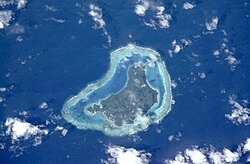
Naitaba Island (Naitauba,1 Naitaba2) 34 is an island of the northern Lau Islands of Fiji. It is a triangular shaped island approximately 2.4 km (1.5 mi) in diameter.5 The island is volcanic with coral and rises to 186 metres (610 ft) on a flat-topped hill toward the southern end of the island.6 The island is forested and coconuts were grown commercially for copra. There is a barrier reef completely surrounding the island.6
History
In early 1920 the coconut estates on Wakaya and Naitaba suffered a heavy loss due to a storm.7 In 1965 the actor Raymond Burr and his partner purchased 1,625 hectares (4,015 acres) on the island,8 where they raised copra and cattle.9 This land was sold in 1983 to Johannine Daist Communion for the use of Adi Da,10 with a purchase price of $2.1 million.11 It was reported that Adi Da died of cardiac arrest on November 27, 2008, at his home on the island, while working on his art.1213
References
References
- "Naitauba (Variant)" Naitaba at GEOnet Names Server, United States National Geospatial-Intelligence Agency
- "Naitaba (Variant) " Naitaba at GEOnet Names Server, United States National Geospatial-Intelligence Agency
- "Naitamba Island (Approved)" Naitaba at GEOnet Names Server, United States National Geospatial-Intelligence Agency
- Henderson, George Cockburn (1933) The Discoverers of the Fiji Islands: Tasman, Cook, Bligh, Wilson, Bellinghausen J. Murray, London, page 203, OCLC 56000674
- Bartholomew, John George (1890). The Royal Atlas & Gazetteer of Australasia. T. Nelson. p. 35. OCLC 25600847.
- "Damage at the islands". Taranaki Daily News. 10 March 1920. p. 5. Retrieved 25 July 2023.
- Mersmann, Andrew (April 2008). "Robert Benevides: Raymond Burr Vineyards, Sonoma County, California". Passport Online. Retrieved 21 May 2016.
- "History". Raymond Burr Vineyards. Archived from the original on 6 February 2012. Retrieved 21 May 2016.
- Duke, Lynne (12 June 2005). "Deep Throat's Daughter, The Kindred Free Spirit". The Washington Post. Retrieved 23 November 2010.
- Stanley, David (1992) Fiji Islands Handbook (3rd edition) Moon Publications, Chico, California, page 192, ISBN 0-918373-92-1
- "Spiritual leader passes on". www.fijitimes.com. November 28, 2008. Archived from the original on February 26, 2009. Retrieved February 20, 2010.
- "Lake County News | California - Followers mourn death of spiritual leader". Archived from the original on 27 June 2009. Retrieved 2 June 2010.