Muids | |
|---|---|
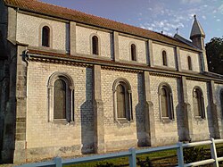 The church in Muids | |
 Coat of arms | |
 Location of Muids | |
Muids Muids | |
| Coordinates: 49°13′23″N 1°17′29″E / 49.2231°N 1.2914°E / 49.2231; 1.2914 | |
| Country | France |
| Region | Normandy |
| Department | Eure |
| Arrondissement | Les Andelys |
| Canton | Les Andelys |
| Intercommunality | Seine Normandie Agglomération |
| Government | |
| • Mayor (2020–2026) | Bernard Leboucq1 |
Area 1 | 15.22 km2 (5.88 sq mi) |
| Population (2023)2 | 861 |
| • Density | 56.6/km2 (147/sq mi) |
| Time zone | UTC+01:00 (CET) |
| • Summer (DST) | UTC+02:00 (CEST) |
| INSEE/Postal code | 27422 /27430 |
| Elevation | 7–76 m (23–249 ft) (avg. 25 m or 82 ft) |
| 1 French Land Register data, which excludes lakes, ponds, glaciers > 1 km2 (0.386 sq mi or 247 acres) and river estuaries. | |
Muids (French pronunciation: [mɥi]) is a commune in the Eure department in Normandy in northern France.
Population
| Year | Pop. | ±% |
|---|---|---|
| 1962 | 514 | — |
| 1968 | 546 | +6.2% |
| 1975 | 597 | +9.3% |
| 1982 | 733 | +22.8% |
| 1990 | 795 | +8.5% |
| 1999 | 828 | +4.2% |
| 2008 | 883 | +6.6% |
References
References
- "Répertoire national des élus: les maires". data.gouv.fr, Plateforme ouverte des données publiques françaises (in French). 2 December 2020.
- "Populations de référence 2023" (in French). National Institute of Statistics and Economic Studies. 18 December 2025.
Images


