| Mount Naeba | |
|---|---|
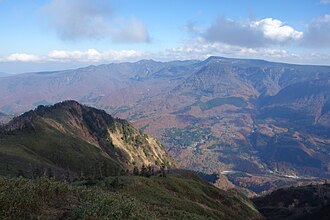 Naeba Volcano seen from the west | |
| Highest point | |
| Elevation | 2,145.3 m (7,038 ft) |
| Listing | List of mountains and hills of Japan by height |
| Coordinates | 36°50′45″N 138°41′25″E / 36.84583°N 138.69028°E / 36.84583; 138.69028 |
| Naming | |
| Native name | 苗場山 (Japanese) |
| Geography | |
| Parent range | Mikuni Mountains |
| Topo map(s) | Geographical Survey Institute 25000:1 苗場山, 50000:1 高田 |
| Geology | |
| Volcanic arc | Northeastern Japan Arc |
| Climbing | |
| Easiest route | Hike |
Mount Naeba (苗場山, Naeba-san) is a stratovolcano1 on the border of Nagano and Niigata prefectures in central Honshū, Japan. It is about 200 km (124 mi) from Tokyo. It was active between 200,000 and 800,000 years ago.1 It is primarily made of andesite.1 It is one of the 100 Famous Japanese Mountains.
-
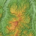 Relief map of Naeba Volcano.
 -
 Naeba Volcano seen from the east.
 -
 The wetland area of Mount Naeba.
References
References
- "NAEBA-SAN". Quaternary Volcanoes of Japan. Geological Survey of Japan, AIST. 2006. Retrieved 2008-12-21.
{{cite web}}: CS1 maint: deprecated archival service (link)
External links
External links
- Media related to Mount Naeba at Wikimedia Commons
- "Naeba". Global Volcanism Program. Smithsonian Institution. Retrieved 2021-06-24.
- Naeba San - Geological Survey of Japan