| Mount E | |
|---|---|
| 恵山 | |
 | |
| Highest point | |
| Elevation | 617.6 m (2,026 ft)1 |
| Listing | List of mountains and hills of Japan by height List of volcanoes in Japan |
| Coordinates | 41°48′17″N 141°09′58″E / 41.80472°N 141.16611°E / 41.80472; 141.166111 |
| Naming | |
Language of name | Japanese |
| Geography | |
Mount E Location of Mount E in Japan. Show map of HokkaidoMount E Mount E (Japan) Show map of Japan | |
| Location | Hokkaido, Japan |
| Parent range | Kameda Peninsula |
| Topo map(s) | Geospatial Information Authority 25000:1 恵山 50000:1 尻屋崎 |
| Geology | |
| Rock age | Pleistocene |
| Stratovolcano | |
| Volcanic arc | Northeastern Japan Arc |
| Last eruption | June 1874 |

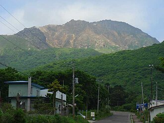
Mount E (恵山, E-san) is an active stratovolcano of the Kameda peninsula, which is itself part of the larger Oshima Peninsula. It is in the rural, eastern region of Hakodate, Hokkaido, Japan. Mount E is part of Esan Prefectural Natural Park.2
Geology
Mount E consists of non-alkali, mafic, volcanic rock.3 The andesitic volcano is topped with a lava dome.45
Eruptive history
Mount E last erupted on June 8, 1874. This eruption consisted of phreatic explosions, and was rated a 1 on the VEI scale.4
The oldest recorded eruption started November 18, 1846. The eruption triggered lahars damaging several houses and causing fatalities.45
Radiocarbon dating and tephrochronology indicate five other eruptions predating the historical records in the approximate years 1350, 550 BC, 1050 BC, 3900 BC ±100 years, 7050 BC. The eruption in 7050 BC was the largest with a VEI of 3.4
References
References
- Geospatial Information Authority topographic map 恵山
- 恵山道立自然公園 (in Japanese). HOKKAIDO Government. Retrieved 23 April 2010.
- "Hokkaido". Seamless digital geological map of Japan 1: 200,000. The Geological Survey of Japan, AIST. Feb 18, 2010. Archived from the original on 6 January 2013. Retrieved 25 April 2010.
- "Esan". Global Volcanism Program. Smithsonian Institution. Retrieved 2010-04-22.
- "E-SAN". Quaternary Volcanoes in Japan. Geological Survey of Japan, AIST. 2006. Retrieved 25 April 2010.
{{cite web}}: CS1 maint: deprecated archival service (link)
External links
External links
- Esan - Japan Meteorological Agency (in Japanese)
- "Esan: National catalogue of the active volcanoes in Japan" (PDF). - Japan Meteorological Agency
- Esan - Geological Survey of Japan
- Esan: Global Volcanism Program - Smithsonian Institution