Montbazon | |
|---|---|
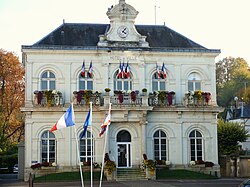 Town hall | |
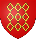 Coat of arms | |
 Location of Montbazon | |
Montbazon Montbazon | |
| Coordinates: 47°17′18″N 0°42′52″E / 47.2883°N 0.7144°E / 47.2883; 0.7144 | |
| Country | France |
| Region | Centre-Val de Loire |
| Department | Indre-et-Loire |
| Arrondissement | Tours |
| Canton | Monts |
| Government | |
| • Mayor (2020–2026) | Sylvie Giner1 |
Area 1 | 6.50 km2 (2.51 sq mi) |
| Population (2023)2 | 4,874 |
| • Density | 750/km2 (1,940/sq mi) |
| Time zone | UTC+01:00 (CET) |
| • Summer (DST) | UTC+02:00 (CEST) |
| INSEE/Postal code | 37154 /37250 |
| Elevation | 52–92 m (171–302 ft) |
| 1 French Land Register data, which excludes lakes, ponds, glaciers > 1 km2 (0.386 sq mi or 247 acres) and river estuaries. | |
Montbazon (French pronunciation: [mɔ̃bazɔ̃] ⓘ) is a commune in the Indre-et-Loire department, France. It is located on the river Indre between the towns of Veigné, Monts and Sorigny. The town is about 12 km from Tours.
History
In 991, friars of Cormery complained to the king that Fulk Nerra, lord of Anjou, was building a fortress in their land of Montbazon (he became lord of Montbazon in 997 although he was 17 years old).
From 994, the lofty fortress dominated a strategic point on the Indre river.
Population
Historical population | ||||||||||||||||||||||||||||||||||||||||||||||||||||||||||||||||||||||||||||||||||||||||||||||||||||||||||||||||||||||
|
| |||||||||||||||||||||||||||||||||||||||||||||||||||||||||||||||||||||||||||||||||||||||||||||||||||||||||||||||||||||
| Source: EHESS3 and INSEE (1968–2023)4 | ||||||||||||||||||||||||||||||||||||||||||||||||||||||||||||||||||||||||||||||||||||||||||||||||||||||||||||||||||||||
Economy
Montbazon has a small industrial park. It groups together small and medium-sized businesses.
Education
There are four schools in the town:
- Jean Le Bourg kindergarten
- Guillaume Louis Primary School
- Albert Camus High School
- Saint Gatien Private High School
Transportation
There are two bus lines (G and H) which cross the town. Four bus stops are located at:
- City Center
- Albert Camus High School
- La Courtille
- La Grange Barbier
There is also a TER rail line from Montbazon gare to Tours and intermediate stations.
Media
The town launched an online radio station in 2010.5
Sights

- Castle Site of Montbazon
- The fortress of Montbazon built by Fulk Nerra is one of the oldest fortress in France.
- Le Château d'Artigny
- Parcours botanique au fil de l'Indre
References
References
- "Répertoire national des élus: les maires". data.gouv.fr, Plateforme ouverte des données publiques françaises (in French). 2 December 2020.
- "Populations de référence 2023" (in French). National Institute of Statistics and Economic Studies. 18 December 2025.
- Des villages de Cassini aux communes d'aujourd'hui: Commune data sheet Montbazon, EHESS (in French).
- Population municipale entre 1968 et 2023, INSEE
- Radio Montbazon http://www.radiomontbazon.fr/ Archived 2010-06-22 at the Wayback Machine