Millers Point | |||||||||||||
|---|---|---|---|---|---|---|---|---|---|---|---|---|---|
 | |||||||||||||
Millers Point Location in metropolitan Sydney | |||||||||||||
 Interactive map of Millers Point | |||||||||||||
| Country | Australia | ||||||||||||
| State | New South Wales | ||||||||||||
| City | Sydney | ||||||||||||
| LGA | |||||||||||||
| Location |
| ||||||||||||
| Government | |||||||||||||
| • State electorate | |||||||||||||
| • Federal division | |||||||||||||
| Area | |||||||||||||
• Total | 0.25 km2 (0.097 sq mi) | ||||||||||||
| Population | |||||||||||||
| • Total | 1,735 (SAL 2021)2 | ||||||||||||
| • Density | 6,940/km2 (18,000/sq mi) | ||||||||||||
| Postcode | 2000 | ||||||||||||
| Parish | St. Philip | ||||||||||||
| |||||||||||||
Millers Point is an inner-city suburb of Sydney, in the state of New South Wales, Australia. It is on the north-western edge of the Sydney central business district, adjacent to The Rocks and is part of the local government area of the City of Sydney.
Millers Point lies on the southern shore of Sydney Harbour, beside Darling Harbour. The Barangaroo development is taking place on 22 hectares of land on the western side of the suburb.3 Millers Point historically includes what are now known as the suburbs of Dawes Point and Barangaroo and the renaming of those parts of Millers Point is controversial.4 The original headland of Millers Point is now known as Barangaroo Reserve, though the point itself has been returned to its original name.
History
On 30 June 1814 Thomas Miller, a Sergeant in the 73rd Regiment of Foot, received a grant of land from the governor.5 A small mill that was owned by an ex-convict,6 Jack Leighton was located here. The area became known as Jack, the Miller's Point.5 In 1833 Governor Bourke granted the Catholic Church land at Millers Point for the construction of a school house that could serve as a chapel on Sundays. The Colonial Architect, Ambrose Hallen in consultation with Bishop Ullathorne, designed the school building which was completed by May 1835. It was a one-story building constructed in sandstone with two rooms that could be opened into one. St Brigid's Church is one of the oldest existing places of Catholic worship in Australia. The school was closed in 1992 but the church continues to be used by the local community.789
From 1841 to 1921, Miller's Point was the location of a gasworks owned by the Australian Gaslight Company.
The current Sydney Observatory building on Observatory Hill was completed in 1858 by English astronomer and clergyman William Scott. Also on Observatory Hill is the old Fort Street School, converted from the old Military Hospital at Fort Phillip in the 1850s. Fort Street School incorporated the first government secondary school in Australia, and after the secondary school moved out in 1975, its building has housed the National Trust of Australia; the primary school remains nearby in a separate, heritage-listed building.
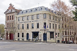
Two separate pubs in the area claim to be Sydney's oldest surviving pubs, the Lord Nelson (built in about 1836, but modified since6) at Millers Point and the Fortune of War (which was built in its current form in 1922, although a hotel was operating on the site in 183010) nearby at The Rocks. Other active pubs in the area include the Palisade, the Hero of Waterloo and the Captain Cook.
Population
At the 2021 census, the population of Millers Point was 1,735. 49.2% of people were born in Australia and 68.3% of people only spoke English at home. The most common response for religion was No Religion at 42.2%.11
In the 2016 census, there were 1,482 people in Millers Point. 42.5% of people were born in Australia and 59.9% of people only spoke English at home. The most common response for religion was No Religion at 29.3%.12
Protests

A protest movement developed from 2008 when various governments announced plans to lease and sell Millers Point, Dawes Point and The Rocks properties and move existing public housing tenants. "Save Our Community", "Friends of Millers Point" and the associated "Save Our Sirius" formed to protest the relocation of residents.13
Heritage listings

Millers Point has many heritage-listed sites, including:
- 1, 3, 5, 7 Argyle Place: 1–7 Argyle Place, Millers Point15
- 6, 8 Argyle Place: 6–8 Argyle Place, Millers Point16
- 9 Argyle Place: 9 Argyle Place, Millers Point17
- 10, 10a, 12, 12a Argyle Place: 10–12a Argyle Place, Millers Point18
- 22, 24, 26, 30, 32 Argyle Place: 22–32 Argyle Place, Millers Point19
- 34 Argyle Place: Osborne House20
- 36, 38 Argyle Place: 36–38 Argyle Place, Millers Point21
- 40, 42, 44 Argyle Place: 40–44 Argyle Place, Millers Point22
- 46, 48 Argyle Place: 46–48 Argyle Place, Millers Point23
- 50 Argyle Place: Undercliffe Cottage24
- 52, 54, 56, 58, 60 Argyle Place: Undercliffe Terrace25
- 62, 64 Argyle Place: 62–64 Argyle Place, Millers Point26
- Argyle Street: Garrison Anglican Church Precinct27
- 35–37 Bettington Street: Palisade Hotel28
- 56, 58, 60 Bettington Street: 56–60 Bettington Street, Millers Point29
- 66, 68 Bettington Street: 66–68 Bettington Street, Millers Point30
- 7, 9, 11, 13 Dalgety Road: 7–13 Dalgety Road, Millers Point31
- 15, 17, 19, 21, 23, 25 Dalgety Road: 15–25 Dalgety Road, Millers Point32
- 27a, 29a, 31a, 33, 35a Dalgety Road: 27a–35a Dalgety Road, Millers Point33
- Hickson Road: Grafton Bond Store34
- Hickson Road: Walsh Bay Wharves Precinct35
- 2–36 High Street: 2–36 High Street, Millers Point36
- 3, 5, 7, 9 High Street: 3–9 High Street, Millers Point37
- 38–72 High Street: 38–72 High Street, Millers Point38
- 74–80 High Street: 74–80 High Street, Millers Point39
- 2–4 Jenkins Street: MSB Stores Complex40
- 1–17 Kent Street: Oswald Bond Store41
- 12 Kent Street: Millers Point Post Office42
- 14, 16 Kent Street: St Brigid's Roman Catholic Church43
- 18, 20, 22 Kent Street: 18-22 Kent Street, Millers Point44
- 19 Kent Street: Lord Nelson Hotel6
- 21, 23, 25, 27, 29 Kent Street: 21–29 Kent Street, Millers Point45
- 24, 26 Kent Street: House of Bodleigh46
- 28 Kent Street: 28 Kent Street, Millers Point47
- 30 Kent Street: 30 Kent Street, Millers Point48
- 32, 34, 36, 38, 40 Kent Street: 32–40 Kent Street, Millers Point49
- 33, 35 Kent Street: Captain Cook Hotel50
- 37, 39, 41, 43, 45, 47 Kent Street: Alfred's Terrace51
- 42 Kent Street: 42 Kent Street, Millers Point52
- 44 Kent Street: 44 Kent Street, Millers Point53
- 46 Kent Street: 46 Kent Street, Millers Point54
- 48, 50 Kent Street: 48–50 Kent Street, Millers Point55
- 49, 51 Kent Street: 49–51 Kent Street, Millers Point56
- 52, 54 Kent Street: 52–54 Kent Street, Millers Point57
- 53, 55 Kent Street: 53–55 Kent Street, Millers Point58
- 56, 58 Kent Street: 56–58 Kent Street, Millers Point59
- 59, 61, 63 Kent Street: Hexam Terrace60
- 60, 62 Kent Street: 60–62 Kent Street, Millers Point61
- 71, 73 Kent Street: 71–73 Kent Street, Millers Point62
- 75, 77, 79 Kent Street: Winsbury Terrace63
- 81 Kent Street: Katoomba House64
- 82, 84, 86, 88 Kent Street: Blyth Terrace65
- 83, 85 Kent Street: 83–85 Kent Street, Millers Point66
- 90, 92 Kent Street: 90–92 Kent Street, Millers Point67
- 94 Kent Street: Toxteth68
- 115, 117, 119, 121 Kent Street: 115–121 Kent Street, Millers Point69
- 123, 125 Kent Street: 123–125 Kent Street, Millers Point70
- 1–19 Lower Fort Street: Milton Terrace71
- 18 Lower Fort Street: Harbour View Hotel72
- 20 Lower Fort Street: 20 Lower Fort Street, Millers Point73
- 21, 23 Lower Fort Street: 21–23 Lower Fort Street, Millers Point74
- 22 Lower Fort Street: 22 Lower Fort Street, Millers Point75
- 24, 26 Lower Fort Street: 24–26 Lower Fort Street, Millers Point76
- 25, 27, 29, 31, 33, 35 Lower Fort Street: Linsley Terrace77
- 28 Lower Fort Street: 28 Lower Fort Street, Millers Point78
- 30, 32, 34, 36, 38, 40, 42 Lower Fort Street: 30–42 Lower Fort Street, Millers Point79
- 39, 41 Lower Fort Street: 39–41 Lower Fort Street, Millers Point80
- 43 Lower Fort Street: Clydebank81
- 47, 49, 51, 53 Lower Fort Street: 47–53 Lower Fort Street, Millers Point82
- 55 Lower Fort Street: 55 Lower Fort Street, Millers Point83
- 57, 59, 61 Lower Fort Street: Regency Townhouses84
- 63, 65 Lower Fort Street: Vermont Terrace85
- 67, 69, 71, 73 Lower Fort Street: Eagleton Terrace8687
- 75, 77 Lower Fort Street: 75–77 Lower Fort Street, Millers Point88
- 79 Lower Fort Street: 79 Lower Fort Street, Millers Point89
- 81, 83 Lower Fort Street: Hero of Waterloo Hotel90
- 85 Lower Fort Street: Argyle House91
- 14–16 Merriman Street: 14–16 Merriman Street, Millers Point92
- 18 Merriman Street: 18 Merriman Street, Millers Point93
- 20, 22, 24, 26, 28, 30, 32, 34, 36, 38, 40, 42, 44, 48 Merriman Street: Merriman Street Terraces94
- Munn Street: Dalgety's Bond Stores95
- 18, 18a, 20, 20a Munn Street: 18–20a Munn Street, Millers Poin96
- Sydney Harbour Bridge (southern approaches/exits)9798
- Trinity Avenue: Argyle Street Railway Substation99
- 2, 4 Trinity Avenue: 2–4 Trinity Avenue, Millers Point100
- 8, 10, 12 Trinity Avenue: Darling House101
- 14, 16, 18, 20, 22 Trinity Avenue: 14–22 Trinity Avenue, Millers Point102
- Upper Fort Street: Millers Point & Dawes Point Village Precinct103
- Upper Fort Street: Sydney Observatory104
- 1–63 Windmill Street: 1–63 Windmill Street, Millers Point105
- 65 Windmill Street: 65 Windmill Street, Millers Point106
- 67 Windmill Street: 67 Windmill Street, Millers Point107
- 69 Windmill Street: 69 Windmill Street, Millers Point108
- 71 Windmill Street: 71 Windmill Street, Millers Point109
- 73 Windmill Street: Stevens Terrace110
- 75 Windmill Street: Shipwrights Arms Inn111
- 82–84 Windmill Street: 82–84 Windmill Street, Millers Point112113
- 86, 88 Windmill Street: 86–88 Windmill Street, Millers Point114
- 90–92 Windmill Street: 90–92 Windmill Street, Millers Point115116
In addition, the following Millers Point buildings are listed on various other heritage registers:117
- Agar Steps and houses
- Argyle Cut and Argyle Street Space
- 110–114A Kent Street: Carlson Terrace118
- 116–122 Kent Street: Richmond Villa119120
- 124–134 Kent Street: Glover cottages121122
- National Trust Centre (former Fort Street School), including S.H. Ervin Gallery
Gallery
-
 Garrison Church
 -
 Lord Nelson, one of Sydney's oldest pubs
 -
 The Hero of Waterloo pub
 -
 The Palisade Hotel
 -
 Federation Filigree homes, High Street
 -
 Former Fort Street School, now used by the National Trust
 -
 Carlson Terrace, Kent Street
 -
 37 Lower Fort St in 2014
 -
 Protest Signs in 2014
 -

-
 The historic Walsh Bay wharves
 -
 Roslyn Packer Theatre. 2026
See also
See also
- Barangaroo, New South Wales
- Sirius Building (with other public housing in Millers Point, threatened by sell-off during 2014)
References
References
- Australian Bureau of Statistics (28 June 2022). "Millers Point (suburb and locality)". Australian Census 2021 QuickStats. Retrieved 28 June 2022.
- Australian Bureau of Statistics (28 June 2022). "Millers Point (suburb and locality)". Australian Census 2021 QuickStats. Retrieved 28 June 2022.
- Barangaroo a north shore girl Archived 7 February 2012 at the Wayback Machine, City of Sydney, 19 October 2006. Retrieved 5 December 2006.
- "Millers Point | The Dictionary of Sydney". dictionaryofsydney.org. Retrieved 30 November 2025.
- Pollon, Frances, ed. (1990). The Book of Sydney Suburbs. Australia: Angus & Robertson Publishers. p. 189. ISBN 0-207-14495-8.
- "Lord Nelson Hotel". New South Wales State Heritage Register. Department of Planning & Environment. H00509. Retrieved 18 May 2018. Text is licensed by State of New South Wales (Department of Planning and Environment) under CC BY 4.0 licence.
- "Locate St Brigid's - St Patrick's Catholic Church - Church Hill - Sydney". Archived from the original on 8 May 2006. Retrieved 24 January 2006.
- Hosie, J. (1989). "Australia's oldest Catholic church". Journal of the Australian Catholic Historical Society (11): 44–56.
- http://www.deh.gov.au/cgi-bin/heritage/photodb/imagesearch.pl?proc=detail;barcode_no=rt46731
- "Fortune of War Hotel". New South Wales State Heritage Register. Department of Planning & Environment. H01547. Retrieved 6 November 2018. Text is licensed by State of New South Wales (Department of Planning and Environment) under CC BY 4.0 licence.
- "2021 Millers Point, Census All persons QuickStats". Australian Bureau of Statistics. Retrieved 20 August 2022.
- Australian Bureau of Statistics (27 June 2017). "Millers Point (State Suburb)". 2016 Census QuickStats. Retrieved 2 July 2016.
- "save our community". save-our-community. Retrieved 6 November 2014.
- "Millers Point Conservation Area". New South Wales State Heritage Register. Department of Planning & Environment. H00884. Retrieved 21 January 2020. Text is licensed by State of New South Wales (Department of Planning and Environment) under CC BY 4.0 licence.
- "Shops". New South Wales State Heritage Register. Department of Planning & Environment. H00863. Retrieved 18 May 2018. Text is licensed by State of New South Wales (Department of Planning and Environment) under CC BY 4.0 licence.
- "Shops". New South Wales State Heritage Register. Department of Planning & Environment. H00870. Retrieved 18 May 2018. Text is licensed by State of New South Wales (Department of Planning and Environment) under CC BY 4.0 licence.
- "Shop and Residence". New South Wales State Heritage Register. Department of Planning & Environment. H00865. Retrieved 18 May 2018. Text is licensed by State of New South Wales (Department of Planning and Environment) under CC BY 4.0 licence.
- "Shops". New South Wales State Heritage Register. Department of Planning & Environment. H00891. Retrieved 18 May 2018. Text is licensed by State of New South Wales (Department of Planning and Environment) under CC BY 4.0 licence.
- "Terrace". New South Wales State Heritage Register. Department of Planning & Environment. H00905. Retrieved 18 May 2018. Text is licensed by State of New South Wales (Department of Planning and Environment) under CC BY 4.0 licence.
- "Osborne House". New South Wales State Heritage Register. Department of Planning & Environment. H00886. Retrieved 18 May 2018. Text is licensed by State of New South Wales (Department of Planning and Environment) under CC BY 4.0 licence.
- "Houses". New South Wales State Heritage Register. Department of Planning & Environment. H00878. Retrieved 18 May 2018. Text is licensed by State of New South Wales (Department of Planning and Environment) under CC BY 4.0 licence.
- "Terraces". New South Wales State Heritage Register. Department of Planning & Environment. H00926. Retrieved 18 May 2018. Text is licensed by State of New South Wales (Department of Planning and Environment) under CC BY 4.0 licence.
- "Terraces". New South Wales State Heritage Register. Department of Planning & Environment. H00924. Retrieved 18 May 2018. Text is licensed by State of New South Wales (Department of Planning and Environment) under CC BY 4.0 licence.
- "Undercliffe Cottage (former)". New South Wales State Heritage Register. Department of Planning & Environment. H00929. Retrieved 18 May 2018. Text is licensed by State of New South Wales (Department of Planning and Environment) under CC BY 4.0 licence.
- "Undercliffe Terrace". New South Wales State Heritage Register. Department of Planning & Environment. H00902. Retrieved 18 May 2018. Text is licensed by State of New South Wales (Department of Planning and Environment) under CC BY 4.0 licence.
- "Terrace". New South Wales State Heritage Register. Department of Planning & Environment. H00895. Retrieved 18 May 2018. Text is licensed by State of New South Wales (Department of Planning and Environment) under CC BY 4.0 licence.
- "Garrison Anglican Church Precinct". New South Wales State Heritage Register. Department of Planning & Environment. H00644. Retrieved 18 May 2018. Text is licensed by State of New South Wales (Department of Planning and Environment) under CC BY 4.0 licence.
- "Palisade Hotel". New South Wales State Heritage Register. Department of Planning & Environment. H00510. Retrieved 18 May 2018. Text is licensed by State of New South Wales (Department of Planning and Environment) under CC BY 4.0 licence.
- "Victorian Terrace". New South Wales State Heritage Register. Department of Planning & Environment. H00922. Retrieved 18 May 2018. Text is licensed by State of New South Wales (Department of Planning and Environment) under CC BY 4.0 licence.
- "Edwardian Terrace". New South Wales State Heritage Register. Department of Planning & Environment. H00848. Retrieved 18 May 2018. Text is licensed by State of New South Wales (Department of Planning and Environment) under CC BY 4.0 licence.
- "Dalgety Terrace". New South Wales State Heritage Register. Department of Planning & Environment. H00867. Retrieved 18 May 2018. Text is licensed by State of New South Wales (Department of Planning and Environment) under CC BY 4.0 licence.
- "Terraces". New South Wales State Heritage Register. Department of Planning & Environment. H00925. Retrieved 18 May 2018. Text is licensed by State of New South Wales (Department of Planning and Environment) under CC BY 4.0 licence.
- "Terraces". New South Wales State Heritage Register. Department of Planning & Environment. H00923. Retrieved 18 May 2018. Text is licensed by State of New South Wales (Department of Planning and Environment) under CC BY 4.0 licence.
- "Grafton Bond Store and Sandstone Wall". New South Wales State Heritage Register. Department of Planning & Environment. H01431. Retrieved 18 May 2018. Text is licensed by State of New South Wales (Department of Planning and Environment) under CC BY 4.0 licence.
- "Walsh Bay Wharves Precinct". New South Wales State Heritage Register. Department of Planning & Environment. H00559. Retrieved 18 May 2018. Text is licensed by State of New South Wales (Department of Planning and Environment) under CC BY 4.0 licence.
- "Terrace Duplexes". New South Wales State Heritage Register. Department of Planning & Environment. H00920. Retrieved 18 May 2018. Text is licensed by State of New South Wales (Department of Planning and Environment) under CC BY 4.0 licence.
- "Terrace Duplexes". New South Wales State Heritage Register. Department of Planning & Environment. H00918. Retrieved 18 May 2018. Text is licensed by State of New South Wales (Department of Planning and Environment) under CC BY 4.0 licence.
- "Terrace Duplexes". New South Wales State Heritage Register. Department of Planning & Environment. H00919. Retrieved 18 May 2018. Text is licensed by State of New South Wales (Department of Planning and Environment) under CC BY 4.0 licence.
- "Terrace Duplexes". New South Wales State Heritage Register. Department of Planning & Environment. H00868. Retrieved 18 May 2018. Text is licensed by State of New South Wales (Department of Planning and Environment) under CC BY 4.0 licence.
- "MSB Stores Complex". New South Wales State Heritage Register. Department of Planning & Environment. H01435. Retrieved 18 May 2018. Text is licensed by State of New South Wales (Department of Planning and Environment) under CC BY 4.0 licence.
- "Oswald Bond Store". New South Wales State Heritage Register. Department of Planning & Environment. H00527. Retrieved 18 May 2018. Text is licensed by State of New South Wales (Department of Planning and Environment) under CC BY 4.0 licence.
- "Millers Point Post Office". New South Wales State Heritage Register. Department of Planning & Environment. H01408. Retrieved 18 May 2018. Text is licensed by State of New South Wales (Department of Planning and Environment) under CC BY 4.0 licence.
- "St. Brigid's Roman Catholic Church & School". New South Wales State Heritage Register. Department of Planning & Environment. H00645. Retrieved 18 May 2018. Text is licensed by State of New South Wales (Department of Planning and Environment) under CC BY 4.0 licence.
- "Terrace". New South Wales State Heritage Register. Department of Planning & Environment. H00917. Retrieved 18 May 2018. Text is licensed by State of New South Wales (Department of Planning and Environment) under CC BY 4.0 licence.
- "Edwardian Shop/Residences". New South Wales State Heritage Register. Department of Planning & Environment. H00888. Retrieved 18 May 2018. Text is licensed by State of New South Wales (Department of Planning and Environment) under CC BY 4.0 licence.
- "House of Bodleigh". New South Wales State Heritage Register. Department of Planning & Environment. H00873. Retrieved 18 May 2018. Text is licensed by State of New South Wales (Department of Planning and Environment) under CC BY 4.0 licence.
- "Building". New South Wales State Heritage Register. Department of Planning & Environment. H00854. Retrieved 18 May 2018. Text is licensed by State of New South Wales (Department of Planning and Environment) under CC BY 4.0 licence.
- "Building". New South Wales State Heritage Register. Department of Planning & Environment. H00855. Retrieved 18 May 2018. Text is licensed by State of New South Wales (Department of Planning and Environment) under CC BY 4.0 licence.
- "Terrace". New South Wales State Heritage Register. Department of Planning & Environment. H00864. Retrieved 18 May 2018. Text is licensed by State of New South Wales (Department of Planning and Environment) under CC BY 4.0 licence.
- "Captain Cook Hotel". New South Wales State Heritage Register. Department of Planning & Environment. H00511. Retrieved 18 May 2018. Text is licensed by State of New South Wales (Department of Planning and Environment) under CC BY 4.0 licence.
- "Alfred's Terrace". New South Wales State Heritage Register. Department of Planning & Environment. H00837. Retrieved 18 May 2018. Text is licensed by State of New South Wales (Department of Planning and Environment) under CC BY 4.0 licence.
- "Terrace". New South Wales State Heritage Register. Department of Planning & Environment. H00856. Retrieved 18 May 2018. Text is licensed by State of New South Wales (Department of Planning and Environment) under CC BY 4.0 licence.
- "Terrace". New South Wales State Heritage Register. Department of Planning & Environment. H00859. Retrieved 18 May 2018. Text is licensed by State of New South Wales (Department of Planning and Environment) under CC BY 4.0 licence.
- "Terrace". New South Wales State Heritage Register. Department of Planning & Environment. H00858. Retrieved 18 May 2018. Text is licensed by State of New South Wales (Department of Planning and Environment) under CC BY 4.0 licence.
- "Terrace House". New South Wales State Heritage Register. Department of Planning & Environment. H00921. Retrieved 18 May 2018. Text is licensed by State of New South Wales (Department of Planning and Environment) under CC BY 4.0 licence.
- "Stone House". New South Wales State Heritage Register. Department of Planning & Environment. H00876. Retrieved 18 May 2018. Text is licensed by State of New South Wales (Department of Planning and Environment) under CC BY 4.0 licence.
- "Terrace". New South Wales State Heritage Register. Department of Planning & Environment. H00871. Retrieved 18 May 2018. Text is licensed by State of New South Wales (Department of Planning and Environment) under CC BY 4.0 licence.
- "Stone House". New South Wales State Heritage Register. Department of Planning & Environment. H00900. Retrieved 18 May 2018. Text is licensed by State of New South Wales (Department of Planning and Environment) under CC BY 4.0 licence.
- "Terrace". New South Wales State Heritage Register. Department of Planning & Environment. H00841. Retrieved 18 May 2018. Text is licensed by State of New South Wales (Department of Planning and Environment) under CC BY 4.0 licence.
- "Hexam Terrace". New South Wales State Heritage Register. Department of Planning & Environment. H00872. Retrieved 18 May 2018. Text is licensed by State of New South Wales (Department of Planning and Environment) under CC BY 4.0 licence.
- "Terraces". New South Wales State Heritage Register. Department of Planning & Environment. H00909. Retrieved 18 May 2018. Text is licensed by State of New South Wales (Department of Planning and Environment) under CC BY 4.0 licence.
- "Terrace". New South Wales State Heritage Register. Department of Planning & Environment. H00914. Retrieved 18 May 2018. Text is licensed by State of New South Wales (Department of Planning and Environment) under CC BY 4.0 licence.
- "Winsbury Terrace". New South Wales State Heritage Register. Department of Planning & Environment. H00930. Retrieved 18 May 2018. Text is licensed by State of New South Wales (Department of Planning and Environment) under CC BY 4.0 licence.
- "Katoomba House". New South Wales State Heritage Register. Department of Planning & Environment. H00890. Retrieved 18 May 2018. Text is licensed by State of New South Wales (Department of Planning and Environment) under CC BY 4.0 licence.
- "Blyth Terrace". New South Wales State Heritage Register. Department of Planning & Environment. H00839. Retrieved 18 May 2018. Text is licensed by State of New South Wales (Department of Planning and Environment) under CC BY 4.0 licence.
- "Terrace". New South Wales State Heritage Register. Department of Planning & Environment. H00879. Retrieved 18 May 2018. Text is licensed by State of New South Wales (Department of Planning and Environment) under CC BY 4.0 licence.
- "Terrace". New South Wales State Heritage Register. Department of Planning & Environment. H00916. Retrieved 18 May 2018. Text is licensed by State of New South Wales (Department of Planning and Environment) under CC BY 4.0 licence.
- "Toxteth". New South Wales State Heritage Register. Department of Planning & Environment. H00928. Retrieved 18 May 2018. Text is licensed by State of New South Wales (Department of Planning and Environment) under CC BY 4.0 licence.
- "Terrace". New South Wales State Heritage Register. Department of Planning & Environment. H00908. Retrieved 18 May 2018. Text is licensed by State of New South Wales (Department of Planning and Environment) under CC BY 4.0 licence.
- "Terrace". New South Wales State Heritage Register. Department of Planning & Environment. H00901. Retrieved 18 May 2018. Text is licensed by State of New South Wales (Department of Planning and Environment) under CC BY 4.0 licence.
- "Milton Terrace". New South Wales State Heritage Register. Department of Planning & Environment. H00885. Retrieved 18 May 2018. Text is licensed by State of New South Wales (Department of Planning and Environment) under CC BY 4.0 licence.
- "Harbour View Hotel and site". New South Wales State Heritage Register. Department of Planning & Environment. H00634. Retrieved 18 May 2018. Text is licensed by State of New South Wales (Department of Planning and Environment) under CC BY 4.0 licence.
- "Townhouse". New South Wales State Heritage Register. Department of Planning & Environment. H00861. Retrieved 18 May 2018. Text is licensed by State of New South Wales (Department of Planning and Environment) under CC BY 4.0 licence.
- "Terrace". New South Wales State Heritage Register. Department of Planning & Environment. H00883. Retrieved 18 May 2018. Text is licensed by State of New South Wales (Department of Planning and Environment) under CC BY 4.0 licence.
- "Townhouse". New South Wales State Heritage Register. Department of Planning & Environment. H00880. Retrieved 18 May 2018. Text is licensed by State of New South Wales (Department of Planning and Environment) under CC BY 4.0 licence.
- "Building". New South Wales State Heritage Register. Department of Planning & Environment. H00852. Retrieved 18 May 2018. Text is licensed by State of New South Wales (Department of Planning and Environment) under CC BY 4.0 licence.
- "Linsley Terrace". New South Wales State Heritage Register. Department of Planning & Environment. H00907. Retrieved 18 May 2018. Text is licensed by State of New South Wales (Department of Planning and Environment) under CC BY 4.0 licence.
- "Townhouse". New South Wales State Heritage Register. Department of Planning & Environment. H00881. Retrieved 18 May 2018. Text is licensed by State of New South Wales (Department of Planning and Environment) under CC BY 4.0 licence.
- "Residence". New South Wales State Heritage Register. Department of Planning & Environment. H00894. Retrieved 18 May 2018. Text is licensed by State of New South Wales (Department of Planning and Environment) under CC BY 4.0 licence.
- "Georgian Townhouse". New South Wales State Heritage Register. Department of Planning & Environment. H00523. Retrieved 18 May 2018. Text is licensed by State of New South Wales (Department of Planning and Environment) under CC BY 4.0 licence.
- "Clydebank". New South Wales State Heritage Register. Department of Planning & Environment. H00524. Retrieved 18 May 2018. Text is licensed by State of New South Wales (Department of Planning and Environment) under CC BY 4.0 licence.
- "Terrace". New South Wales State Heritage Register. Department of Planning & Environment. H00906. Retrieved 18 May 2018. Text is licensed by State of New South Wales (Department of Planning and Environment) under CC BY 4.0 licence.
- "Building". New South Wales State Heritage Register. Department of Planning & Environment. H00525. Retrieved 18 May 2018. Text is licensed by State of New South Wales (Department of Planning and Environment) under CC BY 4.0 licence.
- "Regency Townhouses". New South Wales State Heritage Register. Department of Planning & Environment. H00887. Retrieved 18 May 2018. Text is licensed by State of New South Wales (Department of Planning and Environment) under CC BY 4.0 licence.
- "Vermont Terrace". New South Wales State Heritage Register. Department of Planning & Environment. H00910. Retrieved 18 May 2018. Text is licensed by State of New South Wales (Department of Planning and Environment) under CC BY 4.0 licence.
- "Eagleton Terrace". New South Wales State Heritage Register. Department of Planning & Environment. H00882. Retrieved 18 May 2018. Text is licensed by State of New South Wales (Department of Planning and Environment) under CC BY 4.0 licence.
- "Eagleton Terrace". New South Wales State Heritage Register. Department of Planning & Environment. H00904. Retrieved 18 May 2018. Text is licensed by State of New South Wales (Department of Planning and Environment) under CC BY 4.0 licence.
- "Building". New South Wales State Heritage Register. Department of Planning & Environment. H00844. Retrieved 18 May 2018. Text is licensed by State of New South Wales (Department of Planning and Environment) under CC BY 4.0 licence.
- "Shop & Residence". New South Wales State Heritage Register. Department of Planning & Environment. H00893. Retrieved 18 May 2018. Text is licensed by State of New South Wales (Department of Planning and Environment) under CC BY 4.0 licence.
- "Hero of Waterloo Hotel". New South Wales State Heritage Register. Department of Planning & Environment. H00633. Retrieved 18 May 2018. Text is licensed by State of New South Wales (Department of Planning and Environment) under CC BY 4.0 licence.
- "Argyle House". New South Wales State Heritage Register. Department of Planning & Environment. H00838. Retrieved 18 May 2018. Text is licensed by State of New South Wales (Department of Planning and Environment) under CC BY 4.0 licence.
- "Stone Cottage & Wall". New South Wales State Heritage Register. Department of Planning & Environment. H00840. Retrieved 18 May 2018. Text is licensed by State of New South Wales (Department of Planning and Environment) under CC BY 4.0 licence.
- "Cottage". New South Wales State Heritage Register. Department of Planning & Environment. H00857. Retrieved 18 May 2018. Text is licensed by State of New South Wales (Department of Planning and Environment) under CC BY 4.0 licence.
- "Merriman Street Terraces". New South Wales State Heritage Register. Department of Planning & Environment. H00903. Retrieved 18 May 2018. Text is licensed by State of New South Wales (Department of Planning and Environment) under CC BY 4.0 licence.
- "Warehouses". New South Wales State Heritage Register. Department of Planning & Environment. H00526. Retrieved 18 May 2018. Text is licensed by State of New South Wales (Department of Planning and Environment) under CC BY 4.0 licence.
- "Terrace". New South Wales State Heritage Register. Department of Planning & Environment. H00912. Retrieved 18 May 2018. Text is licensed by State of New South Wales (Department of Planning and Environment) under CC BY 4.0 licence.
- "Sydney Harbour Bridge, Bradfield Hwy, Dawes Point - Milsons Point, NSW, Australia (Place ID 105888)". Australian Heritage Database. Australian Government. Retrieved 28 October 2018.
- "Sydney Harbour Bridge, approaches and viaducts (road and rail)". New South Wales State Heritage Register. Department of Planning & Environment. H00781. Retrieved 13 October 2018. Text is licensed by State of New South Wales (Department of Planning and Environment) under CC BY 4.0 licence.
- "Argyle Street Railway Substation". New South Wales State Heritage Register. Department of Planning & Environment. H01022. Retrieved 18 May 2018. Text is licensed by State of New South Wales (Department of Planning and Environment) under CC BY 4.0 licence.
- "Flats". New South Wales State Heritage Register. Department of Planning & Environment. H00869. Retrieved 18 May 2018. Text is licensed by State of New South Wales (Department of Planning and Environment) under CC BY 4.0 licence.
- "Building". New South Wales State Heritage Register. Department of Planning & Environment. H00842. Retrieved 18 May 2018. Text is licensed by State of New South Wales (Department of Planning and Environment) under CC BY 4.0 licence.
- "Terrace". New South Wales State Heritage Register. Department of Planning & Environment. H00911. Retrieved 18 May 2018. Text is licensed by State of New South Wales (Department of Planning and Environment) under CC BY 4.0 licence.
- "Millers Point & Dawes Point Village Precinct". New South Wales State Heritage Register. Department of Planning & Environment. H01682. Retrieved 18 May 2018. Text is licensed by State of New South Wales (Department of Planning and Environment) under CC BY 4.0 licence.
- "Sydney Observatory". New South Wales State Heritage Register. Department of Planning & Environment. H01449. Retrieved 18 May 2018. Text is licensed by State of New South Wales (Department of Planning and Environment) under CC BY 4.0 licence.
- "Terrace". New South Wales State Heritage Register. Department of Planning & Environment. H00896. Retrieved 18 May 2018. Text is licensed by State of New South Wales (Department of Planning and Environment) under CC BY 4.0 licence.
- "Terrace". New South Wales State Heritage Register. Department of Planning & Environment. H00846. Retrieved 18 May 2018. Text is licensed by State of New South Wales (Department of Planning and Environment) under CC BY 4.0 licence.
- "Stone Shop". New South Wales State Heritage Register. Department of Planning & Environment. H00860. Retrieved 18 May 2018. Text is licensed by State of New South Wales (Department of Planning and Environment) under CC BY 4.0 licence.
- "Terrace". New South Wales State Heritage Register. Department of Planning & Environment. H00853. Retrieved 18 May 2018. Text is licensed by State of New South Wales (Department of Planning and Environment) under CC BY 4.0 licence.
- "Terrace". New South Wales State Heritage Register. Department of Planning & Environment. H00845. Retrieved 18 May 2018. Text is licensed by State of New South Wales (Department of Planning and Environment) under CC BY 4.0 licence.
- "Stevens Terrace". New South Wales State Heritage Register. Department of Planning & Environment. H00862. Retrieved 18 May 2018. Text is licensed by State of New South Wales (Department of Planning and Environment) under CC BY 4.0 licence.
- "Shipwrights Arms Inn (former)". New South Wales State Heritage Register. Department of Planning & Environment. H00850. Retrieved 18 May 2018. Text is licensed by State of New South Wales (Department of Planning and Environment) under CC BY 4.0 licence.
- "Royal College of Pathologists (former)". New South Wales State Heritage Register. Department of Planning & Environment. H00843. Retrieved 18 May 2018. Text is licensed by State of New South Wales (Department of Planning and Environment) under CC BY 4.0 licence.
- "Royal College of Pathologists (former)". New South Wales State Heritage Register. Department of Planning & Environment. H00851. Retrieved 18 May 2018. Text is licensed by State of New South Wales (Department of Planning and Environment) under CC BY 4.0 licence.
- "Terrace". New South Wales State Heritage Register. Department of Planning & Environment. H00897. Retrieved 18 May 2018. Text is licensed by State of New South Wales (Department of Planning and Environment) under CC BY 4.0 licence.
- "Building". New South Wales State Heritage Register. Department of Planning & Environment. H00847. Retrieved 18 May 2018. Text is licensed by State of New South Wales (Department of Planning and Environment) under CC BY 4.0 licence.
- "Building". New South Wales State Heritage Register. Department of Planning & Environment. H00849. Retrieved 18 May 2018. Text is licensed by State of New South Wales (Department of Planning and Environment) under CC BY 4.0 licence.
- The Heritage of Australia, Macmillan Company, 1981, pp. 2, 69–72
- "Terrace Group "Carlson Terrace" Including Interiors". New South Wales Heritage Database. Office of Environment & Heritage. Retrieved 26 September 2018.
- "House "Richmond Villa" Including Interior". New South Wales Heritage Database. Office of Environment & Heritage. Retrieved 29 November 2017.
- "Richmond Villa, 116-122 Kent St, Millers Point, NSW, Australia (Place ID 2347)". Australian Heritage Database. Australian Government. 21 March 1978. Retrieved 29 November 2017.
- "Terrace Group "Glover Cottages" Including Interiors". New South Wales Heritage Database. Office of Environment & Heritage. Retrieved 30 November 2017.
- "Glover Cottages, 124-126 Kent St, Millers Point, NSW, Australia (Place ID 2164)". Australian Heritage Database. Australian Government. 21 March 1978. Retrieved 30 November 2017.
Further reading
Further reading
- Brodsky, Isadore. Heart of the Rocks. Old Sydney Free Press, Australia. 1965.
- Fitzgerald, Shirley; Keating, Christopher. Millers Point, The Urban Village. Hale & Iremonger, Australia,1991. (ISBN 086806443 2)
- Karskens, Grace. Inside The Rocks. Published by Hale & Iremonger, Australia. 1999. (ISBN 0 86806 666 4)
External links
External links
- Fitzgerald, Shirley; City of Sydney Historian (2008). "Millers Point". Dictionary of Sydney. Retrieved 28 September 2015. [CC-By-SA]
- McCormack, Terri (2010). "Hero of Waterloo hotel". Dictionary of Sydney. Dictionary of Sydney Trust. Retrieved 10 October 2015.[CC-By-SA]
- Dunn, Mark (2008). "St Brigid's Catholic church Millers Point". Dictionary of Sydney. Dictionary of Sydney Trust. Retrieved 3 June 2016.[CC-By-SA]
- "Millers Point Community".