Miary | |
|---|---|
 Fiherenana River at Miary | |
Miary Location in Madagascar | |
| Coordinates: 23°18′S 43°44′E / 23.300°S 43.733°E / -23.300; 43.733 | |
| Country |  Madagascar Madagascar |
| Region | Atsimo-Andrefana |
| District | Toliara II |
| Area | |
• Total | 140 km2 (54 sq mi) |
| Elevation | 34 m (112 ft) |
| Population (2008)3 | |
• Total | 12,500 |
| • Ethnicities | Masikoro (90%) |
| Time zone | UTC3 (EAT) |
| Postal code | 602 |
Miary is a rural municipality in Madagascar. It belongs to the district of Toliara II, which is a part of Atsimo-Andrefana Region. The population of the municipality was estimated to be approximately 12500 in 20083 of which 90% are Masikoro. The municipality has 11 fokontany (villages).
Primary and junior level secondary education are available in town. The rate of scolarization in Miary had been 70% in 2007.4 Farming and raising livestock provides employment for 40% and 40% of the working population. The most important crops are cotton and cassava, while other important agricultural products are sugarcane and maize. Services provide employment for 20% of the population.3
Miary has a health center Type II (CSB II).
Geography
Miary lies on the left banks of the lower Fiherenana River, 10 km North-East of Tulear.
Sights
Miary is famous its sacred tree (L'arbre de Miary), a banyan which is said to be 1,700 years old.5 It is in the eastern part of the village close to the Market Place. On the Market Place opposite the Town hall (Mairie), a market hall and an independence memorial can be visited.
-
 L'arbre de Miary
 -
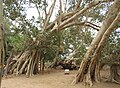 L'arbre de miary
 -
 Town hall
 -
 Market Place
 -
 Market hall
References
References
- LES STRATEGIES PAYSANNES DE DEVELOPPEMENT LES STRATEGIES PAYSANNES DE DEVELOPPEMENT DANS LA COMMUNE RURALE DE MIARY
- Estimated based on DEM data from Shuttle Radar Topography Mission
- "ILO census data". Cornell University. 2002. Retrieved 2008-03-13.
- Analyse écogéographique de la végétation sectorielle du Fiherenana - Nourddine MIRHANI, 2007. Université de Toliara
- Heiko Hooge: Madagaskar, p. 110. Ostfildern 2023
23°18′S 43°44′E / 23.300°S 43.733°E / -23.300; 43.733