| Marham | |
|---|---|
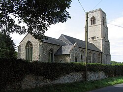 Holy Trinity church, Marham | |
Marham Location within Norfolk | |
| Area | 14.85 km2 (5.73 sq mi) |
| Population | 3,531 (2011) |
| • Density | 238/km2 (620/sq mi) |
| OS grid reference | TF 709 100 |
| Civil parish |
|
| District | |
| Shire county | |
| Region | |
| Country | England |
| Sovereign state | United Kingdom |
| Post town | KING'S LYNN |
| Postcode district | PE33 |
| Police | Norfolk |
| Fire | Norfolk |
| Ambulance | East of England |
Marham is a village and civil parish in the English county of Norfolk, approximate 12 miles (19 km) away from King's Lynn. An RAF station, RAF Marham, is situated nearby at Upper Marham.1 The village covers an area of 1,485 ha (3,670 acres) and had a population of 2,951 in 788 households as of the 2001 census,2 increasing to 3,531 at the 2011 Census.3
The villages name means 'Pool homestead/village' or 'hemmed-in land with a pool'.
Governance
Marham is a parish of the Kings Lynn and West Norfolk district council, which is responsible for the most local services. Norfolk County Council is in charge of roads, some schools, and social services, and the county councillor for the Gayton & Nar Valley division is Graham Middleton (Conservative) since 2017. For Westminster elections Marham forms part of the South West Norfolk constituency.
Religion
Holy Trinity Church of England parish church is a Grade I listed building.4 It dates from Norman times and has a Norman doorway. Since its original design, each part of the building has been reconstructed. The doorway has a single-scallop shaft on each side. The semi-circular arch is high enough to allow the tympanum within to be filled with a checkered "lozenge" pattern.5
Marham Methodist church joins with the Anglicans for some of its services.6
Climate
| Climate data for RAF Marham,a (1991–2020 normals, extremes 1957–present) | |||||||||||||
|---|---|---|---|---|---|---|---|---|---|---|---|---|---|
| Month | Jan | Feb | Mar | Apr | May | Jun | Jul | Aug | Sep | Oct | Nov | Dec | Year |
| Record high °C (°F) | 14.8 (58.6) |
18.9 (66.0) |
22.0 (71.6) |
27.2 (81.0) |
33.0 (91.4) |
33.9 (93.0) |
39.2 (102.6) |
34.8 (94.6) |
31.1 (88.0) |
28.9 (84.0) |
17.8 (64.0) |
16.0 (60.8) |
39.2 (102.6) |
| Mean daily maximum °C (°F) | 7.2 (45.0) |
8.0 (46.4) |
10.7 (51.3) |
13.9 (57.0) |
17.1 (62.8) |
19.9 (67.8) |
22.5 (72.5) |
22.3 (72.1) |
19.2 (66.6) |
14.9 (58.8) |
10.4 (50.7) |
7.5 (45.5) |
14.5 (58.1) |
| Daily mean °C (°F) | 4.2 (39.6) |
4.6 (40.3) |
6.7 (44.1) |
9.2 (48.6) |
12.3 (54.1) |
15.2 (59.4) |
17.5 (63.5) |
17.3 (63.1) |
14.7 (58.5) |
11.1 (52.0) |
7.1 (44.8) |
4.5 (40.1) |
10.4 (50.7) |
| Mean daily minimum °C (°F) | 1.1 (34.0) |
1.1 (34.0) |
2.6 (36.7) |
4.5 (40.1) |
7.4 (45.3) |
10.4 (50.7) |
12.4 (54.3) |
12.3 (54.1) |
10.1 (50.2) |
7.3 (45.1) |
3.7 (38.7) |
1.4 (34.5) |
6.2 (43.2) |
| Record low °C (°F) | −15.4 (4.3) |
−14.5 (5.9) |
−8.7 (16.3) |
−5.0 (23.0) |
−4.0 (24.8) |
−0.6 (30.9) |
4.0 (39.2) |
3.0 (37.4) |
−0.9 (30.4) |
−5.5 (22.1) |
−8.6 (16.5) |
−13.4 (7.9) |
−15.4 (4.3) |
| Average precipitation mm (inches) | 55.3 (2.18) |
43.2 (1.70) |
43.5 (1.71) |
43.5 (1.71) |
48.2 (1.90) |
62.4 (2.46) |
57.8 (2.28) |
62.1 (2.44) |
55.4 (2.18) |
66.4 (2.61) |
63.3 (2.49) |
59.3 (2.33) |
660.3 (26.00) |
| Average precipitation days (≥ 1.0 mm) | 11.6 | 10.3 | 9.4 | 9.1 | 8.6 | 10.0 | 9.3 | 9.4 | 8.9 | 11.0 | 12.3 | 11.7 | 121.6 |
| Mean monthly sunshine hours | 56.9 | 78.2 | 112.0 | 169.1 | 209.4 | 194.0 | 211.3 | 192.2 | 145.2 | 107.6 | 68.9 | 51.5 | 1,596.1 |
| Source 1: Met Office7 | |||||||||||||
| Source 2: Starlings Roost Weather8 | |||||||||||||
Notes
Notes
- Weather station is located 10.0 miles (16.1 km) from the King's Lynn centre.
References
References
- Ordnance Survey (1999). OS Explorer Map 236 - King's Lynn, Downham Market & Swaffham. ISBN 0-319-21867-8.
- Census population and household counts for unparished urban areas and all parishes. Office for National Statistics & Norfolk County Council (2001). Retrieved 20 June 2009.
- "Parish population 2011". Archived from the original on 4 March 2016. Retrieved 28 August 2015.
- Historic England. "Church of Holy Trinity, Marham (Grade I) (1077832)". National Heritage List for England.
- "The Local Channel - Marham - Holy Trinity Church". www.thelocalchannel.co.uk. Archived from the original on 29 October 2007. Retrieved 13 January 2022.
- "Marham - East Anglia District". www.eamethodist.org.uk. Archived from the original on 6 July 2013. Retrieved 13 January 2022.
- "Marham (Norfolk) UK climate averages - Met Office". Met Office. Retrieved 22 July 2024.
- "Monthly Extreme Maximum Temperature, Monthly Extreme Minimum Temperature". Starlings Roost Weather. Archived from the original on 1 February 2023. Retrieved 6 June 2026.