| Lowe Inlet Marine Provincial Park | |
|---|---|
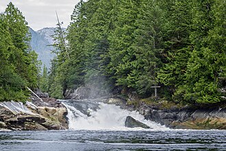 Verney Falls at the head of Lowe Inlet | |
 Interactive map of Lowe Inlet Marine Provincial Park | |
| Location | British Columbia, Canada |
| Nearest city | Prince Rupert, BC |
| Coordinates | 53°33′23″N 129°35′15″W / 53.5564°N 129.5875°W / 53.5564; -129.5875 |
| Area | 765 hectares (1,890 acres) |
| Established | 14 June 1994 |
| Governing body | BC Parks |
| Website | Official website |
Lowe Inlet Marine Provincial Park is a provincial park in British Columbia, Canada located on the Inside Passage of the North Coast, 118 km south of Prince Rupert and 75 km north of Butedale.2 Established on 14 June 1994, the park now contains approximately 765 hectares (1,890 acres) (555 hectares (1,370 acres) of upland and 210 hectares (520 acres) of foreshore).3
Images
-
 Lowe Inlet
References
References
- "Lowe Inlet Marine Park". Protected Planet. Retrieved 2020-09-15.
- "Lowe Inlet Marine Provincial Park". BC Parks. Retrieved 3 August 2014.
- "Lowe Inlet Marine Park". BC Geographical Names. Government of British Columbia – B.C. Geographical Names Office (BCGNO).