Leutenberg | |
|---|---|
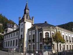 Town hall | |
 Coat of arms | |
Location of Leutenberg
within Saalfeld-Rudolstadt district | |
 Location of Leutenberg | |
Leutenberg Leutenberg | |
| Coordinates: 50°33′N 11°27′E / 50.550°N 11.450°E / 50.550; 11.450 | |
| Country | Germany |
| State | Thuringia |
| District | Saalfeld-Rudolstadt |
| Subdivisions | 12 |
| Government | |
| • Mayor (2021–27) | Robert Geheeb1 |
| Area | |
• Total | 57.52 km2 (22.21 sq mi) |
| Elevation | 300 m (980 ft) |
| Population (2024-12-31)2 | |
• Total | 1,919 |
| • Density | 33.36/km2 (86.41/sq mi) |
| Time zone | UTC+01:00 (CET) |
| • Summer (DST) | UTC+02:00 (CEST) |
| Postal codes | 07338 |
| Dialling codes | 036734 |
| Vehicle registration | SLF |
| Website | www.leutenberg.de |

Leutenberg (German pronunciation: [ˈlɔʏtn̩bɛʁk] ⓘ) is a town in the district of Saalfeld-Rudolstadt, in Thuringia, Germany. It is situated in the Thuringian Forest, 18 km (11 mi) southeast of Saalfeld.
History
Within the German Empire (1871–1918), Leutenberg was part of the Principality of Schwarzburg-Rudolstadt.
References
References
- Gewählte Bürgermeister - aktuelle Landesübersicht, Freistaat Thüringen, accessed 8 March 2022.
- "Bevölkerung der Gemeinden vom Thüringer Landesamt für Statistik" (in German). Thüringer Landesamt für Statistik.