Lapai | |
|---|---|
LGA and town | |
 Interactive map of Lapai | |
Lapai Location in Nigeria | |
| Coordinates: 8°49′N 6°41′E / 8.817°N 6.683°E / 8.817; 6.683 | |
| Country | |
| State | Niger State |
| Government | |
| • Local Government Chairman and the Head of the Local Government Council | Mohammed Musa Kirikpo |
| • Hon. | Umaru Bago Tafida |
| Area | |
• Total | 3,051 km2 (1,178 sq mi) |
| Population (2006 census) | |
• Total | 110,127 |
| • Density | 36.10/km2 (93.49/sq mi) |
| Time zone | UTC+1 (WAT) |
| 3-digit postal code prefix | 911 |
| ISO 3166 code | NG.NI.LP |
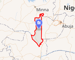
Lapai is a Local Government Area in Niger State, Nigeria, adjoining the Federal Capital Territory. Its headquarters are in the town of Lapai on the A124 highway in the west of the area at 9°03′00″N 6°34′00″E / 9.05000°N 6.56667°E / 9.05000; 6.56667.
It has an area of 3,051 km2 and a population of 110,127 at the 2006 census. The area is roughly coterminous with the Lapai Emirate.
The postal code of the area is 911.1 Lapai is traditionally inhabited by the Muslim Nupe People.
Climatic Condition
Throughout the year, the area's temperature varies, ranging from 62 °F to 94 °F, with sporadic excursions below 56 °F or above 101 °F.23
References
References
- "Post Offices- with map of LGA". NIPOST. Archived from the original on 26 November 2012. Retrieved 20 October 2009.
- "Lapai Climate, Weather By Month, Average Temperature (Nigeria) - Weather Spark". weatherspark.com. Retrieved 10 September 2023.
- "Lapai, Niger, NG Climate Zone, Monthly Averages, Historical Weather Data". tcktcktck.org. Retrieved 10 September 2023.