Labuhanbatu Regency
Kabupaten Labuhanbatu | |
|---|---|
| Other transcription(s) | |
| • Jawi | لابوهن باتو |
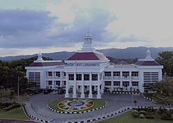 Regent office of Labuhanbatu in Rantauprapat | |
 Coat of arms | |
| Motto(s): Ika Bina En Pabolo (It's Built It's Repaired) | |
 | |
| Coordinates: 2°16′00″N 100°06′00″E / 2.2667°N 100.1000°E / 2.2667; 100.1000 | |
| Country | Indonesia |
| Province | North Sumatra |
| Regency seat | Rantau Prapat |
| Government | |
| • Regent | Maya Hasmita |
| • Vice Regent | Jamri |
| • Chairwoman of Council of Representatives | Meika Riyanti Siregar (Golkar) |
| • Vice Chairpeople of Council of Representatives | Abdul Karim Hasibuan (Gerindra), Juraidah Harahap (People's Conscience Party) and M Rasyid Rangkuti (Nasdem) |
| Area | |
• Total | 2,772.57 km2 (1,070.50 sq mi) |
| Population (mid 2025 estimate)1 | |
• Total | 527,043 |
| • Density | 190.092/km2 (492.336/sq mi) |
| Time zone | UTC+7 (WIB) |
| Website | www |
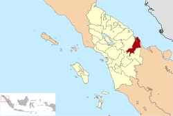
Labuhanbatu Regency (Kabupaten Labuhanbatu, alternatively Kabupaten Labuhan Batu), alternatively written in space as Labuhan Batu Regency, is a regency of North Sumatra Province in Indonesia. Its administrative seat is Rantau Prapat. An original regency (formed on 7 November 1956) of the province, it had an area of 9,703 km2 as of early 2008, prior to the separation out of its southern and its north-western districts respectively to create the new South Labuhanbatu and North Labuhanbatu Regencies on 21 July 2008 (in accordance with Laws Nos. 22 and 23 respectively of that year).
Subsequently, the reduced regency has an area of 2,772.57 km2 and had a census population in 2010 of 415,248,2 which rose to 493,899 at the 2020 Census;3 the official estimate as of mid 2025 was 527,043 (comprising 267,450 males and 259,590 females).1
The Panai Estuary, which consists of the Bilah River and Barumun River, is located in this regency, and it was the seat of the ancient Buddhist trading kingdom of Pannai, ca. 11th to 14th centuries, connected to the Bahal temple in North Padang Lawas Regency.
Administrative districts
Following the separation off of thirteen districts (kecamatan) to form the new South Labuhanbatu and North Labuhanbatu Regencies on 21 July 2008 (in accordance with the enabling Laws enacted on 24 June 2008), the reduced regency is now divided administratively into nine districts, tabulated below with their areas4 and their populations at the 2010 Census2 and the 2020 Census,3 together with the official estimates as of mid 2025.1 The table also includes the locations of the district administrative centres, the number of administrative villages in each district (totaling 75 rural desa and 23 urban kelurahan - the latter chiefly in the town of Rantau Prapat), and its post code.
| Kode Wilayah |
Name of District (kecamatan) |
Area in km2 |
Pop'n Census 2010 |
Pop'n Census 2020 |
Pop'n Estimate mid 2025 |
Admin centre |
No. of villages |
Post code |
|---|---|---|---|---|---|---|---|---|
| 12.0.09 | Bilah Hulu (Upper Bilah) |
385.02 | 56,388 | 64,416 | 67,717 | Aek Nabara | 24 | 21451 |
| 12.10.14 | Pangkatan | 271.13 | 31,738 | 37,766 | 40,290 | Pangkatan | 7 | 21462 |
| 12.10.07 | Bilah Barat (West Bilah) |
291.05 | 33,753 | 39,953 | 42,542 | Janji | 10 | 21411 (a) |
| 12.10.08 | Bilah Hilir (Lower Bilah) |
472.26 | 49,928 | 59,370 | 63,322 | Negeri Lama | 13 (b) | 21471 |
| 12.10.20 | Panai Hulu (Upper Panai) |
225.98 | 33,144 | 38,028 | 40,039 | Tanjung Sarang Elang | 7 | 21470 |
| 12.10.18 | Panai Tengah (c) (Middle Panai) |
584.56 | 33,570 | 41,143 | 44,363 | Labuhan Bilik | 10 (d) | 21472 |
| 12.10.19 | Panai Hilir (e) (Lower Panai) |
391.13 | 35,811 | 42,761 | 45,676 | Sei Berombang | 8 (f) | 21473 |
| 12.10.02 | Rantau Selatan (South Rantau Prapat) |
60.20 | 57,948 | 73,977 | 80,949 | Sioldengan | 9 (g) | 21421 - 21429 |
| 12.10.01 | Rantau Utara (North Rantau Prapat) |
91.24 | 82,830 | 96,485 | 102,145 | Rantau Prapat | 10 (h) | 21411 - 21419 |
| Totals | 2,772.57 | 415,110 | 493,899 | 527,043 | Rantau Prapat | 98 |
Notes: (a) except the desa of Kampung Baru, which has a post code of 21415.
(b) including the two kelurahan of Negeri Lama and Negeri Baru, with 7,113 and 5,108 inhabitants respectively as at mid 2024.5
(c) including the offshore island of Pulau Ongah Labuhan. (d) including the kelurahan of Labuhan Bilik, with 4,110 inhabitants as at mid 2024.6
(e) including the offshore island of Pulau Sikantan. (f) including the kelurahan of Sei Berombang, with 13,590 inhabitants as at mid 2024.7
(g) comprises 9 kelurahan - Bakaran Batu, Danobale, Lobu Sona, Perdamean, Sidorejo, Sigambal, Sioldengan, Ujung Bandar and Ujung Kompas; see Rantau Prapat for details.
(h) comprises 10 kelurahan - Aek Paing, Bina Raga, Cendana, Kartini, Padang Bulan, Padang Matinggi, Pulo Padang, Rantau Prapat, Sirandorung and Siringo-ringo; see Rantau Prapat for details.
References
References
- Badan Pusat Statistik, Jakarta, 27 February 2026, Kabupaten Labuhanbatu Dalam Angka 2026 (Katalog-BPS 1102001.1207)
- Biro Pusat Statistik, Jakarta, 2011.
- Badan Pusat Statistik, Jakarta, 2021.
- Badan Pusat Statistik, Jakarta, 28 February 2025, Kabupaten Labuhanbatu Dalam Angka 2025 (Katalog-BPS 1102001.1207)
- Badan Pusat Statistik, Jakarta, 26 September 2025, Kecamatan Bilah Hilir Dalam Angka 2025 (Katalog-BPS 1102001.1207130)
- Badan Pusat Statistik, Jakarta, 26 September 2025, Kecamatan Panai Tengah Dalam Angka 2025 (Katalog-BPS 1102001.1207150)
- Badan Pusat Statistik, Jakarta, 26 September 2025, Kecamatan Panai Hilir Dalam Angka 2025 (Katalog-BPS 1102001.1207160)