Labelle | |
|---|---|
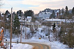 Downtown Labelle | |
 Location within Les Laurentides RCM | |
Labelle Location in central Quebec | |
| Coordinates: 46°17′N 74°44′W / 46.283°N 74.733°W / 46.283; -74.7331 | |
| Country | Canada |
| Province | Quebec |
| Region | Laurentides |
| RCM | Les Laurentides |
| Settled | 1878 |
| Constituted | January 27, 1973 |
| Government | |
| • Mayor | Vicki Emard |
| • Fed. riding | Laurentides—Labelle |
| • Prov. riding | Labelle |
| Area | |
• Total | 215.85 km2 (83.34 sq mi) |
| • Land | 196.69 km2 (75.94 sq mi) |
| Population (2021)3 | |
• Total | 2,765 |
| • Density | 14.1/km2 (37/sq mi) |
| • Change 2016-21 | |
| • Dwellings | 2,017 |
| Time zone | UTC−5 (EST) |
| • Summer (DST) | UTC−4 (EDT) |
| Postal code(s) | |
| Area code | 819 |
| Highways | |
| Website | www |
Labelle (French pronunciation: [labɛl]) is a village and municipality in the Laurentides region of Quebec, Canada, part of the Les Laurentides Regional County Municipality. Its large L-shaped territory surrounds Lake Labelle, and the village is located along the Rouge River and Route 117.
Labelle was named after Curé Antoine Labelle (1833-1891), a Catholic priest who was the pastor of Saint-Jérôme parish from 1868 to 1891. Nicknamed the “King of the North,” he came up with a plan to resettle French Canadians in northwestern Quebec, northern Ontario and Manitoba, in prevent an exodus to the United States. He helped found some 20 parishes and settled close to 5,000 inhabitants in the region.4
History
In the 19th century, the area was known as Chute-aux-Iroquois or Chute-des-Iroquois, referring to a waterfall on the Rouge River that is still known by that name. Around 1878, settlers from Saint-Jérôme, Sainte-Anne-des-Plaines, and Sainte-Scholastique arrived, and the community was known as La Ferme d'en Bas (The Lower Farm). That same year, the La Nativité-de-Marie-de-Labelle Mission was established (becoming a parish in 1901). In 1881, its post office opened under the name Chute-aux-Iroquois, renamed to Labelle in 1894.1
In 1883, the area was originally incorporated as the Township Municipality of Joly.5 On May 28, 1902, the Village Municipality of Labelle was formed when it split off from Joly Township.16
On January 27, 1973, the Township Municipality of Joly and the Village Municipality of Labelle merged to become the Municipality of Labelle.16
Demographics
Historical census populations – Labelle (village 1902–1973, municipality 1973–present) | ||||||||||||||||||||||||||||||||||||||||||||||||||||||||||||||||||||
|
|
| ||||||||||||||||||||||||||||||||||||||||||||||||||||||||||||||||||
| Population counts are not adjusted for boundary changes. Source: Statistics Canada37 | ||||||||||||||||||||||||||||||||||||||||||||||||||||||||||||||||||||
Local government
List of former mayors of Labelle Village:6
- Paul Émile Forget (1902–1903, 1905–1908, 1913–1919, 1921–1925, 1927–1933, 1935–1937, 1939–1945)
- Georges Church (1903–1904)
- J. W. Légaré (1904–1905)
- Joseph Demers (1908–1913)
- James Mc Gibbon (1919–1921)
- John Vallée (1925–1927)
- Ubald Marinier (1933–1934)
- Henri Brassard (1934–1935)
- Côme Bertrand (1937–1939)
- J. Avila Gratton (1945–1946)
- Alfred Bélisle (1946–1949)
- Germain Drouin (1949–1952, 1954–1959)
- Charlemagne Duval (1952–1954)
- Georges Labelle (1959–1963)
- Joseph Delphis Gingras (1963–1966)
- Léonard Vézina (1966–1967)
- Alcide Boivin (1967–1971)
- Robert Labelle (1971–1972)
- Charles Bélisle (1972–1973)
List of former mayors of Labelle Municipality:
- Gilbert Brassard (...–2017)
- Robert Bergeron (2017–2021)
- Vicki Emard (2021–present)
Education
Sainte Agathe Academy (of the Sir Wilfrid Laurier School Board) in Sainte-Agathe-des-Monts serves English-speaking students in this community for both elementary and secondary levels.8
References
References
- "Banque de noms de lieux du Québec: Reference number 32796". toponymie.gouv.qc.ca (in French). Commission de toponymie du Québec.
- "Répertoire des municipalités: Geographic code 78120". www.quebec.ca (in French). Gouvernement du Québec.
- "Profile table, Census Profile, 2021 Census of Population - Labelle, Municipalité (MÉ) [Census subdivision], Quebec". www12.statcan.gc.ca. Government of Canada - Statistics Canada. 9 February 2022.
- Parks Canada Agency, Government of Canada (2022-02-22). "Curé Antoine Labelle — National Historic Person - Curé Antoine Labelle National Historic Person (1833-1891)". parks.canada.ca. Retrieved 2026-02-13.
- "Répertoire des entités géopolitiques: Joly (canton) 1.1.1883 - 27.1.1973". www.mairesduquebec.com. Institut généalogique Drouin. Retrieved 6 May 2026.
- "Répertoire des entités géopolitiques: Labelle (village) 28.5.1902 - 27.1.1973". www.mairesduquebec.com. Institut généalogique Drouin. Retrieved 6 May 2026.
- "1971 Census of Canada - Population Census Subdivisions (Historical)". Catalogue 92-702 Vol I, part 1 (Bulletin 1.1-2). Statistics Canada. July 1973.
- "About Us." Saint Agathe Academy. Retrieved on September 4, 2017. See Elementary zone map Archived 2017-09-04 at the Wayback Machine and Secondary zone map Archived 2017-09-04 at the Wayback Machine - Note that all areas covered in the elementary map are also covered in the secondary one.