Kinbuck Bridge | |
|---|---|
 | |
| Coordinates | 56°13′32″N 3°57′04″W / 56.22560°N 3.95118°W / 56.22560; -3.95118 |
| Carries | B8033 |
| Crosses | Allan Water |
| Characteristics | |
| Material | Stone |
| No. of spans | 2 |
Listed Building – Category B | |
Official name | Kinbuck Bridge Over Allan Water |
| Designated | 4 October 1971 |
| Reference no. | LB3998 |
| Location | |
 Interactive map of Kinbuck Bridge | |
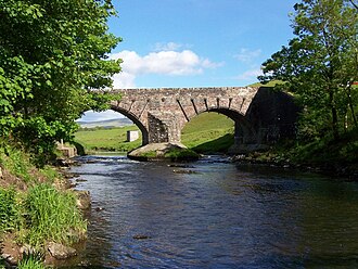
Kinbuck Bridge or Bridge of Kinbuck is a category B listed structure in the hamlet of Kinbuck in Stirling.
History
The present structure is dated 1752.1
In 1715, after resting for the night in Kinbuck, 6,000 Jacobite troops crossed Kinbuck bridge over the River Allan on their way to fight the Hanoverians at the Battle of Sherrifmuir.2
Design
It has two spans, and the central cutwater is protected by a concrete island.1 The weight limit on the bridge is 10 tonnes (9.8 long tons; 11 short tons).3
References
References
- "Kinbuck Bridge". rcahms.gov.uk. Retrieved 12 September 2014.
- Roberts, John Leonard (2002). The Jacobite wars: Scotland and the military campaigns of 1715 and 1745. Edinburgh: Polygon. ISBN 978-1-902930-29-9.
- "Chapter 7: Construction Issues" (PDF). Retrieved 12 September 2014.